to the National Atlas Home page
About | Fact Sheets | Contact Us | Partners | Products | Site Map | FAQ | Help | Follow us on Twitter 
AgricultureBiologyBoundariesClimateEnvironmentGeologyGovernmentHistoryMappingPeopleTransportationWater
to the Interactive Map MakerMap LayersPrintable MapsWall MapsDynamic MapsArticlesMapping Professionals
 

Dynamic Maps

 
  Dynamic Map Icon
Nationalatlas.gov™ contains a remarkable range of products and services to meet the diverse needs of people who are looking for maps and geographic information about America. Dynamic maps are innovative illustrations of geographic phenomena. We combine the science of mapping with today's multimedia to offer maps that are useful, understandable, and that stimulate interactivity.
 
     
  Zebra Mussels
 
Link to Zebra mussels dynamic map. View dynamic Map.

Flash Player required

Directions -
Click the small map to the left to view the Dynamic Map illustrating the spread of the invasive zebra mussel over time. A new window will open containing a brief introduction to the Zebra Mussels Dynamic Map. If you used previous editions of this map, you'll note that its interface has changed. To explore the map, move your cursor over a year near the top of the window or use the VCR controls. VCR controls 

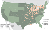
Zebra mussel sighting locations are represented by orange and dark red markers on this map. States where zebra mussels have been found in inland and adjacent waters are identified by a dark olive color. Clicking a year near the top of the window displays a map of zebra mussel sightings in that year. You may also use the VCR controls to start or stop an animation of sightings by year and to move to the first or last map in the animation.

Biology
Map Maker
Invasive Species:  Zebra Mussel Distribution
Map Layer
Articles
Zebra Mussels
 
 
Detailed Information -
For more detailed information about Zebra Mussels go to the Invasive Species - Zebra Mussels article or to a related link below.
Related Links

back to top