Map Layer Info
| Magnetic Field - Secular Variation of the Declination Component for the Epoch 2010.0 |
|
What this map layer shows: The change in magnetic declination in arc-minutes per year. |
|
| Background Information | |
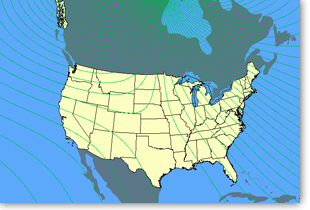 Sample Map
For thousands of years, people have tried to solve the mysteries of the Earth's magnetic field, making the study of geomagnetism one of the oldest of the geophysical sciences. As early as the 1600s, scientists recognized the need for accurate and continuous measurements of the Earth's magnetic field. The first permanent magnetic observatories were established 150 years ago. Today, a global network of more than 200 magnetic observatories, supported by individual national agencies, provides the data that form the foundation for the modern science of geomagnetism. The U.S. Geological Survey (USGS) operates 14 magnetic observatories as part of this global network. As our society becomes progressively dependent upon advanced technological systems, our need for geomagnetic data increases. Information collected on the Earth's magnetic field is used to meet the growing needs of Federal, State, and local governments, industry, academia, and the public. We use geomagnetic data for mineral exploration, military and commercial navigation, and geologic dating. Geomagnetic storms (rapid variations in the magnetic field) pose significant hazards to satellites, electrical power distribution systems, radio communications, and geophysical surveys. The collection of geomagnetic data allows scientists to provide advanced warning of geomagnetic storms. An advanced warning of even a few minutes can save millions of dollars in losses by permitting satellite and power system operators to take mitigating actions. Scientists at the USGS and at other agencies around the world compile data on the magnetic field in five year increments, which is then used to produce a model of the magnetic field called the International Geomagnetic Reference Field (IGRF). Each IGRF model is based on data collected in the recent past, preceding the model's construction, and is intended to represent the field in the near future, following the model's construction. Therefore the model for Epoch 2010.0 is designed to reflect the magnetic field from 2010 to 2015. When referring to a specific model, IGRF is followed by the epoch, as in IGRF 2010. There are five basic elements that describe the direction and intensity of the forces within the magnetic field. Direction is described by declination and inclination; intensity is described by three components: horizontal, vertical, and total field intensity. Five additional elements describe the change over time, or secular variation, of the basic elements. Declination is an important measurement because the magnetic poles of the Earth do not line up precisely with the rotational axis of the Earth. The secular variation of the declination shows how the declination is changing over time. This map layer was produced by the U.S. Geological Survey. The Magnetic Field - Secular Variation of the Declination Component for the Epoch 2010.0 map layer shows the annual change in the declination component as isoporic lines (lines of equal annual change in the declination of the Earth's magnetic field), derived from the International Geomagnetic Reference Field (IGRF) for the epoch 2010.0. Isoporic values are provided in arc-minutes per year. The declination component and the secular variation of the declination component change smoothly over most of the Earth except in a region surrounding each geomagnetic pole. Near the geomagnetic poles, lines of equal declination and the isoporic lines crowd closer and closer together. Also available in the National Atlas are nine additional map layers describing components of the magnetic field. More detailed information on geomagnetism is available from the USGS National Geomagnetism Program and from the National Geophysical Data Center Earth Magnetics page. |
|
| Geology |
| Map Maker Sample |
| Declination Secular Variation |
| Articles |
| Geomagnetism: The Magnetic Field of the Earth |
| Data Download |
| Magnetic Field - Declination Secular Variation |
