to the National Atlas Home page
About | Fact Sheets | Contact Us | Partners | Products | Site Map | FAQ | Help | Follow us on Twitter 
AgricultureBiologyBoundariesClimateEnvironmentGeologyGovernmentHistoryMappingPeopleTransportationWater
to the Interactive Map MakerMap LayersPrintable MapsWall MapsDynamic MapsArticlesMapping Professionals
 

Dynamic Maps

 
  dynamic maps IconNationalatlas.gov™ contains a remarkable range of products and services to meet the diverse needs of people who are looking for maps and geographic information about America. Dynamic maps are innovative illustrations of geographic phenomena. We combine the science of mapping with today's multimedia to offer maps that are useful, understandable, and that stimulate interactivity.  
 

Dynamic Maps

 
down Set of Topographic Maps Illustrating Physiographic Features
down Invasive Species - Zebra Mussel Distribution
down Volcanoes
down Relief and Elevation
 
down Tapestry of Time and Terrain
down Vegetation Growth
down Wildlife Mortality - Avian Cholera
   
   
  Set of Topographic Maps Illustrating Physiographic Features  
  Topographic Maps dynamic map link

Roam your cursor across maps and images to learn about selected features of the American landscape and see how they're represented on topographic maps.

View index map

Geology
Map Maker
Shaded Relief
Map Layer
Wall Map
Physical Features
 
 
back to topup arrow
   
  Invasive Species - Zebra Mussel Distribution - Dynamic Map  
  Invasive Species - Zebra Mussels dynamic map link

This dynamic map shows:

The spread of invasive zebra mussels in the United States between the years 1988 and 2010.

View map and directions

Biology
Map Maker
Invasive Species:  Zebra Mussel Distribution
Map Layer
Articles
Zebra Mussels
 
 
back to topup arrow
   
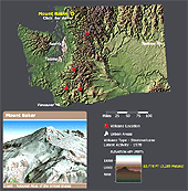
  Volcanoes - Dynamic Map  
  Active Volcanoes dynamic map link

Explore America's potentially active volcanoes with six dynamic maps.

View maps and directions

Geology
Map Maker
Shaded Relief
Volcanoes
Map Layers
Shaded Relief
Volcanoes
Wall Maps
Shaded Relief
Articles
Geologic Hazards
 
 
back to topup arrow
   
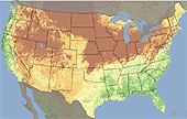
  Shaded Relief- Dynamic Map  
 
Relief and Elevation dynamic map link

This is a map of the conterminous United States that combines a depiction of terrain relief with tinted elevation ranges.

View map and directions

Geology
Map Maker
Shaded Relief
Map Layers
Shaded Relief
Wall Maps
Shaded Relief
 
 
back to topup arrow
   
  Tapestry of Time and Terrain - Dynamic Maps  
 
Tapestry of Time and Terrain dynamic map link

What's been happening in the lower 48 States in the last 2.6 billion years?! Discover this unique combination of geologic and topographic maps and explore American landscapes and the agents that shaped them. 

View maps

Plug-ins required: QuickTime

Geology
Map Maker
Geologic Map
Shaded Relief
Map Layers
Shaded Relief
Generalized Geologic Map
Wall Maps
Shaded Relief
 
 
back to topup arrow
   
  Vegetation Growth in the United States - Dynamic Map  
 
Vegetation Growth dynamic map link

Watch a series of satellite images that illustrate vegetation growth and vigor in Alaska and the lower 48 United States in 2004.

View map and directions

Biology
Wall Maps
Forest Cover Types

Mapping
Articles
What is AVHRR?
 
 
back to topup arrow
   
  Wildlife Mortality - Avian Cholera  
Wildlife Mortality - Avian Cholera dynamic map link

Track known occurrences of avian cholera over the past 50 years using this dynamic map. Interesting articles on wildlife health are only a click away too.

View map and directions

Biology
Map Maker
Wildlife Mortality: Avian Cholera
Map Layer

   
back to topup arrow