

Valley Rainfall
The Tennessee River watershed is one of the rainiest in the United States, with an average of 51 inches of rain a year. The Gulf of Mexico is a major source of moisture. The Tennessee Valley region also is subject to heavy rainfall resulting from dissipating hurricanes moving across the Southeast.
December through early May is the major flood season in the Tennessee Valley. Winter storms provide the most rainfall because they are generally more numerous, last longer and cover larger areas.
In over 100 years of record-keeping, annual rainfall has ranged from 30.65 inches in 2007 to 65 inches in 1973. The greatest extremes occur in the eastern half of the Valley. Average annual precipitation at several places in the mountains of the French Broad, Hiwassee and Little Tennessee River watersheds exceeds 80 inches. In contrast, other locations in the French Broad and Holston River watersheds average less than 40 inches a year.
Average monthly rainfall/runoff comparison
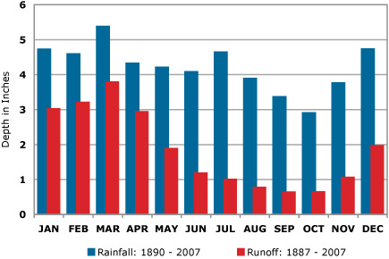
The monthly average rainfall in the Tennessee Valley region ranges from 3.0 to 5.5 inches. March, July and December are typically the wettest months, and September through November are usually the driest. Of course, in any year the wettest and driest months may be different.
The average annual runoff in the region — the amount of water that ends up in the river system after it rains — is about 23 inches, or 44 percent of the average rainfall. The monthly average runoff varies from almost four inches in March to less than one inch in August, September and October.
Generally, runoff is heaviest in winter and early spring when vegetation is dormant and the ground is saturated. As a result, heavy storms moving across the Tennessee Valley region between December and early May become potential causes of major floods.