
Related Resources at the Library
February 2012
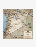
Syria, about the size of North Dakota, encompasses 185,180 sq. km.; it is located in the Middle East along the eastern edge of the Mediterranean Sea, between Lebanon and Turkey. The capital, Damascus, has an approximate population of 1.7 million; it is situated at the Ghouta oasis, fed by the Barada River, and thought to be one of the world's oldest continuously inhabited cities. Other major cities include: Aleppo, Homs, Hama, Idleb, al-Hasakeh, Dayr al-Zur, Latakia, and Dar'a.
The 2010 estimated population was 22.5 million people. The major ethnic groups are: Arabs; Kurds; Armenian, Circassians, and Turkomans. Although Arabic is the official language of Syria, other languages spoken include: Kurdish, Armenian, Aramaic, and Circassian.
Syria was an overwhelmingly agricultural country until the early 1960s, when planned large-scale industrialization began. In the early 1970s, agriculture was still the mainstay of the economy, but industry’s importance increased. Today Syria is a middle-income, developing country with an economy based on agriculture, oil, industry, and tourism.
Syria's climate is mostly desert, with hot, dry, sunny summers (June to August) and mild, rainy winters (December to February); along the coast it experiences cold weather with snow or sleet periodically in Damascus. The terrain is primarily semiarid and desert plateau, a narrow coastal plain, and mountains in the west. The highest point in the country is Mount Hermon at 2,814 meters. The natural hazards facing Syria include: dust and sandstorms and two volcanoes that have not erupted in centuries. Syria's natural resources include: petroleum, phosphates, chrome and manganese ores, asphalt, iron ore, rock salt, marble, gypsum, and hydropower.
U.S. State Department Background Notes; CIA World Factbook; Columbia Gazetteer of the World Online, 01/2012; 02/2012
This map has also been used:
- Syria, July 2011