Home > NCEP Quarterly Newsletter
NCEP Quarterly Newsletter - July 2012
Figure 1. Main entrance to the NOAA Center for Weather and Climate Prediction.
Click image to zoomClick image to zoom
At the end of July, five of NCEP's nine centers (NCO, EMC, HPC, OPC, CPC) and its Office of the Director will begin a phased move into the newly-completed four story, 268,762 sq ft NOAA Center for Climate and Weather Prediction (NCWCP) located in College Park, MD (Figure 1.).
NCEP staff will enjoy a large library, a variety of different sized conference rooms, break rooms on each floor, a fitness center, a deli with an outdoor eating terrace, and a conference center consisting of a 464 seat auditorium and three break-out rooms. The College Park Metro Station is a short ten minute walk away and the near-by University of Maryland offers opportunities for collaboration and synergy.

The new 10,000 sq. ft. data center at the NOAA Center for Climate and Weather Prediction (NCWCP) building in College Park, MD, shown in Figure 2, houses equipment from NOAA's three tenant line offices: NWS's National Centers for Environmental Prediction (NCEP), OAR's Air Resources Laboratory (ARL) and NESDIS' Center for Satellite Applications and Research (STAR) and Environmental Satellite Processing Center (ESPC). Since April, external network connections and the building networking have been completed in the NCWCP and most of the tenant's equipment has been installed in the data center, including core components of NCEP's systems and storage for operational forecasting.

In June, forecasters from NCEP's operational weather desks and NESDIS's SAB desks have run shadow shifts at NCWCP newly built operations desk, shown in Figure 3. Forecasters are comparing products generated at NCWCP with current operational products to confirm that all systems are ready for transition to operations. From now until mid-July, project teams focused on completing the remaining work to be done to prepare the new building for occupancy, which began in late July following the major milestone of the issuance of the Certificate of Occupancy (CO) by Prince George's county to the building's owner and developer.

The phased move will continue throughout the month of August and include dual operations for OPC and HPC beginning in the middle of the month. Move-in will be complete for all groups by the end of September, 2012.

The NCWCP facility is a candidate for silver certification by the U.S. Green Building Council's LEED™ Green Building Rating System, which sets standards for green buildings, verifying that the building is environmentally responsible, profitable, and healthy for occupants. It has environmentally-friendly features such as planted "green roofs", bio-retention areas, efficient use of natural light (Figure 4.) and a storm water cistern to collect water for irrigation.

Figure 1. Main entrance to the NOAA Center for Weather and Climate Prediction.
Figure 2. The data center at NCWCP.
Figure 3. The 4th floor forecast operations area.
Figure 4. Atrium
Figure 4. Atrium

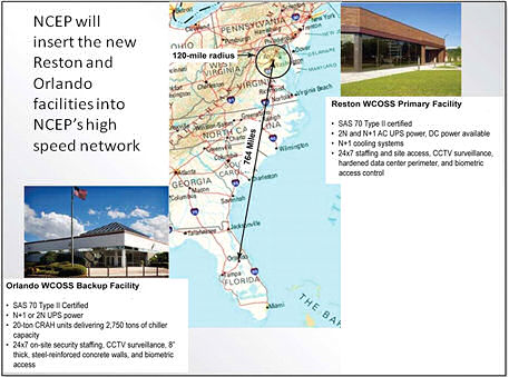
Reston, VA and Orlando, FL are the locations of the primary and backup WCOSS systems beginning Fall, 2013.
Click image to zoomClick image to zoom
The Weather and Climate Operational Supercomputing System (WCOSS) transition project is up and running.
This project will port the software systems/applications from the current Bridge operational supercomputers (Stratus and Cirrus) to two new operational supercomputers located in Reston, VA (primary) and Orlando, FL (backup). Orlando and Reston are 764 miles apart, well beyond the 120 mile distance recommended separation for a primary and backup facility (see Figure1.) At the end of FY13, the primary and backup systems will each be a 208 TeraFLOP system, containing 10,048 cores and 2.59 PetaBytes of useable storage.

The transition team includes development teams across NCEP, NWS and NOAA. These teams are leveraging previous transition work on the NOAA R&D supercomputers (e.g., Zeus and Gaea) to prepare to port and test software systems to the new WCOSS. Currently, the WCOSS project has installed a small early access system with the same architecture as the new WCOSS for early testing and training. A separate test system is in the process of being installed to enable testing of new schedulers, file system and other system capabilities. The first full system will be available to the transition team at the end of August 2012 to start setting up dataflows and the master libraries. By mid September 2012, onboarding of all developers will be in full swing for the transition. The current plan is to be production operational on the new WCOSS by August 2013 but efforts are being made to accelerate this schedule.

Reston, VA and Orlando, FL are the locations of the primary and backup WCOSS systems beginning Fall, 2013.

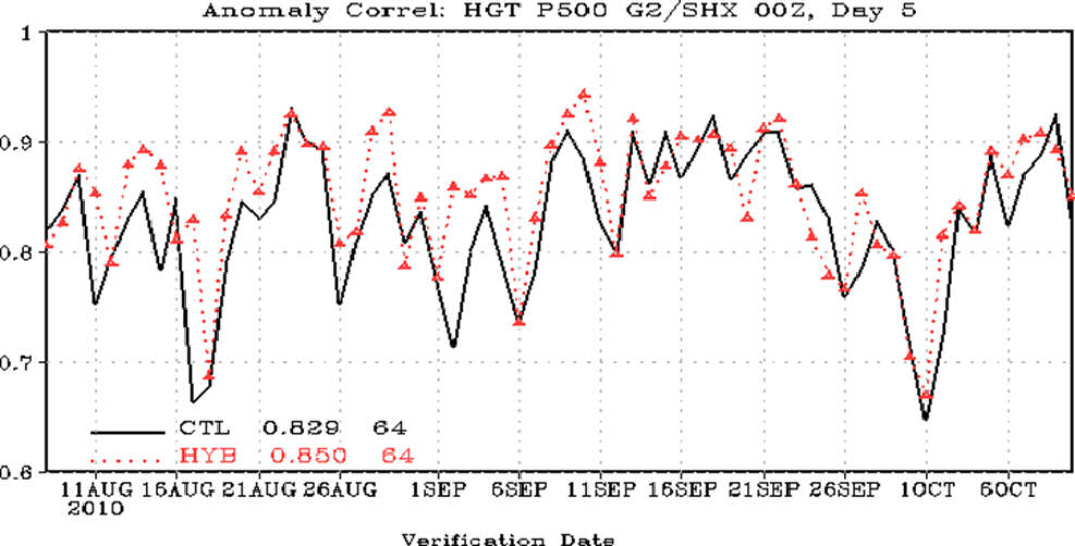
Comparison of 5 day forecast anomaly correlation at 500mb (higher = better) between forecasts from previous analysis system (black) and new hybrid analysis system (red) for period from August - October 2010.
Click image to zoomClick image to zoom
The National Centers for Environmental Prediction - a division of NOAA's National Weather Service - recently upgraded the operational Global Forecast System, which is run four times per day and produces forecasts up to 16 days in advance.
The GFS is the backbone of the National Weather Service's global weather and climate forecasting capability.

On May 22, the upgrade provided a new method for assimilating the billions of pieces of atmospheric data collected daily from Earth observations and satellites. These data are used to describe the current state of the atmosphere, the important first step to running any weather forecast model.

Even with billions of observations, gaps in our depiction of the current atmosphere can lead to forecast errors. The new data assimilation technique uses ensembles, or collections of forecasts, to do a better job than the older system at filling those gaps.

During extensive preoperational testing, the new system produced more accurate forecasts out to 16 days. It also improved hurricane track forecast accuracy, general global weather predictions, and forecasts of stratospheric ozone, which affects the amount of skin-damaging radiation that hits Earth's surface and also affects climate.

"This data assimilation upgrade represents one of the biggest improvements in U.S. weather and climate forecasting in a decade," said Louis Uccellini, Ph.D., director of NCEP. "In the near future, we're going to start noticing more accurate forecasts 16 days in advance. This new ensemble system is a major advancement in numerical weather prediction and will significantly improve our use of atmospheric observations to correct errors in our forecast models."

The new hybrid system is the result of an intensive, three-year collaboration between scientists at NCEP, the NOAA Earth System Research Laboratory (ESRL), NASA and the University of Oklahoma. Further system improvements will be developed over the next few years through continued collaboration between NCEP and ESRL, the University of Maryland and the University of Oklahoma.

Comparison of 5 day forecast anomaly correlation at 500mb (higher = better) between forecasts from previous analysis system (black) and new hybrid analysis system (red) for period from August - October 2010.

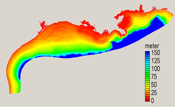
Figure 1. NGOFS Domain - Nowcast and forecast guidance cycles are run 4 times a day (every 6 hours).
Click image to zoomClick image to zoom
On April 3, NOS and NCEP implemented the National Ocean Service's Northern Gulf of Mexico Operational Forecast System (NGOFS)( Figure 1).
NGOFS will provide users with nowcasts (analyses of near present) and forecast guidance of the three-dimensional physical conditions of the northern Gulf of Mexico. The nowcasts will include surface water levels and 3-D water currents, water temperature, and salinity out to 48 hours.
Figure 1. NGOFS Domain - Nowcast and forecast guidance cycles are run 4 times a day (every 6 hours).
On May 1, NCEP implemented the Rapid Refresh model (RAP) V1.0.2 (Figure 2). This hourly model replaces the Rapid Update Cycle model (RUC) in the NCEP Production Model Suite. It will also be used as the first guess for the NCEP Real-Time Mesoscale Analysis (RTMA) for CONUS at both 5-km and 2.5-km resolution. Major enhancements include replacing the RUC 3dvar analysis with the GSI analysis, changing from RUC post-processing to NCEP unified post processing, and increasing the domain from ~55 deg N to a North American domain including all of Alaska, Puerto Rico, and the Caribbean Sea. The Rapid Refresh domain now uses a rotated-latitude-longitude grid, similar to that used for the North American Mesoscale (NAM) model.
Figure 2. Rapid Refresh (or RAP, lower right) performed better than the older RUC model (lower left) in predicting severe weather conditions that occurred in the Midwest on June 21, 2011 (upper right).
On May 15, NCEP implemented the Global Multi-grid Wave Model V3.0.1 (Figure 3). This system runs 4 cycles per day within the NCEP Production Job Suite. This upgrade includes changes in the wave physics which address known biases in the Global Multi-grid Wave Model. The new physics package significantly improves model skill for wave height, especially in regions of strong swells such as the Pacific.
Figure 3. Resolution in minutes of the eight grids making up the Mult-grid Model.
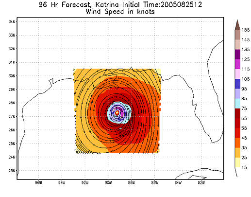
On May 24, NCEP implemented the Hurricane WRF model V6.0.0 (Figure 4). Among many improvements, this upgrade includes a new triple-nesting capability with a new centroid based nest movement algorithm; an inner-most grid at cloud-resolving 3 km horizontal resolution with explicit representation of convective processes; new GFS Shallow Convection; modified SAS deep convection, GFS PBL, redesigned vortex initialization for 3 km resolution and new high-resolution (every 5 sec.) storm tracker output to support National Hurricane Center operations. Test results from these upgrades showed significantly improved track, intensity and structure forecast skills and improved track, intensity and storm radius forecast biases in both Atlantic and Eastern North Pacific basins.
Figure 4. Hurricane WRF output for Hurricane Katrina in 2005.
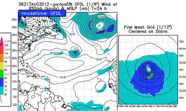
On May 29, an upgrade to the GFDL Hurricane model (Figure 5) was implemented including adjustments to the PBL scheme and Simplified Arakawa-Schubert (SAS) deep convection; GFS Shallow Convection added; surface exchange coefficient (ch, cd) modified; specification of storm size reduced for larger storms. In tests from the 2011 Atlantic hurricane season, these improvements and others resulted in an average reduction of track forecast error of about 12 percent in the 2 to 5 day forecasts. The average reduction in intensity errors averaged nearly 20 percent in the Atlantic basin for the 2011 Atlantic hurricane season, primarily through elimination of the large positive intensity bias.
Figure 5. GFDL Model output for 06Z, August 17, 2012.
Service Center Activities
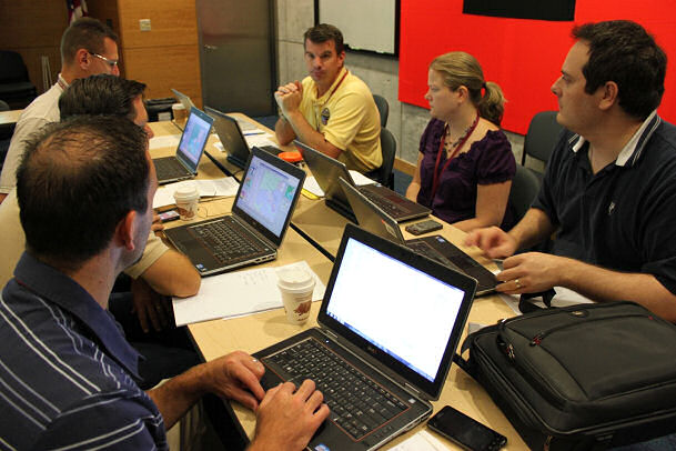
Figure 1. A panoramic view  of the Aviation Weather Testbed (AWT) during the 2012 Summer Exeriment.
Click image to zoomClick image to zoom
The Aviation Weather Center hosted its second Aviation Weather Testbed (AWT) Summer Experiment from June 4-15, 2012.
This year's experiment focused on various high-resolution models, aviation traffic impact decision support services (DSS), derived radar and satellite products, and the generation of a new and experimental Aviation Weather Statement (AWS). Detailed information on the AWT Summer Experiment is available at http://testbed.aviationweather.gov/page/public?name=2012_Summer_Experiment.

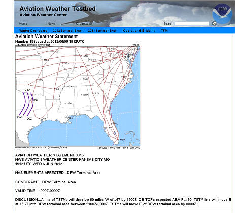
National participants from government, industry, and academia gathered in the AWT to participate in the experiment (Fig. 1). Participants worked in teams at dedicated workstations to evaluate the array of experimental data sets and produce the AWS. There were a total of four experimental desks: two dedicated to traffic flow management (TFM) and DSS, one focused on the evaluation of high-resolution models and ensembles, and one focused exclusively on satellite capabilities and evaluation. The teams at the TFM desks were tasked with producing the AWS (Fig. 2). This event-driven, experimental DSS product is part of the Federal Aviation Administration.s (FAA) Collaborative Decision Making - Weather Evaluation Team's (CDM-WET) Operational Bridging demonstration to support TFM and related DSS. Operational Bridging is a process for event-driven meteorological collaboration between NWS (Central Weather Service Units (CWSU), Aviation Weather Center (AWC), and Weather Forecast Offices (WFO)) and airline industry meteorologists in support of National Air Space (NAS) planning between the FAA and industry. The AWS contains a graphic and text that outlines an area of interest and the potential impact to aircraft operations. Input into the AWS included high-resolution NCEP deterministic models and ensembles, AFWA's 10-member high-resolution ensemble, and observations such as satellite and radar.

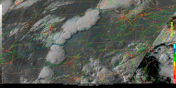
The satellite desk was dedicated to the demonstration and evaluation of a number of future GOES-R products, including model derived synthetic imagery (WRF-ABI), a number of Convective Initiation products, and a Fog/Low Stratus probability. These data were supplied by various research institutes including the Cooperative Institute for Meteorological Satellite Studies (CIMSS), the Cooperative Institute for Research in the Atmosphere (CIRA), NASA's Short-term Prediction Research and Transition Center (SPoRT), and University of Alabama - Huntsville (UAH). The key deliverable from this year's experiment was the AWS, and in that regard, the GOES-R desk was able to assist in its production using the new satellite products, particularly for convective initiation and intensity (Fig. 3). At the same time, those assigned to the desk, particularly AWC forecasters, were able to get a first glance at what GOES-R will have to offer upon its launch and how those tools will be able to provide additional situational awareness for those in aviation operations. For specific examples from the satellite desk, see their blog at http://goesrawt.blogspot.com/.

Similar to the GOES-R satellite desk, the work flow design of the high-resolution model and ensemble desk was constructed to permit a more thorough interrogation and investigation of these data sets. Various visualization tools (within NAWIPS and web-based) were used to interrogate composite solutions from individuals models and ensemble members, such as the Air Force Weather Agency 4-km mesoscale ensemble, the NCEP Storm Scale Ensemble of Opportunity (SSEO), and the High Resolution Rapid Refresh (HRRR). Emphasis was placed on interpreting the envelope of possible TFM impacts by interrogating individual members and the range of possible solutions, and various post-processed ensemble fields describing the likelihood of events (e.g., the probability of convection, lightning, low ceilings and visibility, low level wind shear, icing and turbulence). During the afternoon, the focus shifted to an evaluation of the previous day's model guidance, and included both subjective and objective evaluation methods. More information can be found in their blog at http://awtse.blogspot.com/.

Figure 1. A panoramic view  of the Aviation Weather Testbed (AWT) during the 2012 Summer Exeriment.
Figure 1. A panoramic view of the Aviation Weather Testbed (AWT) during the 2012 Summer Exeriment.
Figure 2. An example of an Aviation Weather Statement (AWS) describing convection approaching DFW on June 6, 2012.
Figure 3. An example of the satellite-derived overshooting tops detection (yellow) and real-time aircraft movement at 0055 UTC June 15, 2012.

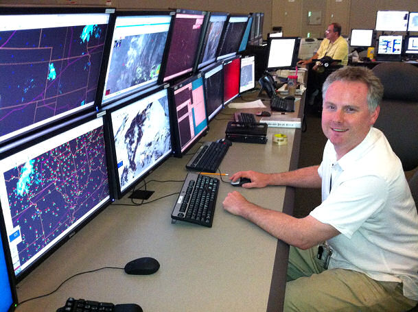
AWC's National Aviation Meteorologist (NAM) Brandon Smith trying out the new NAWIPS, AWIPS II Thin Client, and FAA Traffic Flow Management System installed at the Air Traffic Control System Command Center.
Click image to zoomClick image to zoom
The National Weather Service (NWS) and the Federal Aviation Administration (FAA) have jointly established a weather decision support service at the FAA's Air Traffic Control System Command Center (ATCSCC) in Warrenton, VA.
To meet FAA strategic National Airspace System (NAS) planning and traffic flow management decision support needs, the NWS, through the National Centers for Environmental Prediction's (NCEP) Aviation Weather Center (AWC), will provide National Aviation Meteorologists (NAM). On site NWS NAMs at the ATCSCC will allow traffic management planners direct access to the latest and most complete weather information in the world.

Each year on average, air traffic delays have a greater impact to the U.S. economy than hurricanes do. Most of these delays are related to weather. The NAMs will provide strategic decision support tuned to specific traffic flow management decisions and actions. Traffic and weather specialists working together will improve the Command Center.s ability to take preventive actions and adjust traffic demands accordingly.

The Air Traffic Control System Command Center's (ATCSCC) mission is to balance safety and security with capacity and demand throughout the U.S. National Airspace System. Through collaboration with other system stakeholders and the use of advanced automation tools, ATCSCC personnel plan and regulate the flow of air traffic to minimize delays and congestion while maximizing the overall efficiency of the NAS. The ATCSCC exercises control and oversight of air traffic activity, both civil and military, in domestic and oceanic airspace, with air traffic control field facilities.

The Aviation Weather Center provides aviation warnings and forecasts of hazardous flight conditions at all levels within domestic and international air space. In collaboration with other NWS and industry forecasters, AWC meteorologists deliver consistent, timely and accurate weather information for the world airspace system. To support enhanced planning, the Decision Support Services supplied by the NAMs will integrate all weather forecasts and observation data to identify high impact weather events while also communicating the range of alternative, lower probability solutions. The goal of NAM weather decision support services is to provide detailed weather information focused on the particular traffic flow management scenario each day.

Initially, the joint effort will consists of two meteorologists providing support six days a week. They will have the same operational weather workstations found at the AWC and 122 Weather Forecast Offices across the country. These workstations will put all the weather data available to the NWS at the fingertips of the NAM. By 2014, a contingent of six meteorologists will provide support around the clock, 365 days a year. The NAM will provide weather impacts to the Command Center staff focused to manage the flow of air traffic when weather, equipment, runway closures or other conditions are expected to place stress on the NAS.

AWC's National Aviation Meteorologist (NAM) Brandon Smith trying out the new NAWIPS, AWIPS II Thin Client, and FAA Traffic Flow Management System installed at the Air Traffic Control System Command Center.

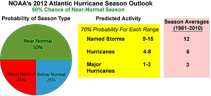
NOAA's 2012 Atlantic hurricane season outlook issued May 24th, 2012. This probabilistic outlook reflects the expected seasonal activity for the entire Atlantic basin, which includes the North Atlantic Ocean, Caribbean Sea, and Gulf of Mexico. The outlook is not a seasonal landfall forecast, and it does not predict levels of activity for any particular region.
Click image to zoomClick image to zoom
The Climate Prediction Center (CPC) issued its 2012 Atlantic hurricane season outlook on May 24th, calling for a 50% chance of a near-normal season.
This outlook is produced in collaboration with hurricane experts from the National Hurricane Center (NHC) and the Hurricane Research Division (HRD). The 2012 Atlantic hurricane season outlook was presented at the NOAA Atlantic Oceanographic and Meteorological Laboratory (AOML) in Miami, FL in a national press conference led by NOAA's Office of Oceanic and Atmospheric Research (OAR) Assistant Administrator Bob Detrick and FEMA Deputy Administrator for Protection and National Preparedness Timothy Manning. The CPC's Dr. Gerry Bell (Lead Seasonal Forecaster) and NHC Director Bill Read were present, addressing scientific questions and doing numerous media interviews. AOML Director Robert Atlas and HRD director Frank Marks were also in attendance.

The 2012 Atlantic hurricane season outlook reflects the possibility of competing climate factors, combined with several circulation and sea surface temperature (SST) features that suggest a less active season compared to many in recent years. Favoring an above-normal season are the ongoing conditions that have been associated with increased Atlantic hurricane activity since 1995, combined with expected near-average SSTs across much of the tropical Atlantic Ocean and Caribbean Sea.

A potential competing climate factor is the possible development of El Niño. If El Niño develops later this summer or early fall, it could make conditions less conducive for hurricane formation and intensification during the peak months (August-October) of the season, thus shifting the activity toward the lower end of the predicted range. NOAA will update its Atlantic Hurricane Season Outlook on August 9, 2012.

The 2011 Atlantic hurricane season featured 19 named storms, 7 hurricanes, and 4 major hurricanes. These totals were generally within the ranges predicted in NOAA's seasonal outlooks issued on May 19 and on August 4.

NOAA's 2012 Atlantic hurricane season outlook issued May 24th, 2012. This probabilistic outlook reflects the expected seasonal activity for the entire Atlantic basin, which includes the North Atlantic Ocean, Caribbean Sea, and Gulf of Mexico. The outlook is not a seasonal landfall forecast, and it does not predict levels of activity for any particular region.

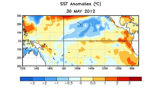
Average sea surface temperature (SST) anomalies (°C) for the week centered on 30 May 2012.  Anomalies are computed with respect to the 1981-2010 base period weekly means.
Click image to zoomClick image to zoom
The Climate Prediction Center issued an El Niño watch with the release of its June ENSO Diagnostics Discussion (EDD) on June 7, 2012.
An El Niño watch is issued when conditions are favorable for the development of El Niño conditions within the next six months. At that time, CPC forecasters assigned a 50% probability that El Niño conditions would develop. Since the 2011-12 La Niña ended in April, sea surface temperatures increased in the eastern half of the tropical Pacific Ocean. At the same time, above-average sub-surface ocean temperatures became established across most of the central and eastern equatorial Pacific. Most of the dynamical models predict El Niño develop during the July - September season, while the majority of the statistical models tend to favor the continuation of ENSO-neutral. If El Niño does develop during the late summer or early fall, it has the potential to suppress tropical storm activity during the peak months (August-October) of the 2012 Atlantic hurricane season.

In addition to potentially impacting the peak of the Atlantic hurricane season, the development of El Niño in the coming months would also have the potential to impact the weather and climate during the winter of 2012-13. The development of El Niño would likely lead to an enhanced probability of above average precipitation across much of the southern part of the nation during the winter of 2012-13, with drier-than-average conditions becoming more likely in the Pacific Northwest and in the Ohio and Tennessee Valleys. El Niño also typically tilts the odds toward a milder-than-average winter across the northern part of the contiguous U.S. and Alaska and colder-than-average temperatures across the Southeast. The EDD is updated on the Thursday following the first Monday of every month and is located here:

http://www.cpc.ncep.noaa.gov/products/analysis_monitoring/enso_advisory/ensodisc.html

Average sea surface temperature (SST) anomalies (°C) for the week centered on 30 May 2012.  Anomalies are computed with respect to the 1981-2010 base period weekly means.
Average sea surface temperature (SST) anomalies (°C) for the week centered on 30 May 2012. Anomalies are computed with respect to the 1981-2010 base period weekly means.

Dr. Zavisa Janjic.
Click image to zoomClick image to zoom
The World Meteorological Organization (WMO) has awarded Dr. Zavisa Janjic, a senior modeler for NWS's National Centers for Environmental Prediction Environmental Modeling Center, its 57th International Meteorological Organization prize.
This award, presented annually for outstanding work in meteorology, is the highest honor bestowed by the WMO. The WMO is a Specialized Agency of the United Nations: the UN's authoritative voice on the state and behavior of the Earth's atmosphere, its interaction with the oceans, the climate it produces, and the resulting distribution of water resources. Dr. Janjic is being honored for his superior work in atmospheric modeling and numerical weather prediction. The citation on the award reads, in part, "In recognition of his outstanding life-long contributions to the advancement of theory and practice of atmospheric modeling and numerical weather prediction, and, in particular, for the development of generations of atmospheric models based on his innovative numerical and parameterization schemes that have been used for research and weather forecasting all over the world inspiring the work of many scientists and producing forecasts reaching millions of users." Dr. Janjic is a valued scientist at NCEP and the entire organization is pleased to see him receive such a distinguished and well-deserved award.
Dr. Zavisa Janjic.
Dr. Zavisa Janjic.

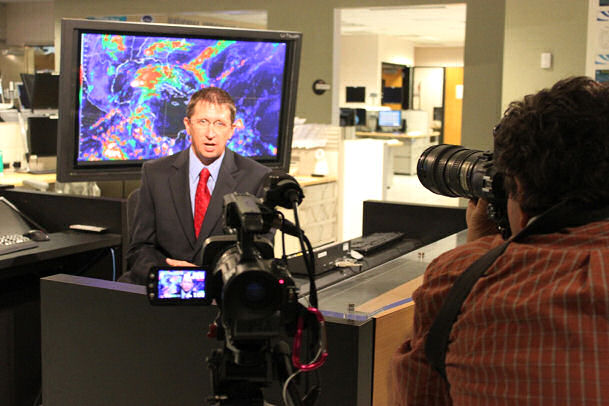
Figure 1. Franco Villela (left), Brazilian student at the HPC International Desks, was interviewed by TV Globo Brazil's Chief Weathercaster Flavia Freira (center), while cameraman Orlando Moreira da Silva (right) recorded the action.
Click image to zoomClick image to zoom
The Hydrometeorological Prediction Center (HPC) International Desks accomplished several milestones this past spring.
In February, the Desks welcomed Dr. Jose Galvez of Peru to the training instructor team. He received his Ph.D. from the University of Oklahoma, where he studied urban meteorology. After an initial familiarization period, Jose joined Mike Davison, HPC International Desks Coordinator, in the daily training activities of the students. In addition to daily training, Jose has started the development of operational techniques to enhance the training and improve forecasts issued by the Desks.

The addition of a second instructor has allowed the Desks to host two intensive training workshops. In April, Mike led a teletraining workshop for the island nations of the Caribbean under the auspices of the Caribbean Institute of Meteorology and Hydrology (CIMH) in Barbados. The well-attended training included presentations on tropical waves, upper troughs and boundary detection. The workshop enhanced CIMH's support to aviation interests and the general public. In June, Mike led a five-day in-residence training workshop in Mexico City. The workshop focused on extratropical and tropical weather phenomena affecting Mexico. Over 26 students completed the 40-hour course.

The Desks' activities have gained particular interest in Brazil. A governmental delegation from the Brazilian National Institute for Space Research visited the Desks in April to learn about the training activities. HPC and the Desks were also recently highlighted by TV Globo Brazil, the most popular Brazilian TV network (Figure 1). The network special report highlighted how important NWS operations are to the welfare of the U.S. and similarly showed the importance of the Brazilian weather services.

The Desks continue to be active. In addition to the daily training and applied research, in August, Mike will participate in a week-long, WMO-sponsored training event in Peru for meteorological instructors, where he will share some of his experiences on distance learning.

Figure 1. Franco Villela (left), Brazilian student at the HPC International Desks, was interviewed by TV Globo Brazil's Chief Weathercaster Flavia Freira (center), while cameraman Orlando Moreira da Silva (right) recorded the action.

FEMA Administrator Craig Fugate prepares for a live television interview from NOAA's National Hurricane Center in Miami regarding the importance of having a hurricane plan.
Click image to zoomClick image to zoom
On the official start of the 2012 Atlantic hurricane season on June 1st, NOAA's National Hurricane Center hosted a media availability to drive home the message of being prepared.
More than three dozen print, radio and television outlets participated in the day-long event.

NHC Director Bill Read, on his last day of federal service, provided interviews along with NHC storm surge team leader Jamie Rhome and NHC senior hurricane specialist Lixion Avila.

Also present was FEMA Administrator Craig Fugate, providing more than a dozen interviews, including NBC's News "Rock Center", who taped a feature story on the Administrator.

FEMA Administrator Craig Fugate prepares for a live television interview from NOAA's National Hurricane Center in Miami regarding the importance of having a hurricane plan.

Dr. Rick Knabb speaks with the media on his second day as the Director of NOAA's National Hurricane Center in Miami.
Click image to zoomClick image to zoom
A childhood dream was realized on June 4, 2012, when Rick Knabb, Ph.D., was sworn in as the new director of NOAA's National Hurricane Center in Miami.
At 43, he is its second youngest director, and comes with a wealth of experience.

Dr. Knabb returns to NHC after having served as its Science and Operations Officer and a senior hurricane specialist in the early to mid-2000s. He spent two years as the Deputy Director of NOAA's Central Pacific Hurricane Center in Hawaii, and another two years at The Weather Channel as its on-air Hurricane Expert and Tropical Science Program Manager.

Dr. Rick Knabb speaks with the media on his second day as the Director of NOAA's National Hurricane Center in Miami.

Participants in the ERMet workshop take part in the hands-on decision-making exercise.
Click image to zoomClick image to zoom
NOAA's National Hurricane Center hosted the first-ever workshop for the new NOAA Emergency Response Meteorologists, or ERMets.
It's a pilot project that's part of a new National Weather Service Weather-Ready Nation concept, designed to provide impact-based decision support and specialized services to key partners.

Facilitators from WFO Miami, Key West, Tampa and Melbourne joined several members of the NHC staff, in providing a week-long short course - "Responding to Tropical Cyclone Emergencies". Topics included the overall hurricane problem, hurricane hazards, and communications and media training. A table-top exercise simulating a hurricane emergency rounded out the workshop.

Participants in the ERMet workshop take part in the hands-on decision-making exercise.

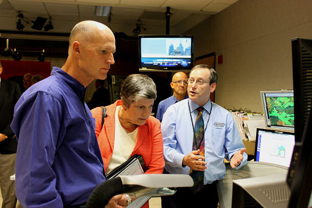
Department of Homeland Security Secretary Janet Napolitano and Florida Governor Rick Scott are briefed about hurricane forecasting by NHC hurricane specialist unit branch chief James Franklin.
Click image to zoomClick image to zoom
Department of Homeland Security Secretary Janet Napolitano and Florida Governor Rick Scott visited NOAA's National Hurricane on the first day of the 2012 Atlantic hurricane season.
Both were provided a tour of the facility by NHC personnel, and joined FEMA Administrator Craig Fugate, outgoing NHC Director Bill Read and incoming NHC Director Dr. Rick Knabb in a closed VTC in the FEMA liaison room, addressing a number of governors of those states in hurricane-prone areas.

A press briefing followed, moderated by NOAA Communications Public Affairs Officer Dennis Feltgen. Brief remarks were provided by Secretary Napolitano, Governor Scott, Administrator Fugate, and Director Read, all with the same theme - be prepared.

Department of Homeland Security Secretary Janet Napolitano and Florida Governor Rick Scott are briefed about hurricane forecasting by NHC hurricane specialist unit branch chief James Franklin.

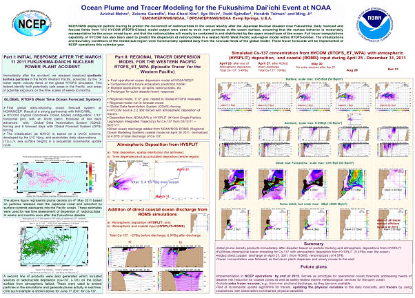
Pilot capability developed by EMC to track oceanic "plumes" using the NCEP operational global ocean forecast model.
Click image to zoomClick image to zoom
The 4th quadrennial intergovernmental session of the Joint World Meteorological Organization-Intergovernmental Oceanographic Commission (WMO-IOC) technical Commission on Oceanography and Marine Meteorology (JCOMM) was held from 23-31 May, 2012 in Yeosu, Republic of Korea.
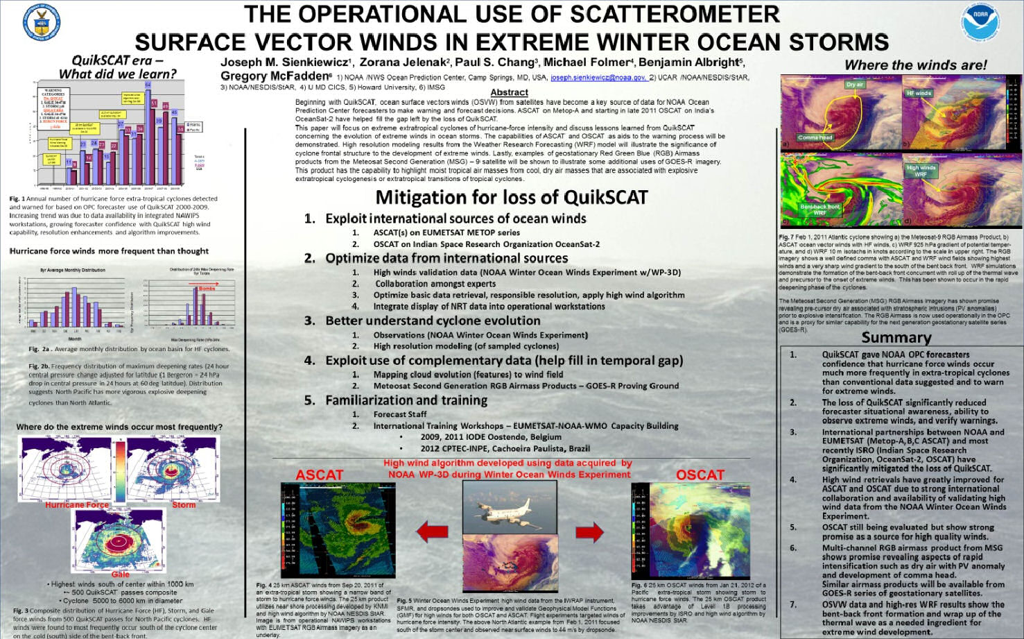
Ocean Prediction Center (OPC) director, Ming Ji, attended the session serving both as a member of the U.S. Delegation, and as the Coordinator for the JCOMM Services and Forecast Systems Program Area (SFSPA). He reported to the Commission SFSPA activities and major achievements during the past inter-sessional period (2009-2012) and the proposed priority work plan for the upcoming inter-sessional period (2012-2017). The session included a two-day Science and Technology Workshop with a theme on "Improving marine and ocean data products for science and society: the role of JCOMM". Ming Ji presented two NCEP posters, the first on a pilot capability developed by EMC to track oceanic "plumes" using the NCEP operational global ocean forecast model (Figure 1), and the second poster on the application of satellite remote sensed ocean surface vector winds for marine warnings and forecasts (Figure 2).

The formal Session approved the JCOMM-4 document that sets the direction and strategies for the Commission, and will guide key Commission activities by various program areas and expert teams for the next inter-sessional period 2012-2117. The U.S. will continue to lead the Services and Forecast Systems Program Area. Ming Ji was re-appointed by the Commission to the post of program area Coordinator. The Commission approved the prioritized work plan for the Service Program Area. These priorities are aligned closely to the U.S. (NWS) marine weather and operational ocean forecasting services priorities, and directly support WMO and IOC programmatic priorities (e.g., the Global Framework for Climate Services an Disaster Risk Reduction)

Among top SFSPA priorities is to enhance the Marine Pollution Emergency Response Support System (MPERSS) capability with a particular focus on supporting the response to events like maritime radioactive hazard discharge (e.g., Fukushima). The main objective is to establish an internationally coordinated support framework for oceanic discharge of radioactive hazards. The framework would mimic the response system for atmospheric dispersion situations, which was established following the Chernobyl accident. NOAA (NCEP) is using the prototype capability to monitor the long term effect of the radioactive discharge from the Fukushima accident.

Another SFSPA priority objective is to collaborate with the International Maritime Organization (IMO) and the International Hydrographic Organization (IHO) to support their e-Navigation initiative by developing graphic met-ocean service products that are compatible to the ship-board Electronic Chart Display Information System (ECDIS) such as sea state analysis and forecasts. OPC and the National Ocean Service Office of Coast Survey (OCS)have initiated a collaborative effort toward such development.

JCOMM leads the implementation of the WMO strategic priority in implementing a Quality Management Framework for maritime safety services. The U.S. (NWS) supports the overall objective of Quality Management approach. In the past year, both OPC and the National Hurricane Center's Tropical Analysis & Forecast Branch drafted a Quality Manual which is the corner stone for a Quality Management system. The U.S. objective is to assure that the international mandate for implementing the Quality Management Framework will not lead to mandates for obtaining ISO certification by national services, but will lead to overall efforts for improved service quality.

Pilot capability developed by EMC to track oceanic "plumes" using the NCEP operational global ocean forecast model.
The application of satellite remote sensed ocean surface vector winds for marine warnings and forecasts.

Joe Sienkiewicz of the OPC instructing students from Ecuador and Brazil on ASCAT capabilities.
Click image to zoomClick image to zoom
The Ocean Prediction Center (OPC) has well over a decade of experience utilizing satellite based ocean wind and wave estimates in support of High Seas and Offshore marine warning and forecast operations.
Beginning in 2009, OPC has been requested to take part in capacity building efforts internationally to instruct marine forecasters in the operational application of satellite based ocean winds from scatterometers and wave heights from satellite altimetry. The first two courses, in December 2009 and 2011, were hosted by the United Nations Educational, Scientific and Cultural Organization (UNESCO) International Oceanographic Data Exchange (IODE) facility in Oostende, Belgium and focused on training students from the Southern Hemisphere maritime nations and Europe, respectively. The most recent course, May 14-19, was hosted by Brazil's Instituto Nacional de Pesquisas Espacials (INPE)/ Centro de Previsao de Tempo Estudos Climaticos (CPTEC) in Cachoeira Paulista, Brazil. 34 marine forecasters and research meteorologists from seven South American nations participated in the week long training course. Instructors were from Europe, Brazil, and the United States.

The course consisted of the theory, capabilities, and limitations of satellite sources of ocean surface winds and waves from scatterometers and altimeters. Case studies for the waters surrounding South America were presented at various times during the week by Joe Sienkiewicz of the Ocean Prediction Center and Stephane Lirola of Meteo France to reinforce points made in the lectures and to give students the opportunity to work with the various data sets from the ASCAT and OSCAT scatterometers and Jason-1 and Jason-2 altimeters. The GEMPAK display and product generation system distributed by UCAR/Unidata was used to give forecasters the opportunity to use integrated display capabilities and to view complementary data sets with the satellite winds and waves. The course was very successful at introducing forecasters to the capabilities of satellite derived winds and waves and the power of integrated display and product generation systems in the forecast process. To help facilitate the use of satellite winds and waves in South America, Brazil's CPTEC has offered to be the data distribution point and local experts in the GEMPAK display system. Students were given DVDs with GEMPAK software and case study data to be used locally.

Joe Sienkiewicz of the OPC instructing students from Ecuador and Brazil on ASCAT capabilities.
International Ocean Vector Winds Science Team (IOVWST) - Utrecht, Netherlands June 12-14
Research and operational meteorologists and oceanographers from around the globe met in Utrecht, the Netherlands for the annual IOVWST to share information concerning satellite derived ocean surface winds. Utrecht is the birthplace of meteorology in the Netherlands with the Royal Dutch Meteorological Institute (KNMI) having been established there in 1854. The first Executive Director was Buys Ballot, a Dutch meteorologist, known for the Buys Ballot law, which describes the relationship of the horizontal wind direction in the atmosphere to the pressure distribution. The three day meeting was held at the Centraal Museum. Since the loss of the NASA QuikSCAT scatterometer, non-US sources of satellite derived ocean winds have been relied upon to fill the gap. Satellite ocean winds are used by forecasters to determine areas of hazardous winds and as the basis for marine wind warnings. Since 2006, the European ASCAT instrument on the METOP-A satellite has been providing partial coverage of ocean winds. METOP-B will be launched this fall with an ASCAT scatterometer. The Indian Space Research Organization (ISRO) built and launched a scatterometer on the OceanSat-2 satellite (OSCAT) in 2009. During the meeting there were many talks discussing the progress and improvements made in the OSCAT data. An international team of wind experts from ISRO, KNMI, NASA Jet Propulsion Laboratory, and NOAA NESDIS Center for Satellite Applications and Research (STAR) have worked very hard together to evaluate the capabilities, validate the quality of the basic measurements, optimize the wind retrievals, and to share in near real time the data. NESDIS STAR OSCAT winds can be found at: http://manati.star.nesdis.noaa.gov/datasets/OSCATData.php/ Several talks at the meeting described the OSCAT winds as being "near QuikSCAT quality". QuikSCAT is considered the gold standard of scatterometer winds.

NOAA NESDIS processed winds from the ISRO OSCAT scatterometer showing the evening passes over the North Atlantic from 0053 - 0420 UTC 29 June 2012.  Colors delineate wind speed in knots according to the color bar in the upper right.
NOAA NESDIS processed winds from the ISRO OSCAT scatterometer showing the evening passes over the North Atlantic from 0053 - 0420 UTC 29 June 2012. Colors delineate wind speed in knots according to the color bar in the upper right.
The Chinese State Oceanographic Administration launched a scatterometer in August 2011 on the HY-2A satellite. Dr. Xialong Dong of Chinese Academy of Sciences presented results on the progress made processing and validating winds from HY-2A. Below is an image of winds from HY-2A from 5 June 2012. At this point it is unclear as to whether near real time data from HY-2A will be made available. The validation talk can be found at: Validation of HY-2A Scatterometer
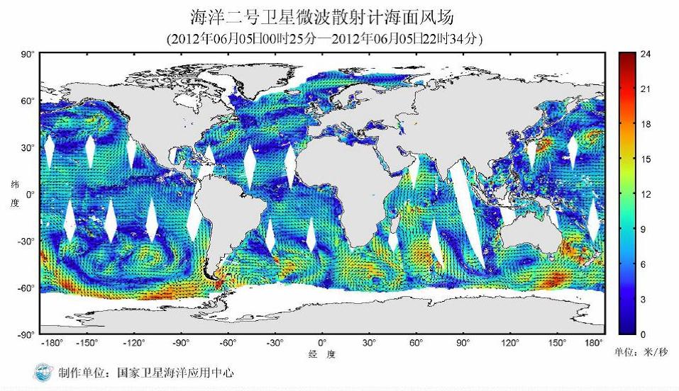
24 hour coverage of winds from Chinese HY-2A scatterometer from 5 Jun 2012.
Joe Sienkiewicz of the OPC gave an update as to the status of ASCAT and OSCAT usage in NWS operations at the OPC and National Hurricane Center (NHC) (Sienkiewicz et al., IOVWST). Presently, OPC and NHC are using the 25 km winds from ASCAT that incorporates the NESDIS STAR high wind capability and KNMI coastal winds. 25 km OSCAT winds are under evaluation by OPC and NHC forecasters. The data is still considered experimental and will likely transition to pre-operational later this year. To benefit all NWS offices with marine responsibility, NCEP Central Operations Systems Integration Branch and NASA SpORT (Short-term Prediction Research and Transition Center) are building the display capability for OSCAT for the AWIPS II workstations.

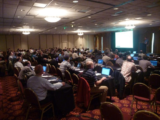
Annual Space Weather Workshop held in Boulder, Colorado.
Click image to zoomClick image to zoom
From April 24-27, NOAA's Space Weather Prediction Center (SWPC), partnering with NASA and the National Science Foundation (NSF), hosted the 13th annual Space Weather Workshop (SWW) in Boulder, Colorado.
The 2012 workshop brought together over 350 researchers, scientists, forecasters and end users from around the world to discuss international coordination of space weather activities, advances in space weather modeling and forecasting, the economic effects of space weather and impacts and the needs of end users.

A few highlights from the week included:

  • Key representatives from most every major US airline attended a special session to explain their concerns, vulnerabilities, and needs from the space weather community with respect to aviation. This important customer-operator-researcher interaction produced critical insight into the concerns of the aviation community and identified a critical need for a solar radiation storm product.
  • Many major satellite groups, both government and private sector, attended. They were keen to learn about a new NOAA effort to assist with space weather anomalies on satellites.
  • On the "new frontier" front, SWPC learned of Virgin Galactic's near-term plans to begin space flight "tourism", and discussed needs for space weather support.
    Annual Space Weather Workshop held in Boulder, Colorado.
    Annual Space Weather Workshop held in Boulder, Colorado.
  • Several representatives from the commercial space weather industry gave presentations during SWW providing an opportunity to demonstrate NOAA's commitment to growing the space weather commercial enterprise and supporting the growing customer base requiring tailored products.
  • A presentation and multiple demonstrations were given of the new space weather capability prototype in AWIPS-2, the next generation processing, display and analysis package currently being developed by the National Weather Service. The key message telegraphed to all researchers in the audience was the capability for them to begin using this system within a year to help increase the rate of Research to Operations (R2O) and Operations to Research (O2R) activities
  • Another special session was held on April 27 where approximately 35 space weather forecasters from around the globe met to discuss improving forecasting through cooperation. Representatives were in attendance from Australia, Canada, China, Ireland, Japan, South Korea, the United Kingdom, and the United States. Techniques for providing the most challenging predictions were discussed. Considerable interest was expressed to enhance the dialog among all forecast offices and to explore mechanisms to utilize complementary skills to accelerate improvement in space weather services.
  • As an extension of the workshop, a weekend session was held with scientists, forecasters, and government agencies to discuss US-UK collaboration on space weather. Near-term and far-term actions were identified for coordinating our effort to advance the data infrastructure and modeling capabilities for space weather services. This workshop, along with an earlier workshop in October, 2011, was facilitated by the UK.s Science and Innovation Network.
  • SWPC were also delighted to host Dr. Tamara Dickinson, Senior Policy Analyst, Office of Science and Technology Policy at the White House. Dr. Dickinson took the opportunity to meet with the many key players in the space weather community, and had a two-hour visit to the SWPC Operations Center to learn about the processes in place to serve the Nation.s space weather needs.
Growing the Space Weather Enterprise Panel Discussion.
Over 350 participants in attendance.

NOAA SWPC Staff join the UK Prime Minister's Chief Science Advisor, Sir John Beddington, and representatives from several UK agencies in a round table to discuss our preparedness for space weather hazards.
Click image to zoomClick image to zoom
Representatives from NOAA's Space Weather Prediction Center participated in the "UK-US Preparedness for Space Weather Hazards", Space Weather Policy Round Table on Tuesday, 26 June 2012, at the International Space Innovation Center in Harwell, Oxford.
This was the third US-UK summit to address opportunities for partnership between our nations in areas of space weather operations, research, modeling, and education. The importance of these workshops was highlighted in the meeting between President Obama and Prime Minister Cameron at the White House in March, 2012. Key among the UK participants was Sir John Beddington, the UK Prime Minister's Chief Science Advisor, who gave the opening keynote address. He was joined by members of the UK Cabinet Office, and representatives from the UK Met Office, Rutherford Appleton Lab (RAL), British Geological Survey, British Antarctic Survey, UK Space Agency, and the Natural Environment Research Council. Dr. Kathy Sullivan, the NOAA Deputy Administrator, provided a key note address by VTC, and provided one of the highlights of the meeting with her announcement that NOAA will provide the Enlil heliospheric model to the UK Met Office. This was certainly recognized by all as an important milestone in our partnering efforts on space weather modeling and prediction, and is an important step in the recent directives from the White House to work with the UK in the development of a real-time UK operational space-weather service.

The core Round Table discussions focused on three areas: 1) Understanding Space Weather Risk; 2) Improving Preparedness: Needs and Opportunities Identified at the UK-US Workshops in May, 2011 and April, 2012; and 3) Communicating Risk and Mitigating Actions - Prior to and During Extreme Events. Both the US and UK representatives discussed their Nation's processes to include space weather in national documents governing risk. Space weather is now included in the UK's National Risk Assessment/Register of Civil Emergencies, and is in the US Strategic National Risk Assessment and National Risk Profile (NRP) documents.

Results from the US-UK workshops (Oct 2011 and Apr 2012) were presented. These workshops created the synergy required to accelerate collaborative research and innovation between our nations. The UK Met Office discussed the importance of UK-US and global information coordination during space weather outbreaks, highlighting lessons learned from volcanic ash and Fukushima. The importance of international exchange and management of data in support of our research and operational efforts was discussed. RAL provided projections and uncertainties on future frequency and strength of extreme events. Participants recognized a strong mutual interest in developing a collaborative and strategic approach joint research and operational activities between the UK and US.

SWPC staff also visited the UK Met Office in Exeter to discuss sharing knowledge, experience, and developing skills in operational space weather forecasting. SWPC is assisting the UK Met Office in developing a space weather analysis and forecast system which will rely on models such as Enlil and physical models of the lower and middle atmosphere and the thermosphere, ionosphere and heliosphere. SWPC will continue to work with the UK Met Office through regular exchange of information about plans and priorities, coordination of research and identification and implementation of collaborative projects.

NOAA SWPC Staff join the UK Prime Minister's Chief Science Advisor, Sir John Beddington, and representatives from several UK agencies in a round table to discuss our preparedness for space weather hazards.

Collaboration is an important activity during the Spring Forecasting Experiment.
Click image to zoomClick image to zoom
The 2012 Hazardous Weather Testbed Spring Forecasting Experiment (SFE) completed its fifth and final week of operations on June 8.
External participants from all CONUS NWS Regions, NCEP's Hydrometeorological Prediction Center, Aviation Weather Center, and Environmental Modeling Center, the Earth System Research Laboratory's Global Systems Division, the Air Force Weather Agency, National Center for Atmospheric Research, NASA-SPoRT (Short-term Prediction Research and Transition Center), Cooperative Institute for Meteorological Satellite Studies - University of Wisconsin, the private sector, academia, and international visitors from Canada, United Kingdom, Switzerland, Spain, and Germany complemented local participants and testbed organizers from the Storm Prediction Center (SPC) and the National Severe Storms Laboratory (NSSL). Overall, nearly 50 forecasters and research scientists participated in the 2012 SFE.

Highlights of the experimental activities included the test and evaluation of a statistical algorithm developed by SPC to provide first guess high temporal resolution probabilistic severe storm guidance for SPC forecasters. This technique utilizes convective scale storm output from the SPC Storm Scale Ensemble of Opportunity, with the guidance spatial probability distribution function constrained by the forecaster-generated full period severe storm outlook. This showed considerable promise for operational forecasting and plans are being developed to test the algorithm within SPC operations. In the convective initiation (CI) component, considerable progress was made in the development of new algorithms to identify the occurrence of CI using observational and model data, and these were applied in forecasting and verification exercises utilizing convection allowing modeling systems including storm scale ensembles. In particular, a new algorithm developed by NSSL demonstrated improved detection capabilities for CI and generalized convective storm coverage.

Collaboration is an important activity during the Spring Forecasting Experiment.
In This Issue...
NCEP Begins Move into NCWCP
NCEP Transition to New Super Computer
GFS Upgrade
Quarterly Implementation Summary
Aviation Weather Testbed Summer Experiments
NWS FAA Decision Support Services
2012 Hurricane Outlook
2012 ENSO Watch
Zavisa Janjic Awarded IMO Prize
HPC International Desks
Hurricane Season Opens at NHC
NHC Welcomes New Director
NHC Trains Emergency Response Mets
Federal and State Leadership Visit NHC
OPC Participates in JCOMM4
OPC Satellite Ocean Wind and Wave Activities
Space Weather Workshop
UK-US Space Weather Activities
2012 Spring Forecasting Experiment
 
Please fill out this comment form and a representative will contact you.

NOTE: Submission of name and/or email address is optional. However, without your complete e-mail address we cannot provide a reply.

Your Full Name:
Your E-mail Address:

Please enter your comments or questions in the space below: