Syndicate content

Blog Category: Storm

NOAA's GOES-15 Weather Satellite Captures Its First Image of Earth

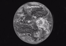
View of Eath taken by GOES-15. Click for larger image.

GOES-15, launched on March 4 from Cape Canaveral, Florida, joins three other NOAA operational GOES spacecraft that help the agency's forecasters track life-threatening weather—from tornadoes, floods and hurricanes—and solar activity that can impact the satellite-based electronics and communications industry. The black and white full-disk image shows North and South America with a storm system visible across the United States, indicated by a drape of clouds from New England westward to the central Plains. Further west is a cold front over the Rocky Mountains. Mostly clear skies are seen over the mid-Atlantic, southeastern U.S., Gulf of Mexico, California and Mexico. (More)

NOAA National Weather Service to Use New Hurricane Wind Scale

Satellite image of Hurricane Ike, 2008. Click for larger image.

NOAA’s National Weather Service will use a new hurricane scale this season called the Saffir-Simpson Hurricane Wind Scale. The scale keeps the same wind speed ranges as the original Saffir-Simpson Scale for each of the five hurricane categories, but no longer ties specific storm surge and flooding effects to each category. Changes were made to the Saffir-Simpson Scale because storm surge values and associated flooding are dependent on a combination of the storm’s intensity, size, motion and barometric pressure, as well as the depth of the near-shore waters and local topographical features. (More)

NOAA Ranks December Snowstorm a Category 3 on Northeast Snowfall Impact Scale

Graphic of snowfall accumulation from Dec. 18-21, 2009 storm. Click for larger image

To the surprise of no one affected by the Dec. 18-20, 2009 system that dumped heavy snow from the mid-Atlantic to southern New England, NOAA has rated the storm a Category 3 or “Major” winter storm on NOAA’s Northeast Snowfall Impact Scale, also known as NESIS. Topping the NESIS scale—and the only storms rated Category 5—are the “Superstorm” on March, 1993 followed by the “Blizzard of ’96” in January, 1996. The scale, developed in 2004, catalogues storms dating back to 1888. (More)

Study: Better Observations, Analyses Detecting Short-Lived Tropical Systems

Satellite image of Tropical Storm Chantal forming south of Halifax, Nova Scotia. Click for larger image.

A NOAA-led team of scientists has found that the apparent increase in the number of tropical storms and hurricanes since the late 19th and early 20th centuries is likely attributable to improvements in observational tools and analysis techniques that better detect short-lived storms. The new study shows that short-lived tropical storms and hurricanes, defined as lasting two days or less, have increased from less than one per year to about five per year from 1878 to 2008. (More)

NOAA Issues Atlantic Hurricane Season Outlook, Encourages Preparedness

Secretary Locke and officials at airport with NOAA plane in background. Click for alrger image

Commerce’s National Oceanic and Atmospheric Administration (NOAA) forecasters say a near-normal Atlantic hurricane season is most likely this year. However, as with any season, the need to prepare for the possibility of a storm striking is essential. “Today, more than 35 million Americans live in regions most threatened by Atlantic hurricanes,” Commerce Secretary Gary Locke said at a Washington, D.C. area airport. “Timely and accurate warnings of severe weather help save lives and property. Public awareness and public preparedness are the best defenses against a hurricane.” (More)