USGS - science for a changing world

North Carolina Water Science Center

Home Information/Data Projects Publications Drought Floods Podcasts About Us Contact
Autumn leaves.

CURRENT CONDITIONS

Current streamflow conditions in North Carolina.

Current streamflow conditions map.
View a detailed map.

DATA CENTER

ABOUT THE NC WATER SCIENCE CENTER

Raleigh Main Office
3916 Sunset Ridge Rd
Raleigh, N.C. 27607
Phone: (919) 571-4000

ABOUT THE USGS

USGS IN YOUR STATE

USGS Water Science Centers are located in each state.

There is a USGS Water Science Center office in each State. Washington Oregon California Idaho Nevada Montana Wyoming Utah Colorado Arizona New Mexico North Dakota South Dakota Nebraska Kansas Oklahoma Texas Minnesota Iowa Missouri Arkansas Louisiana Wisconsin Illinois Mississippi Michigan Indiana Ohio Kentucky Tennessee Alabama Pennsylvania West Virginia Georgia Florida Caribbean Alaska Hawaii New York Vermont New Hampshire Maine Massachusetts South Carolina North Carolina Rhode Island Virginia Connecticut New Jersey Maryland-Delaware-D.C.

Water Resources of North Carolina

Welcome to the USGS North Carolina Water Science Center. These pages are your source for water-resource information collected and interpreted by the U.S. Geological Survey in North Carolina.

Real-time water data for North Carolina

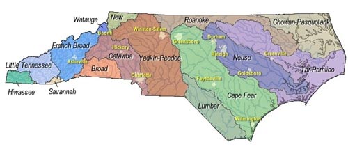
Click on a river basin to obtain real-time data.

Quick Links to Real-Time Data Real-time data typically are recorded at 15-60 minute intervals, stored onsite, and then transmitted to USGS offices every 1 to 4 hours, depending on the data relay technique used. Recording and transmission times may be more frequent during critical events. Data from real-time sites are relayed to USGS offices via satellite, telephone, and/or radio and are available for viewing within minutes of arrival.


View site list: SW | GW | WQ

Of Current Interest

Water in Two Counties to be Sampled and Studied before Possible Shale Gas Exploration

Water from wells in Lee and Chatham counties will be sampled and tested for baseline information because of potential for shale gas exploration in these areas.
NC Shale Gas Baseline Groundwater Sampling Project

The baseline data collected from both private and public water supply wells will be used by state and local agencies to identify background concentrations of major ions, metals, volatile organic compounds, methane gas, and stable isotopes in the aquifer prior to increased shale gas exploration in North Carolina. If shale gas exploration occurs, this data will be used to compare to post-drilling water-quality samples.

Sampling of private wells can be requested from owners at no cost to them, and no well owner names or addresses will be made public. Both Lee and Chatham County Health Departments and supporting partners are providing well records that have been compiled as part of their permitting processes.

Questions regarding this sampling effort and water quality work in Lee and Chatham counties, or an interest in participating in the study, should be directed to Melinda Chapman, USGS, Raleigh, NC, at (919) 571-4047; e-mail mjchap@usgs.gov

Recent Publications
USGS Fact Sheet 2012-3075 Assessment of undiscovered oil and gas resources of the East Coast Mesozoic basins of the Piedmont, Blue Ridge Thrust Belt, Atlantic Coastal Plain, and New England Provinces, 2011

USGS Energy Resources Program

View 'Of Current Interest' Archive

Recent Publications

SIR 2012–5101
Effects of Flood Control and Other Reservoir Operations on the Water Quality of the Lower Roanoke River, North Carolina
By Ana María García
Scientific Investigations Report 2012–5101
SIR 2012-5070
Representation of Regional Urban Development Conditions Using a Watershed-Based Gradient Study Design
By Silvia Terziotti, Gerard McMahon, and Amanda H. Bell
Scientific Investigations Report 2012–5070
OFR 2012-1047
Characterization of Nutrients and Fecal Indicator Bacteria at a Concentrated Swine Feeding Operation in Wake County, North Carolina, 2009–2011
By Stephen L. Harden, Shane W. Rogers, Michael A. Jahne, Carrie E. Shaffer, and Douglas G. Smith
Open-File Report 2012–1047

Search our publications

Podcasts

USGS CoreCast: Groundwater Awareness Week is March 6-12
From large drawdowns in the Great Plains aquifer to arsenic in some wells in New England, this episode of CoreCast highlights six different USGS groundwater studies all across the United States, including Wake County in North Carolina. (7.68 Mb)

Download podcast (right click - save as)
A transcript is available.

North Carolina Podcast Series


The use of firm, trade, and brand names is for identification purposes only and does not constitute endorsement by the U.S. government.

USGS Home Water Climate Change Core Science Ecosystems Energy&Env. Health Hazards

Accessibility FOIA Privacy Policies and Notices

Take Pride in America logo USA.gov logo U.S. Department of the Interior | U.S. Geological Survey
URL: http://nc.water.usgs.gov/index.html
Page Contact Information: North Carolina Web Development Team
Page Last Modified: Monday, 25-Jun-2012 17:21:24 EDT

Lumber Neuse Tar-Pamlico Chowan-Pasquotank Cape Fear Roanoke Yadkin-Peedee New Watauga Catawba Broad French Broad Savannah Savannah Little Tennessee Hiwassee