Nevada Water Science Center
The Nevada Water Science Center (NVWSC) is committed to providing reliable scientific information about Nevada's natural resources to customers, cooperators, and the public. To provide this scientific information, we operate a widespread surface- and groundwater data collection network as well as research a wide range of scientific issues throughout Nevada.
Evapotranspiration
Evapotranspiration (ET) is the process that transfers water from land surface to the atmosphere as evaporation (or sublimation when below freezing) from open water, soil, and plant canopies and as transpiration by plants. ET is measured by scientists for many different reasons. Hydrologists from the Nevada Water Science Center (NVWSC) typically measure ET to help quantify water budgets.
Going Fishing?
USGS operates hundreds of data collection sites in Nevada. These sites provide critical water data to our customers and cooperators for managing Nevada's water resources. But, did you know that our data can also be helpful with planning water activities throughout the state? Fishing and boating enthusiasts use USGS data to determine river and lake conditions so that they can make sure they are prepared for current conditions.
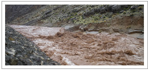
Spring Runoff
During late spring, when the snow in higher elevations begins to melt, rivers and creeks in Nevada begin to have much greater amounts of water in them than they would during summer and winter months. This increase in water in referred to as "spring runoff". Spring runoff varies from year-to-year depending on snow pack depth, air temperature, and precipitation. While spring runoff can be fun to watch, it can also be very dangerous. Streams will be much deeper, colder, and faster moving than other times of the year.
Publications
The NVWSC recently released four new publications. These publications detail studies at the
- Nevada National Security Site
- Diamond Valley flow system
- Spring and Snake Valleys
- Middle Carson River Basin
Additional publications about Nevada are available from the USGS publications Warehouse.
What is this?
Have you ever been near a stream or river and wondered what these buildings are used for?
They aren't outhouses, even though some are shaped just like one. These buildings are actually gage houses and they protect the equipment that we use to measure streams.
Got a Water Question?
We might just have the answer.
We have two main offices in Nevada:
- Carson City Office
- 2730 N. Deer Run Rd.
Carson City, NV 89701 - phone: 775-887-7600
- Henderson Office
- 160 N. Stephanie St.,
Henderson, NV 89074 - phone: 702-564-4600
We also have two smaller field offices:
- Elko Field Office
- phone: 775-778-6616
- Mercury Field Office
- phone: 702-564-4600
Water Data & Information
USGS currently operates hundreds of data collection sites in Nevada for acquiring information on surface water, groundwater, water quality, and precipitation.
- Surface Water
- Stream levels, streamflow (discharge), reservoir and lake levels, water quality, and rainfall.
- Real-time table :: Daily Values :: Peak Flow
- Groundwater
- Site location and description, ground-water levels, and water-quality data for wells and springs.
- Real-time table :: Site Inventory :: Levels
- Water Quality
- Chemical, physical, and biological properties of water and sediment.
- Real-time table :: Samples
NWISweb
USGS water data are stored in the National Water Information System (NWIS). NWIS is a national database and contains data from approximately 1.5 million sites in all 50 states, puerto Rico, the Virgin Islands, Guam, America Somoa, and the Commonwealth of the Northern Mariana Islands. The public can search and download data through NWISWeb. In Nevada, much of the data are available on NWISWeb in near real-time or at periodic intervals. Data also are compiled and published annually in the Nevada water-data report (ADR).
Natural Hazards
Drought: Current and historic information
Floods: Current and historic information
Earthquakes: Real-time information