USGS Water Science Centers are located in each state.
United States Geological Survey (USGS): Water Resources of New York
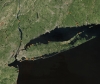
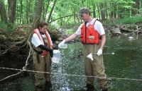
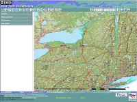
Here you'll find information on New York's rivers, lakes, and estuaries. You'll also find information about groundwater, water quality, and many other topics. The USGS New York Water Science Center operates the most extensive satellite network of stream- and tide-gaging stations in the state, many of which form the backbone of flood-warning systems. The USGS provides current ("real-time") stream stage and surface-water, water-quality, and groundwater levels for over 300 sites in New York.
For emergency situations, please contact Gary Firda, Surface Water Specialist at the USGS New York Water Science Center or call our general number (518) 285-5600 and follow the directions to leave voicemail which will be immediately forwarded to a responsible party and responded to as quickly as possible.
Notice: In anticipation of the arrival of Hurricane Sandy, we will be closely monitoring the situation and any updates will be posted here. Many good references and resources can already be found on our Floodwatch page.
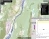
NOTICE (07/12/2012) -- Budget shortfall may result in loss of some critical streamgages. For more information and and the complete list of threatened sites see: real-time water data page or map.
There is no funding, beginning October 1, 2012 (Fiscal year 2013) to support 19 streamgages in the New York portion of the Susquehanna basin Flood Forecast and Warning System and 6 lake and streamgages in the New York portion of the Lake Champlain basin. If no funding is identified, these sites will be shut down on March 1, 2013. These 25 gages are in addition to 6 streamgages slated to be shut down January 1, 2013 and the 8 streamgages that were shut down already because of funding shortfalls.
Although historic data will remain accessible, no new data will be collected unless one or more new funding partners are found. Fact Sheets describe maintenance costs.and USGS streamgage operation ( 1, 2, 3, 4. )
Users who are willing to contribute funding to continue operation of these streamgages should contact Rob Breault or Ward Freeman of the USGS New York Water Science Center at (518-285-5661 or dc_ny@usgs.gov).
NOTICE (05/24/2012) -- Six additional streamgages may be lost on January 01, 2013 due to funding reductions from partner agencies.
Although historic data will remain accessible, no new data will be collected unless one or more new funding partners are found. Fact Sheets describe maintenance costs.and USGS streamgage operation ( 1, 2, 3, 4. )
Users who are willing to contribute funding to continue operation of these streamgages should contact Rob Breault or Ward Freeman of the USGS New York Water Science Center at (518-285-5661 or dc_ny@usgs.gov).
NOTICE (03/01/2012) -- Data collection has been discontinued at two Hudson River estuary monitoring sites (West Point and Piermont Pier) due to funding reductions from partner agencies.
Although historic data will remain accessible, no new data will be collected unless one or more new funding partners are found. For more information and the complete list of threatened sites see:real-time water data page or map. Fact Sheets describe maintenance costs.and USGS streamgage operation ( 1, 2, 3, 4. )
Users who are willing to contribute funding to continue operation of these streamgages should contact Rob Breault or Ward Freeman of the USGS New York Water Science Center at (518-285-5658 or dc_ny@usgs.gov).
NOTICE (03/31/2011) -- 53 groundwater monitoring wells and 6 streamflow stations in Nassau County, NY discontinued.
Data collection at 53 groundwater wells and 6 streams in Nassau County, NY was discontinued on March 15 due to funding reductions from partner agencies. Although historic data will remain accessible, no new data will be collected unless one or more new funding partners are found. For more information, see the threatened groundwater-well and streamflow-station lists at the real-time water data page or the map of sites.
This loss of the majority of the active groundwater- and streamflow-monitoring networks in Nassau County will limit the USGS's ability to seamlessly collect, analyze, and distribute water-table and potentiometric-surface altitudes data across Long Island. Click here for a Fact Sheet describing the maps and data that are collected from this network each year; this loss will leave a large gap in information over Nassau County for current and future years (an interactive map viewer is also available). The loss of these maps and the up-to-date hydrologic data will mean that information is not available for local agencies, water managers, engineers, and the public to evaluate groundwater flooding, contaminant movement, over-pumping, wetlands health, and saltwater intrusion issues across the Region.
Users who are willing to contribute funding to continue operation of these groundwater and streamflow stations in Nassau County should contact Rob Breault or Ward Freeman of the USGS New York Water Science Center at (518-285-5661 or dc_ny@usgs.gov).
 Ask New York USGS