
Water Resources of Pennsylvania
Groundwater flow modeling in the Western Middle Anthracite Coalfield
USGS scientists and cooperating partners estimated water budgets and storage volumes of groundwater in flooded underground coal mines in the Western Middle Anthracite Coalfield. Individual mine collieries were grouped into hydrologic multi-colliery units (MCUs) based on water levels and mine maps. Groundwater flow simulations indicated that additional pumping from the mine pools would be mostly offset by reduced mine discharges. Estimated storage volumes ranged from 60 to 220 billion gallons, depending on assumed mine void ratio.
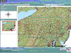 StreamStats for Pennsylvania
StreamStats for Pennsylvania can be used to estimate low-flow, peak-flow, and mean-flow statistics for ungaged and unregulated streams. These streamflow statistics are based on regression equations published in USGS reports. Users should familiarize themselves with the reports before using StreamStats to obtain estimates of streamflow statistics for ungaged sites.
-
StreamStats
Delineate watersheds and estimate streamflow - NWIS Mapper
View the locations of sites with USGS water data - WaterWatch
Compare current streamflow to historical record - WaterQualityWatch
View stream-temperature and water-quality monitoring data - Groundwater Watch
Compare current groundwater levels to historical record - Groundwater Recharge
Compare aquifer recharge for 197 watersheds - WaterAlert
Get condition updates by text message or email
The USGS Pennsylvania Water Science Center is your direct link to all kinds of water-resource information. Data collection and interpretive studies are done in cooperation with various local, State, and Federal agencies.
 Surface Water
Streamflow, lake, reservoir, and precipitation data
 Groundwater
Water levels in wells and other aquifer data
 Water Quality
Chemical and biological quality data for surface water and groundwater
Receive instant updates about water conditions by subscribing to WaterAlert
 Now you can receive instant, customized water condition updates by text message or email by subscribing to WaterAlert, a new service from the U.S. Geological Survey. WaterAlert allows you to receive updates at any of the sites where the USGS collects real-time water information. Daily or hourly updates are sent when current conditions meet or surpass a threshold of concern that you set.
Just What Is a 100-Year Flood Anyway?

Almost everyone has heard the term "100-year flood", but not everyone knows what it really means. A common question is, "we just had a 100-year flood a few years ago, why are we having another one so soon?" The USGS Office of Surface Water has released a poster that explains the concept, probabilistic nature, and inherent uncertainties of a 100-year flood. The poster, entitled "100-Year Flood—It's All About Chance," can be found at http://pubs.usgs.gov/gip/106/.
