to the National Atlas Home page
About | Fact Sheets | Contact Us | Partners | Products | Site Map | FAQ | Help | Follow us on Twitter 
AgricultureBiologyBoundariesClimateEnvironmentGeologyGovernmentHistoryMappingPeopleTransportationWater
to the Interactive Map MakerMap LayersPrintable MapsWall MapsDynamic MapsArticlesMapping Professionals


Map Layer Info


Indian Lands of the United States

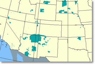
What this map layer shows:

Areas administered by the Bureau of Indian Affairs.

opens the U.S. Geological Survey home page
Background Information
Sample map Sample Map
Indian lands are areas with boundaries established by treaty, statute, and (or) executive or court order, recognized by the Federal Government as territory in which American Indian tribes have primary governmental authority. The Bureau of Indian Affairs is responsible for the administration and management of 55.7 million acres of land held in trust by the United States for American Indians, Indian tribes, and Alaska Natives, and maintains a list of the 562 Federally recognized tribal governments. This map layer was compiled by the National Atlas of the United States®.

The Indian Lands of the United States map layer shows areas of 640 acres or more, administered by the Bureau of Indian Affairs. Included are Federally-administered lands within a reservation which may or may not be considered part of the reservation. There may be private inholdings within the boundaries of the Indian lands in this map layer. Descriptive information includes the area name.


Boundaries
Map Maker Sample
Indian Lands
Printable Maps
Indian Lands
Wall Maps
Federal Lands and Indian Reservations

Data Download
Indian Lands