Map Layer Info
| Satellite View of the United States, with Shaded Relief | |
What this map layer shows: Simulated-natural-color images of the United States, with relief enhanced by shading. |
|
| Background Information | |
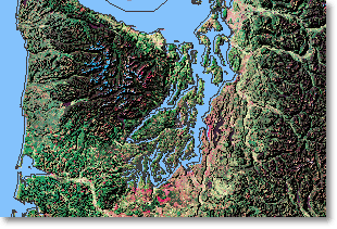 Sample Map
Landsats 5 and 7, the two remaining operational Landsat satellites, fly at an altitude of approximately 438 miles (705 km) and collect data in 7 spectral bands over a 115-mile (185-km) swath. The sensors detect reflected or emitted energy from the Earth in the visible and near-infrared wavelengths. The satellite orbits are Sun-synchronous, which means that the satellites move north to south on the sunlit side of the Earth and cross the equator at the same time each day. Each point on the Earth's land surface is imaged by Landsat once every 16 days. The National Elevation Dataset (NED) is a raster product assembled by the USGS. The NED is designed to provide national elevation data in a seamless form with a consistent datum, elevation unit, and projection. Data corrections are made in the NED assembly process to minimize artifacts, perform edge matching, and fill sliver areas of missing data. The NED has a resolution of one arc-second (approximately 30 meters) for the conterminous United States, Hawaii, Puerto Rico and the island territories and a resolution of two arc-seconds for Alaska. The Satellite View with Shaded Relief map layers were produced by combining Landsat Thematic Mapper (TM) imagery, from bands 2, 4, and 7 of the Landsat 4 (operational from 1982-2001) and Landsat 5 satellites, with NED data. The result is 200-meter-resolution simulated-natural-color images with relief enhanced by shading. Vegetation is generally green, with forests in darker green and grasslands, shrublands, or vegetative tundra in lighter green. Areas of high reflectance, including urban areas, rock, and dry bare soil, are shown in shades of pink. Very bright areas, such as snow and ice, are colored blue. The color of water bodies is influenced by natural and man-made factors such as differences in depth, salinity, pollution, and sediment load, which affect the reflectance of the area. There is one image for the conterminous United States, one for Alaska, and one for Hawaii. The images were developed by the National Atlas of the United States® with data provided by the USGS Center for Earth Resources Observation and Science (EROS). EROS archives, processes, and distributes remotely sensed data, including satellite images and aerial photographs, and works with agencies and organizations around the world to support studies using remotely sensed data. For further information on the source data, see the Landsat fact sheet and the NED fact sheet. Mosaics of TM images, adjusted to correct for positional accuracy and relief displacement, and covering an area of 5 degrees latitude by 6 degrees longitude, are available through the Landsat Orthorectified TM Mosaic page. The National Atlas also includes 200-meter-resolution simulated-natural-color images of the United States which do not include shaded relief. |
|
| Geology |
| Map Maker Sample |
| Satellite View with Shaded Relief |
| Printable Maps |
| Satellite View |
