Blog

Main Content

Lessons from Andrew: CNN’s John Zarrella

Author: 

Editor’s Note: John Zarrella is responsible for CNN's coverage of news in Florida, Central and South America and the Caribbean. Since joining CNN, he has covered every major hurricane to hit Florida and the Gulf Coast.

The views expressed by John Zarrella do not necessarily represent the official views of the United States, the Department of Homeland Security, or the Federal Emergency Management Agency. FEMA does not endorse any non-government organizations, entities, or services.

As we drove south on Florida’s turnpike the damage was getting worse with every mile. At first as I looked to the east and west, it was just trees and power lines down. A bit further road signs and light poles were sprawled across the highway as the first real glimpse of Hurricane Andrew’s destructive force came into view.

By the time we reached Cutler Ridge in South Miami, roofs were gone, facades crumbled, buildings split open. With so much debris now covering the turnpike, we couldn’t go any further.

It was about ten a.m., just five hours after Andrew bulldozed a path of pain and suffering and death across South Florida. The real misery, no homes to come home to, no power, no water, no gasoline, wouldn’t set in for days. When it did, the misery lingered like a fog that wouldn’t lift.

As we walked through what was left of one home, the woman turned to me and said, “Have you ever felt the devil breathing down your neck? We had the devil here last night.” I’ve often wondered during the past twenty years, how she and her family made out. With street signs gone and one demolished neighborhood looking just like the next, we never found her home again.

Much has changed since that August day. The neighborhoods have been rebuilt. Homes are stronger thanks to new building codes that rose up from the rubble Andrew left behind. But when I talk with the experts, there is a real fear that many of us are still not as prepared as we should be despite Andrew and Katrina and Ike and Rita and Wilma and Charlie.

Why? Here’s a case study. I recall quite vividly just twenty-four hours after Wilma, a category three storm, hit Broward County, Florida hard the lines for water and gasoline and propane and groceries sprung up everywhere. People were driving to the west coast of Florida and north to Orlando to find gasoline and generators.

This was the same year as Katrina and Rita. You would have thought for sure people would be ready. They’d have at least three to five days of supplies on hand. On top of that, this was Florida, the best prepared state. And emergency managers say the longer between major storms striking the U.S. the more the hurricane malaise sets in. That’s a false sense of comfort.

Here’s another. I can’t count the times over the years of covering hurricanes for CNN that someone has said to me, they’d been through this hurricane or that one and weren’t evacuating. Problem is they were only in the fringe of the storm.

In the past twenty years since Andrew, technology has vastly improved our ability to communicate warnings before storms hit and to respond more quickly to stricken areas after the storm has passed. The science of forecasting the path of a storm has dramatically improved, reducing the number of people who should evacuate which saves money.

But the ability to forecast rapid changes in intensity either up or down, says Bill Reed the outgoing Director of the National Hurricane Center, isn’t much better now than twenty years ago. Consider this, Andrew was a tropical storm just forty-eight hours before it hit as only the third category five hurricane to ever strike the United States.

With June first upon us, take the time to stock up your hurricane kit. And if you are faced with a decision this year on whether to evacuate, just remember what that woman told me after Andrew. “We had the devil here last night.”

National Dam Safety Awareness Day

Author: 

On May 31, 1889, the South Fork Dam in Johnstown, Pennsylvania failed, killing 2,200 people and leaving thousands homeless. The Johnstown disaster was the worst dam failure before and since 1889 in the United States in terms of lives lost and injuries.

This year, FEMA’s National Dam Safety Program recognized today, May 31, 2012 as National Dam Safety Awareness Day, in commemoration of the devastation of 1889 and as a call to action. FEMA, along with various Federal, State and local stakeholders, attended the event this morning at the Lake Needwood Dam in Rockville, Maryland.

The National Dam Safety Program is a partnership between states, federal agencies, and other stakeholders led by FEMA, to encourage and promote best practices, individual and community responsibility for dam safety and prevention of future catastrophic dam failures.

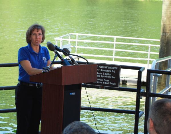
Sandra Knight, Mitigation Deputy Associate Adminsitrator, speaks at the Dam Safety Awarenss Day ceremony at Lake Needwood Dam.Rockville, Md., May 30, 2012 -- Sandra Knight, Mitigation Deputy Associate Adminsitrator, speaks at the Dam Safety Awarenss Day ceremony at Lake Needwood Dam.

The Lake Needwood Dam served as the focal point for Dam Safety Awareness Day because of its urban setting and the successful emergency action planning that took place in response to a severe leakage incident that occurred on July 19, 2006. The planning and response of that incident by state and local officials symbolize exactly what FEMA and its partners strive to achieve through the National Dam Safety Program: a “whole community” approach to emergency management that keeps Americans, their property, and the environment safe from dam failure. National Dam Safety Awareness Day is a day to acknowledge the important work that is being accomplished at all levels of government, and to make a commitment to continue this work to help and create a culture of preparedness and safety in all communities.

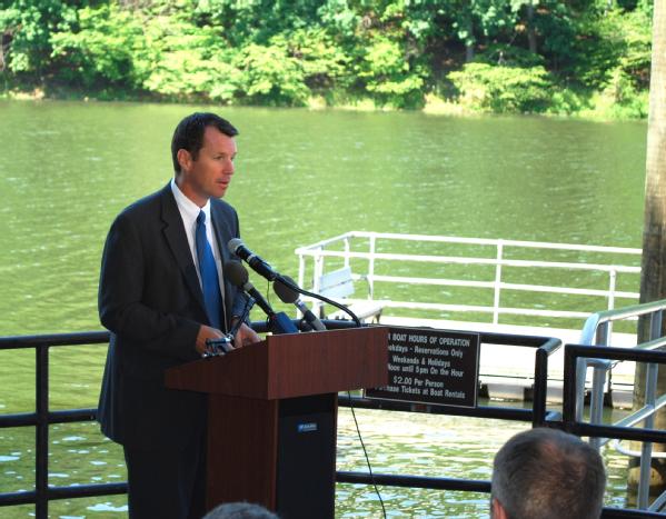
Manning, Deputy Administrator for Protection and National Preparedness, speaks about the National Dam Safety Program.Rockville, Md., May 30, 2012 -- Tim Manning, Deputy Administrator for Protection and National Preparedness, speaks about the National Dam Safety Program.

Fewer storms expected, but it just takes one!

Editor's Note: The views expressed by Phil Klotzbach do not necessarily represent the official views of the United States, the Department of Homeland Security, or the Federal Emergency Management Agency. FEMA does not endorse any non-government organizations, entities, or services.
 
The Tropical Meteorology Project in the Department of Atmospheric Science at Colorado State University along with many other forecasting groups (e.g., NOAA, the UK Met Office, Tropical Storm Risk) are calling for a near-average hurricane season this year. While a somewhat less active hurricane season than the past couple of years is expected, this does not mean that coastal residents should prepare any differently. The recent landfall of Tropical Storm Beryl is a reminder that tropical cyclones can make landfall when a quieter season is predicted, even prior to the official start of the hurricane season.

It only takes one system to make it an active season for you. Devastating tropical cyclones have impacted the United States in very quiet years. For example, in 1992, CSU correctly predicted that only one major hurricane would occur. This major hurricane happened to be Hurricane Andrew, which devastated south Florida. The 1983 Atlantic hurricane season is another good example. That year only had four named tropical cyclones all season, but one of them was Hurricane Alicia which pounded the northern part of Texas. So despite this year’s less active forecast, take time now to get prepared if you live in an area susceptible to the effects of severe tropical weather.

A little history…
CSU has been issuing Atlantic basin seasonal hurricane forecasts annually since 1984. Many individuals have wondered why a university located thousands of miles away from the Atlantic Ocean would issue seasonal hurricane forecasts. Dr. Herbert Riehl, a renowned hurricane researcher from the University of Chicago, came to Colorado to start CSU's Atmospheric Science department in the early 1960s. One of his Ph.D. students at the time was Bill Gray, who came to CSU a couple of years later. Dr. Gray began issuing forecasts when he discovered the relationship between El Niño and Atlantic basin hurricane activity. When El Niño occurs in the tropical Pacific, it increases the frequency during the hurricane season of strong vertical wind shear in the Atlantic, a condition that is detrimental for tropical cyclone formation and strengthening. Since the early 1980s, many other predictors of severe tropical weather have been discovered by CSU and other forecasting groups that impact Atlantic basin hurricane activity. As technology continues to improve, these forecasts will continue to play an important role in educating the public.

The Waffle House Plan - Show Up

Author: 

Editor's Note: The views expressed by Walt Ehmer do not necessarily represent the official views of the United States, the Department of Homeland Security, or the Federal Emergency Management Agency. FEMA does not endorse any non-government organizations, entities, or services.

Preparation is a big part of our job at Waffle House® Restaurants. Since we never close, being prepared for the unexpected is as big a part of our job as is cooking hashbrowns, waffles and eggs. When running a 24/7 restaurant if you don’t plan well, then every day will be an emergency.

This culture of planning for everyday activities is well suited for when an emergency presents itself. Over the last two years, our company has responded to many emergencies - the ice storm in Atlanta, the tornadoes in Missouri, Alabama and north Georgia and Hurricane Irene in the Carolinas. The main part of our plan is what we call “Show Up.” We show up to the area, determine what is needed to get the restaurants open and then do it.

There is logistics planning in staging and getting additional supplies and manpower into an affected area right after a storm, however it’s our show up that sets us apart from other companies. Our planning gets us ready for the storm and so once it has passed our managers can see what’s going on in the area and respond right after an emergency.

We put our leadership on the ground right after the storm to make the decisions needed on where to send the supplies and manpower. Within hours of Hurricane Irene making landfall, our Chairman & CEO, two Executive Vice Presidents, a subsidiary President, our CFO and I were all on site managing the emergency from the front lines.

We had staged some supplies and sent additional manpower into the area. However it was the management on the ground making the decisions about what needed to go where – not someone back in our corporate office in Georgia. This allowed us to quickly respond to the issues at our restaurants.

After each emergency, we look at our planning to decide what worked well and what needs to be tweaked. But the biggest part of our planning is to show up and decide what is needed to keep the restaurants open.

And that’s the big take away for other businesses and individuals. You need to plan ahead and then when the emergency occurs, be ready to be flexible and address the most important issues in front of you. And over time, it simply becomes part of your company’s or home’s culture.

Supporting NATO Activities through Planning and Collaboration

As you may already know, the NATO summit concluded in Chicago, Ill., last Monday, May 22. With the delegations departing to their home countries after two days of important discussion, the interagency support for the summit also comes to a close.

Since learning about the event in November 2011, FEMA through our regional office in Chicago has worked hard with our federal partners to ensure that the state of Illinois and the city of Chicago were well supported before, during and after this high-level event.

FEMA works with the Secret Service, FBI and our other federal partners whenever an event is designated as a National Special Security Event, such as this NATO Summit. FEMA is the lead federal agency for consequence management in the event of a large-scale response to a natural or man-made disaster. This involves coordinating the federal response to and recovery from a major incident.

As co-chair of the Training and Exercise sub-committee, we've helped to facilitate the delivery of specialized training for emergency responders and decision makers and conducted exercises focusing on crisis and consequence management.

In anticipation of any potential federal support, FEMA activated and co-located staff with the Illinois Emergency Management Agency at a Forward Operating Base, in DuPage County, Illinois. FEMA Region V was supported by all Emergency Support Functions, a Defense Coordinating Element, FEMA’s Denver Mobile Emergency Response System, and two Incident Management Assistance Teams.

The College of DuPage, in Chicago’s western suburbs served as an excellent host for our joint operations with the state of Illinois. Their new Homeland Security Education Center, is the regular home to the Suburban Law Enforcement Academy, Criminal Justice and Fire Science/Emergency Medical Services training programs. The facility is complete with an Immersive Training Lab, which provides realistic environmental space for training on many emergency management missions. During the NATO summit, FEMA utilized the space as it was intended – a fully functional Emergency Operations Center.

Here’s a quick video highlighting our unique work at College of DuPage:

A Small Vermont Business Struggles to Make a Comeback and Learns to Prepare for the Future

Author: 

Editor’s Note: Last year, hurricane Irene caused significant flooding in several states along the East Coast well after it made landfall. Since last week was Small Business Administration week and this week is National Hurricane Preparedness Week, we wanted to share this perspective from a small business owner in Vermont. Mr. Crowl experienced first-hand how natural disasters can impact business owners, and has some lessons to share…


The views expressed by Patrick Crowl do not necessarily represent the official views of the United States, the Department of Homeland Security, or the Federal Emergency Management Agency. FEMA does not endorse any non-government organizations, entities, or services.

You can plan for a disaster all you want, but when it hits, you have to put your emotions aside and deal with it like you’re an ER doc. Each decision takes on critical importance.

Few of us in the town of Woodstock would have predicted that Hurricane Irene, which came up the East Coast at the end of last August, would have devastated much of Vermont like it did. But my partners and I, at our popular year round fresh market, the Woodstock Farmers Market, did take some precautions when we knew it was heading our way – we had our employees stay late the night before to move food into freezers and we closed the store down the day the storm was expected.

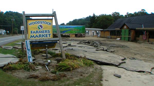
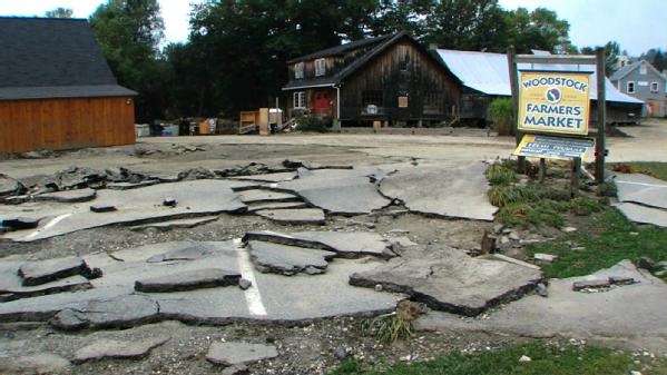
The next day I saw our entire store decimated, covered with mud. I was lucky to have a dedicated staff who did not abandon ship. I had about five staffers who “came to work” and even regular patrons who came by to clean up. People were making lunch, shoveling and mucking. It was surreal and it was very humbling.

Woodstock, Vt., May 23, 2012 -- Damages sustained by Hurricane Irene to Woodstock's Farmers Market.Woodstock, Vt., May 23, 2012 -- Damages sustained by Hurricane Irene to Woodstock's Farmers Market.

We were determined to reopen. We had vendors to pay and a mortgage on the property. The market is the main livelihood for most of the store’s employees. We’re a significant part of the community. We needed to rebuild and get ourselves going again.

But how? I was very familiar with the statistic that only 25 percent of small businesses are able to survive after a disaster. But somehow we managed to reopen in time for Thanksgiving. It wasn’t easy. Over the course of the last year, I have thought about how we did it and have broken down the various stages of business recovery.

Damages sustained to the Woodstock Farmers Market following Hurricane Irene.Woodstock, Vt., May 23, 2012 -- Damages sustained to the Woodstock Farmers Market following Hurricane Irene.

Phase 1 – Days 1 and 2 – Clean-up
Don’t delay what you have to do, take advantage of the momentum of the community right afterwards because things slow down after the adrenaline of the incident wears off, and people have to return to their own lives. If you can, work 12 to 14 hour days. Eight hours won’t cut it. There will be time later to rest. Your reputation is at stake. Your money is at stake.

Set up a command post and gather the right people together. Break down who does what. Don’t be afraid to delegate. Keep lists of who is doing what, and reward community volunteers.

Phase 2 – Days 2 and 3 – Continue the Momentum on the Money Trail
Register with FEMA and the SBA immediately and leave no stone unturned when it comes to other sources of funding. It was a challenge, but I knew I had to stay focused and positive. I would spend full days on the phone navigating the various bureaucracies. We had no manual. We read and reread all the flood insurance literature to make sure we knew the steps to take. We huddled early on with a group of close advisors and came up with a financial game plan.


Phase 3 – Days 3 through 7 – Fine-Tune Your Plan
Take care of your co-workers and staff. Make sure they apply for unemployment and they have access to any needed counseling. Property can be rebuilt, income can be brought back, but foremost make sure people are taken care of. Without them, you won’t be able to come back.

Then do a budget outline of what it will cost to rebuild. Flood expenses can include the cost of the cleanup, construction, new equipment, cost of the insurance adjustor, outstanding payables and any other miscellaneous costs. On the income side, we had to tally our savings, flood insurance proceeds, state economic loan, customer loans and gifts.

My Smartphone was my lifeline. It buzzed and it rang, constantly. Whenever I got an idea, I texted, called or emailed.

We lost all our computer files and many records. Luckily our main computer back up was saved as were many of the computers because before the floodwaters got too high, we carried them to a top floor. But next time, we’re going to make sure we keep a backup data “in the cloud.”

Be prepared to change your game plan. Things are moving a hundred miles an hour and everything changes in a day. We met every day, twice a day for information updates.

We followed the following matrix and updated it every week.

  • Physical plant issues: cleanup; equipment tear out; rebuilding. 
  • Financial issues: insurance, sources of funding 
  • Human Resources: staff communications; unemployment; grief counseling 
  • Marketing/PR: getting the word out; website communication; social media

It was from those meetings that we came up with the idea for our Irene Card program, which was essentially a prepaid shopping card. We offered a discount for cards over $1,000. This idea was a great way to generate money up front. We raised over $375,000 in a matter of weeks.

Phase 4 – After first week – Facing Reality
Your business is gone. Staff is gone. As many people return to their normal lives, you are alone. Keep going. Gather people for weekly meetings and check the matrix.

While we are now open, we still have a gap between what it actually cost to get ourselves back to where we were, versus the cost of the disaster. We were indeed underinsured for our contents, but our building flood insurance was a correct amount. I guess while you can’t plan for a flood, you can be better prepared.

Woodstock Farmers Market reopening following the temporarily closing due to needed renovations caused by Hurricane Irene.Woodstock, Vt., May 24, 2012 -- Woodstock Farmers Market reopening following the temporarily closing due to needed renovations caused by Hurricane Irene.

Knowing what I know now, we have re-examined our flood policy and corrected. A relatively small price to pay for the peace of mind needed when you know Mother Nature could strike at any time.

Beryl Update 2: Follow the Directions of Local Officials As the Storm Comes Ashore

Author: 

As I wrote in yesterday’s blog about monitoring Beryl, FEMA remains in close coordination with our partners at the National Hurricane Center in tracking what is now Tropical Storm Beryl.

On a more personal note, I just happen to be in the Daytona Beach area this weekend visiting family, and I am very appreciative of the information that is coming from state and local officials as it pertains to Beryl’s expected landfall. When it comes to severe weather and the aftermath they leave behind, FEMA always advises individuals to closely monitor the advice of local officials. The latest forecast track for Beryl has prompted tropical storm warnings from the Volusia/Brevard county line in Florida to Edisto Beach, South Carolina.

Staff in our regional office in Atlanta, Ga., and in Washington, D.C., are monitoring Tropical Storm Beryl, and as I noted yesterday, we have deployed a liaison to the National Hurricane Center in Miami, Fla. to share information on current conditions with the regional office and affected states.

The latest from the National Weather Service shows that the storm has maximum sustained winds near 60 miles per hour, with higher gusts. There is little change in strength expected before tropical storm Beryl makes landfall, and tropical storm conditions are expected to reach the coast within the warning area from northeastern Florida to southern South Carolina late this afternoon, and continue throughout tonight.

As can be the case with these systems, dangerous surf conditions, including rip currents, are expected along the coast from northeastern Florida to North Carolina for the remainder of the Memorial Day Weekend. All of us here at FEMA encourage individuals to monitor local radio and television news outlets or listen to NOAA Weather Radio for the latest developments.

On another note, ironically, the hurricane season isn’t supposed to start until June 1, yet we already have our second named storm. As part of leading up to the start of hurricane season FEMA has joined with the National Weather Service to promote hurricane preparedness week – starting today.

On this first day of Hurricane Preparedness Week, FEMA encourages all individuals in hurricane-prone areas to know your risk and make a pledge to prepare at ready.gov/hurricanes. You can complete your emergency preparedness plan, update your emergency kit and Be a Force of Nature and share your preparedness efforts with family and friends.

You can save a life by sharing your readiness tips with others and encouraging them to do the same. Make a YouTube video on how you prepared, share information on Facebook, comment about the importance of preparing on a blog, or post a tweet using #imaforce. And if you’re on other social media sites, post messages there too.

You can also add our preparedness widget on your website to share the information with your website visitors.


We’ll continue to post updates on Beryl as needed, but you should continue to visit hurricanes.gov/ for the latest updates. And this week we’ll have guest bloggers as part of Hurricane Preparedness Week, so stay tuned.

Monitoring Sub-Tropical Storm Beryl

Author: 

Each year the Atlantic tropical season begins on June 1. Generally speaking, any given year during the Memorial Day weekend, employees at FEMA are “thinking” about the upcoming hurricane season…not actually “monitoring” a tropical system. However, this year we haven’t even reached June 1, and we’re already monitoring the second storm of the year. Late yesterday, the tropics developed Sub-Tropical Storm Beryl.

Because of the development of Beryl and the expected track, the National Weather Service has issued tropical storm watches and warning for areas of the southeast. The advisories are for Tropical Storm Warnings for the Volusia/Brevard County line in Florida to Edisto Beach, South Carolina; and Tropical Storm Watches for north of Edisto Beach to South Santee River, South Carolina.

With the impact focused on the southeastern U.S., FEMA, through our regional office in Atlanta, Ga., is closely monitoring Beryl. With tropical storm conditions expected to reach the warned area from northeastern Florida to South Carolina sometime Sunday, we have deployed a liaison to the National Hurricane Center in Miami, Fla., to support our Hurricane Liaison Team.

As tropical waves or tropical storms can bring heavy rains and high winds, we are urging coastal residents to monitor weather conditions by listening to your local radio and television news outlets or by listening to NOAA Weather Radio. You can check your local forecast at weather.gov/ & hurricanes.gov/ and on your phone at mobile.weather.gov & hurricanes.gov/mobile.

It’s vitally important that you take steps to prepare your property and family and you should take steps now to get prepared for potential severe weather. Visit Ready.gov/hurricanes (Listo.gov para español) to learn how to prepare your home and family for a hurricane or tropical storm, including building an emergency supply kit and creating a family emergency plan.

Everyone should also familiarize themselves with the terms that are used to identify a severe weather hazard and discuss with your family what to do if a tropical storm watch or warning is issued in your area. Terms used to describe severe tropical weather include the following:

  • A Tropical storm watch means that tropical storm conditions are possible, in this case within 24 hours.
  • A Tropical storm warning means that tropical storm conditions are expected within 36 hours.
  • A Hurricane watch means that hurricane conditions are possible within 48 hours.
  • A Hurricane warning means that hurricane conditions are expected within 36 hours. 

We’ll continue to monitor the storm and provide updates as it warrants, and if you are in the potential areas, please listen to local officials. We’ll also provide updates on Twitter and Facebook, so you can follow us there too.

Flat Stanley Helps FEMA Prepare for Hurricane Season

Author: 

Back in early April we blogged about a special visitor to FEMA.  At the time, Flat Stanley was making the rounds in Washington, DC and dropped in at FEMA headquarters to spend a little time with me.  Take a look at the latest meeting I had with Flat Stanley and what we have in mind for helping prepare everyone for hurricane season.


FEMA, through our Ready Campaign, is working in collaboration with Flatter World and the Flat Stanley Project to bring awareness to school aged children about the need to be prepared for emergencies and disasters and what they can do to help their families and loved ones to build more resilient households.

Children and their parents will soon be able to build their own FEMA Flat Stanley and share with their friends and classmates the steps they have taken to support preparedness throughout their homes, schools and communities.

Stay tuned for more information as Flat Stanley gets more and more involved.  And in the mean time, kids can find fun preparedness games and activities like word searches, crossword puzzles, comic strips and more at Ready.gov/kids.

Pages

Back to Top