Government on Facebook
is on Facebook.
To connect with Government on Facebook, sign up for Facebook today.
Sign UpLog In
  1. Today is Election Day in the United States and Facebook is committed to encouraging people who use our service to participate in the democratic process. As a result, Facebook is focused on ensuring that those who are eligible to vote know w...
  2. Recent Posts by Others on Government on FacebookSee All
    • Now that the people of America have spoken, we have exercised our rights to choose, it is now time for the rest of the people we have sent to Washington to do their jobs as well. This is not a sandbox game, we are not children. This is not about a persons skin tone or religious beliefs, their orientation, but it is about "We The People". It is not about you ad how you look, but about America and how we fell as a nation about the jobs you are doing. It is time to work together to get back on track. We are not the 1% but we are the 100%, and only as that can we stand together and become a stronger nation. Stop the bickering, remove the special interest from the decision making process and begin deciding for all. The Revolutionary War was fought to get away from the tyranny of stomping the common man into the ground. We fought to get away from that type of rule and refuse to go back. It is time again to follow the wishes of The People, and not follow the wishes of those of the dollar.
      4 hours ago
    • props for Obama. This term Wendy's and Burger King will join Obamacare and give us the choice of fruit instead of french fries. You have saved the world!
      11 hours ago
    •  WILL AMERICA'S REELECT OF PRESIDENT OBAMA AS DESTINY OF AMERICA MAKE AMERICA'S POLICIES ABOVE CLASSIFICATION AND RIGHTS AS AMERICA'S DUTIES AS CHANGE IN IT'S LAWS UNDER SECULAR, EVEN IF, SPIRITUAL MORALITY --AMERICANS' WELL BEING? I RESERVE MY CONGRATULATIONS TO PRESIDENT OBAMA BECAUSE I WOULD LIKE TO SEE HOW FAR AMERICANS' STAND WITH CHANGE AS PROPOSED AND APPROVED BY PEOPLE OF AMERICA AND THEIR REPRESENTATIVES INCLUDING REELECTED PRESIDENT OBAMA. GOD BLESSES AMERICA, AMERICANS AND PRESIDENT OBAMA AND MITT ROMNEY. See, www.holygitaformoraljustice.com; See also, http://www.facebook.com/photo.php?fbid=445208145518990&set=pb.182753868431087.-2207520000.1352119679&type=3&theater; Advocate, Prof., Dr. Brij Mohan Dhir, S.J.D.
      17 hours ago
    • Sherry Suttles Thomas
      I Sherry Suttles Thomas,believe with ALL MY MIGHT AND BEING that EVERYONE drawing ANY KIND of PUBLIC OR GOVERNMENT ASSISTANCE should have to consent to a DRUG TEST!!!! IF YOU,IN ANY WAY SHAPE OR FORM,ARE GETTING STATE OR GOVERNMENT ASSISTANCE, YOU SHOULD TAKE A DRUG TEST.If you are found guilty of drugs,you should be denied from ALL ASSISTANCE UNTIL FOUND CLEAN ONN YOUR DRUG SCREENING!!! I SHERRY THOMAS SOLEMELY SWARE TO FIND JUSTICE FOR THE WORKING MAN.I PLEDGE TO BATTLE EVERYDAY AGAINST L.U.P.U.C. LAZY,USELESS,PATHETIC,UNITED,CITIZENS It only takes 1 LOUD VOICE!!!! AND I GOT IT!!!!
      21 hours ago
    •  In order to maintain bilateral relations in the areas of business cooperation between Indonesia and the United Kingdom, making the British Government and the Queen of England has been blind to the sovereign rights of the people of West Papua in the region, and blind to the crime that has been done by the government under the leadership of President Yudhoyono. http://souisapaul81.blogspot.com.au/2012/11/demi-menjaga-hubungan-bilateral-pada.html By Paul Bastian Souisa
      Yesterday at 4:29pm
  3. It's Election Day in the United States and polls are opening soon. If you don't know where to vote, please check our Polling Place Locator and share it with your Facebook friends.
    The U.S. Politics on Facebook page highlights the use of Facebook by politicians, elected officials, and political campaigns. The Page also shares tips and best practices as well as news from Facebook.
    Page: 246,301 like this
  4. Facebook users in the United States can find their polling place ahead of Election Day tomorrow with our Polling Place Locator developed jointly by Microsoft, Facebook, and the nonpartisan Voting Information Project. Click the link to find out where you should cast your ballot tomorrow:
    The U.S. Politics on Facebook page highlights the use of Facebook by politicians, elected officials, and political campaigns. The Page also shares tips and best practices as well as news from Facebook.
    Page: 246,301 like this
  5. Do you have a Facebook story from Hurricane Sandy? Tell us here: http://www.facebookstories.com/stories/new
  6. The FEMA Federal Emergency Management Agency app is showing lots of open shelters along the East Coast. Download the FEMA app from the Google Play, iTunes, or Blackberry store and pack your phone with safety tips & resources.

    You can also ...
    find open shelters by:

    - Texting "Shelter" and a zip code to 43362 (example: Shelter 01234)...standard rates apply
    - Visiting the American Red Cross shelter map http://www.redcross.org/find-help/shelter
    - Contacting your state or local emergency management office. Here's a map where you can click on your state for info: http://www.ready.gov/today
    See More
    (Oct. 29) The FEMA app is showing lots of open shelters along the East Coast for Hurricane Sandy. Download the FEMA app from the Google Play, iTunes, or Blackberry store and pack your phone with safety tips & resources.

    You can also find o...
    pen shelters by:

    - Texting "Shelter" and a zip code to 43362 (example: Shelter 01234)...standard rates apply
    - Visiting the American Red Cross shelter map http://www.redcross.org/find-help/shelter
    - Contacting your state or local emergency management office. Here's a map where you can click on your state for info: http://www.ready.gov/today
    See More
    Photo: (Oct. 29) The FEMA app is showing lots of open shelters along the East Coast for Hurricane Sandy. Download the FEMA app from the Google Play, iTunes, or Blackberry store and pack your phone with safety tips & resources.

You can also find open shelters by:

- Texting "Shelter" and a zip code to 43362 (example: Shelter 01234)...standard rates apply
- Visiting the American Red Cross shelter map http://www.redcross.org/find-help/shelter 
- Contacting your state or local emergency management office.  Here's a map where you can click on your state for info: http://www.ready.gov/today
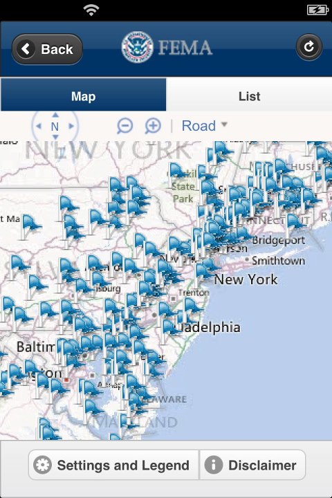
  7. Here's a cool video posted by NOAA Administrator Dr. Jane Lubchenco and an excerpt of her post. You can read the full post at https://www.facebook.com/NOAA.Lubchenco:

    "...If you're in Sandy's path, please stay someplace safe, heed NOAA's a...
    nd your emergency managers' alerts, and check on your family, friends and neighbors. Among the many images of Hurricane Sandy, here's one you'll not see elsewhere because it is still an experimental product currently under development. It's derived from a Super Rapid Scan Operation onboard NOAA’s GOES-14 satellite. By focusing on a specific area, the GOES-14 SRSO captures data every minute and sends that information to forecasters on the ground. Here's a brief video that will give you a glimpse of the capabilities of that new system..."
    See More
  8. Maryland Gov. Martin O'Malley posted a video message about Hurricane Sandy this morning on the Maryland Emergency Management Agency (MEMA) Facebook page. Take a look:
  9. New Jersey Governor Chris Christie live-streamed his latest update on Hurricane Sandy and then posted the video-on-demand on Facebook as well.
  10. New York City Mayor Mike Bloomberg is keeping citizens up to date on Hurricane Sandy news and information by posting updates and photos on Facebook today. Take a look:
    NYC is ready for Sandy. Whenever we’re faced with a tough situation, New Yorkers always pull together.
    Photo: NYC is ready for Sandy. Whenever we’re faced with a tough situation, New Yorkers always pull together.
  11. The National Guard is bracing for Hurricane Sandy by deploying nearly 2,000 citizen-soldiers and airmen along the East Coast:
    This morning, nearly 2,000 National Guard Citizen-Soldiers and Airmen are on duty in Delaware, Massachusetts, Maryland, North Carolina, New Jersey, New York, Pennsylvania and Virginia.
    Photo: This morning, nearly 2,000 National Guard Citizen-Soldiers and Airmen are on duty in Delaware, Massachusetts, Maryland, North Carolina, New Jersey, New York, Pennsylvania and Virginia.
  12. Here's the latest on Hurricane Sandy's path from the NOAA NWS National Hurricane Center:
    Hurricane Sandy is centered tonight about 485 miles south-southeast of New York City, moving toward the northeast. It should turn toward the north and then northwest overnight and early Monday, and will be near the mid-Atlantic coast Monday...
    Night.

    This historic system is forecast to bring life-threatening storm surge flooding to the mid-Atlantic coast, including Long Island Sound and New York Harbor, as well as coastal hurricane-force winds...and even heavy Appalachian snow.

    Maximum sustained winds are 75 mph - a Category One hurricane on the Saffir-Simpson Hurricane Wind Scale. Sandy is expected to transition into a frontal or wintertime low pressure area before landfall, but is not expected to weaken during that transition. In fact, it may strengthen during this process. It will not weaken until after moving inland.

    Hurricane-force winds are expected along the coast from Chincoteague, Virginia, to Chatham, Massachusetts. This includes the tidal Potomac from Cobb Island to Smith Point, the middle and upper Chesapeake Bay, Delaware Bay, the coast of the northern Delmarva Peninsula, New Jersey, the New York City area, Long Island, Connecticut and Rhode Island.

    A significant and dangerous storm surge is expected to occur in the mid-Atlantic states and southern New England. If the peak surge occurs at the time if high tide, the depths above ground level could reach 6 to 11 feet at Long Island Sound and Raritan Bay, and 4 to 8 feet from Ocean City, Md., to the Connecticut/Rhode Island state line, and 3 to 5 feet from there to the south shore of Cape Cod, including Buzzards Bay and Narragansett Bay.

    A Tropical Storm Warning continues along the North Carolina coast from north of Surf City to Duck, including Pamlico and Albemarle Sounds, as well as Bermuda.

    Other coastal and inland watches and warnings are in effect for much of the mid-Atlantic states and New England. See the statements being issued by local National Weather Service offices, www.weather.gov for the details.

    Total rainfall amounts of 3 to 6 inches, with isolated 8 inch amounts, are possible over far eastern North Carolina. Amounts of 4 to 8 inches, with isolated 12 inch amounts, are possible over portions of the mid-Atlantic States, including the Delmarva Peninsula. Amounts of 1 to 3 inches, with isolated 5 inch amounts, are possible across southern New York through New England.

    Snow accumulations of 2 to 3 feet are expected in the mountains of West Virgina, with locally higher amounts, tonight through Tuesday Night. The southwestern Virginia mountains are forecast to see 12 t o18 inches of snow.

    Get the latest on this tropical cyclone, including storm surge information and graphics, on the NOAA NHC website at www.hurricanes.gov
    See More
    Photo: Hurricane Sandy is centered tonight about 485 miles south-southeast of New York City, moving toward the northeast. It should turn toward the north and then northwest overnight and early Monday, and will be near the mid-Atlantic coast Monday Night.

This historic system is forecast to bring life-threatening storm surge flooding to the mid-Atlantic coast, including Long Island Sound and New York Harbor, as well as coastal hurricane-force winds...and even heavy Appalachian snow.

Maximum sustained winds are 75 mph - a Category One hurricane on the Saffir-Simpson Hurricane Wind Scale. Sandy is expected to transition into a frontal or wintertime low pressure area before landfall, but is not expected to weaken during that transition. In fact, it may strengthen during this process. It will not weaken until after moving inland.

Hurricane-force winds are expected along the coast from Chincoteague, Virginia, to Chatham, Massachusetts. This includes the tidal Potomac from Cobb Island to Smith Point, the middle and upper Chesapeake Bay, Delaware Bay, the coast of the northern Delmarva Peninsula, New Jersey, the New York City area, Long Island, Connecticut and Rhode Island.

A significant and dangerous storm surge is expected to occur in the mid-Atlantic states and southern New England. If the peak surge occurs at the time if high tide, the depths above ground level could reach 6 to 11 feet at Long Island Sound and Raritan Bay, and 4 to 8 feet from Ocean City, Md., to the Connecticut/Rhode Island state line, and 3 to 5 feet from there to the south shore of Cape Cod, including Buzzards Bay and Narragansett Bay.

A Tropical Storm Warning continues along the North Carolina coast from north of Surf City to Duck, including Pamlico and Albemarle Sounds, as well as Bermuda.

Other coastal and inland watches and warnings are in effect for much of the mid-Atlantic states and New England. See the statements being issued by local National Weather Service offices, www.weather.gov for the details.

Total rainfall amounts of 3 to 6 inches, with isolated 8 inch amounts, are possible over far eastern North Carolina. Amounts of 4 to 8 inches, with isolated 12 inch amounts, are possible over portions of the mid-Atlantic States, including the Delmarva Peninsula. Amounts of 1 to 3 inches, with isolated 5 inch amounts, are possible across southern New York through New England.

Snow accumulations of 2 to 3 feet are expected in the mountains of West Virgina, with locally higher amounts, tonight through Tuesday Night. The southwestern Virginia mountains are forecast to see 12 t o18 inches of snow.

Get the latest on this tropical cyclone, including storm surge information and graphics, on the NOAA NHC website at www.hurricanes.gov
  13. "Like" the Maryland Emergency Management Agency (MEMA) Facebook page for the latest news and information about how Hurricane Sandy is impacting the state and what residents can do to stay safe.
    Official Facebook page of the Maryland Emergency Management Agency. All-hazard emergency preparedness and disaster information for Maryland. These accounts are staffed M-F 9-5pm and during special events. All inappropriate content will be deleted.
    Page: 25,871 like this
  14. "Like" the New Jersey Office of Emergency Management Facebook page for the latest news and information about how Hurricane Sandy is impacting the state and what residents can do to stay safe.
    Welcome to the New Jersey Office of Emergency Management Facebook Page!
    Page: 41,157 like this
  15. "Like" the DC Homeland Security and Emergency Management Agency Facebook page for the latest news and information about how Hurricane Sandy is impacting the nation's capital and what residents can do to stay safe.
    The mission of the District of Columbia’s Homeland Security and Emergency Management Agency (HSEMA) is to support and coordinate homeland security and emergency management efforts, ensuring that the District of Columbia’s all-hazards emergency operations are prepared to protect against, plan for, re...
    Page: 510 like this
  16. "Like" the Virginia Department of Emergency Management Facebook page for the latest news and information about how Hurricane Sandy is impacting the state and what residents can do to stay safe.
    VDEM works with local government, state and federal agencies and voluntary organizations to provide resources and expertise through the four phases of emergency management.
    Page: 10,174 like this
  17. With Hurricane Sandy heading toward the East Coast this weekend, there are numerous ways that local governments should consider using Facebook to help keep residents updated. Here are a few ideas:

    - Cross-post information on staying safe from the Red Cross page or information about your area's own Hurricane safety plans.
    - Upload images of the equipment or precautions people should take and uplo...
    ad them to your Facebook page.
    - Provide links to key local and national resources where people can get help during and after the storm.
    - Live-stream or provide real-time updates of press conferences and other storm-related announcements by government officials.

    Here are some Facebook pages you might want to share:

    - NOAA NWS National Hurricane Center
    - American Red Cross
    - The Weather Channel
    - National Oceanic and Atmospheric Administration (NOAA)
    See More
  18. U.S. government forecasters on Thursday warned there's a 90 percent chance that the East Coast will feel the impact of Hurricane Sandy with steady gale-force winds, heavy rain, flooding and maybe snow starting Sunday and stretching past Halloween on Wednesday. Click the link and "like" the NOAA NWS National Hurricane Center for updates.
    The National Weather Service (NWS) provides weather, hydrologic, and climate forecasts and warnings for the United States, its territories, adjacent waters and ocean areas, for the protection of life and property and the enhancement of the national economy. NWS data and products form a national info...
    Page: 202,988 like this

Earlier in November

Earlier in October

Earlier in 2012