
Agricultural Weather and Drought Update – 9/26/12
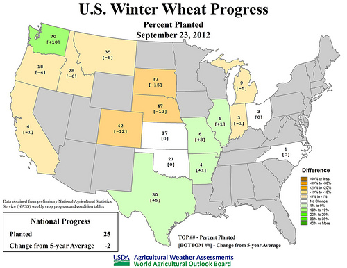
U.S Winter Wheat Progress - Percent Planted as of September 23, 2012
Visit www.usda.gov/drought for the latest information regarding USDA’s Drought Disaster response and assistance.
Based on data since 1995, U.S. corn and soybean harvests are proceeding at a record pace. By September 23, more than one-third (39%) of the corn had been harvested, three times the five-year average of 13%. During the preceding 17 years, the record amount of U.S. corn harvested by September 23 had been 24% in 2000. Similarly, more than one-fifth (22%) of the soybeans had been harvested by September 23. Prior to this year, the record-setting soybean harvest pace by September 23 had been 18% in 2000.
Meanwhile, prospects for U.S. winter wheat have brightened in some areas due to recent and ongoing rainfall. In particular, beneficial rain has fallen from the central and southern Plains into the Ohio Valley. By September 23, one-quarter (25%) of the winter wheat had been planted, two percentage points behind the five-year average. Seeding has been especially slow across the northwestern half of the Plains and portions of the Northwest, as producers continue to await moisture. On the 23rd, wheat planting was more than five percentage points behind average in South Dakota (37% planted versus the average of 52%), Colorado (42 vs. 54%), Nebraska (47 vs. 59%), Montana (35 vs. 43%), and Idaho (28 vs. 34%).
In fact, some of the nation’s driest conditions cover the northwestern half of the Plains. On September 23, Nebraska led the nation with 98% of its rangeland and pastures rated very poor to poor. Overall, 56% of the nation’s rangeland and pastures were rated very poor to poor on the 23rd, down from a peak of 59% in August and early September. In contrast to the poor conditions across much of the western and central U.S., at least half of the pastures were rated good to excellent in Tennessee, along with every Gulf and Atlantic coastal state from Louisiana to Maryland.
Weather Outlook: For the remainder of the week, a slow-moving cold front will generate locally heavy showers and thunderstorms from the central and southern Plains into the mid-Atlantic region. Additional rainfall totals of one to three inches can be expected in the vicinity of the front. Toward week’s end, the front will sag southward and begin to interact with moisture associated with the remnants of former eastern Pacific Hurricane Miriam. As a result, locally heavy showers will develop in the south-central U.S., including parts of Texas. All of the rain will be timely for recently planted winter wheat across the central and southern Plains, the mid-South, and the lower Midwest. Farther north, however, critically dry conditions will persist in key winter wheat production areas of the northern Plains, from Montana to Nebraska. Dryness will also remain a concern in parts of the Northwestern winter wheat belt. Looking ahead to next week, late-season warmth will dominate the West, while near- to below-normal temperatures will prevail in most areas from the Plains to the East Coast. Meanwhile, next week will feature wet weather in the East but little or no precipitation from the Mississippi Valley westward.
Help those impacted by the drought through our Drought Code Sprint. Submit your apps by October 5!
Tags: drought, Environment, NASS, weather update
Interesting article about whether this year’s drought might have been more predictable at http://t.co/WEQtGmr1
Still a research question.