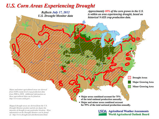
Approximately 88% of the corn grown in the U.S. is within an area experiencing drought, based on historical NASS crop production data. (Click to enlarge map)
Visit www.usda.gov/drought for the latest information regarding USDA’s Drought Disaster response and assistance.
The drought of 2012 has rapidly expanded and intensified, covering 64% of the contiguous United States – according to the U.S. Drought Monitor – by July 17. Three months ago, that figure stood at 37%, and at the beginning of the year, only 28% of the lower 48 states had drought coverage. Read more »

Satellite image with enhanced low cloud-top temperatures for 6:45 a.m. EST (NOAA)
Weekend thundershowers provided limited and localized relief to a few Midwestern fields, but most of the Corn Belt remains in dire need of moisture. Currently, very hot weather is building back into the Midwest. High temperatures above 100°F can be expected in portions of the western Corn Belt for the remainder of the week. The eastern Corn Belt should experience some mid- to late-week heat relief, but only scattered showers will accompany the transition to cooler weather. Like last week, substantial drought relief will be confined to the Southeast. Read more »
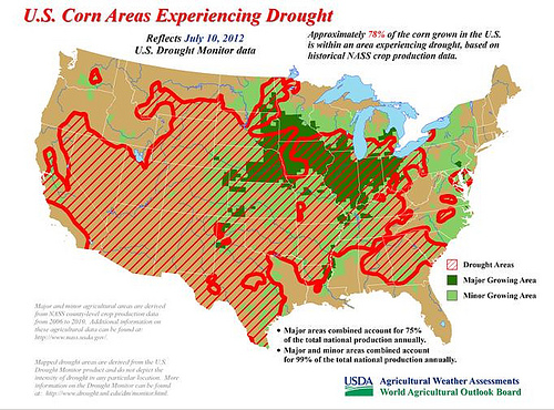
U.S. Corn Areas Experiencing Drought. Reflects July 10, 2012 U.S. (click to enlarge)
On July 11, USDA’s World Agricultural Outlook Board cut the estimate for the 2012 U.S. corn crop by 1.82 billion bushels to “reflect expected impacts of persistent and extreme June and early-July dryness and heat across the central and eastern Corn Belt.” The 12% cut, which left the projected U.S. corn production at 12.97 billion bushels, is a direct result of the nation’s worst drought in a generation—since 1988. Yesterday, Agriculture Secretary Tom Vilsack also announced that more than 1,000 counties across in 26 states would be designated as disaster areas due to the worsening drought. Read more »
No matter where you live in the United States, you’ve probably noticed that the weather just hasn’t been “normal” in recent months. Our nation has experienced widespread flooding, relentless drought, expansive wildfires, and devastating tornadoes – sometimes all at once.
Some of the blame has to be directed at La Niña, a cooling of the waters of the central and eastern equatorial Pacific Ocean. La Niña developed during the summer of 2010, leading to a profound influence on North American weather from the autumn of 2010 through the spring of 2011. In typical fashion, La Niña forced the subtropical jet stream northward, resulting in drought development, expansion, and intensification in the South. At the same, time jet stream disruptions induced by La Niña led to persistently cool, wet conditions across roughly the northern half of the U.S. Read more »