Map
Map of the United States of America : with the contiguous British and Spanish possessions /

| Format |
Map |
|---|---|
| Contributors |
Melish, John |
| Dates |
1816 |
| Location |
United States |
| Language |
English |
| Subjects |
United States |
- Title
- Map of the United States of America : with the contiguous British and Spanish possessions /
- Description
-
Relief shown pictorially.
-
Prime meridians: London and Washington.
-
Seventh state.
-
Includes inset of the West Indies.
-
Available also through the Library of Congress Web site as a raster image.
-
LC copy sectioned and mounted on cloth backing. Includes annotations in pencil.
-
1 map : hand col. ; 88 x 145 cm.
- Creator
- Melish, John,
- Created Published
-
Philadelphia : J. Melish, c1816.
- Subject Headings
-
-
United States
-
-
United States.
- Notes
-
-
Relief shown pictorially.
-
-
Prime meridians: London and Washington.
-
-
Seventh state.
-
-
Includes inset of the West Indies.
-
-
Available also through the Library of Congress Web site as a raster image.
-
-
LC copy sectioned and mounted on cloth backing. Includes annotations in pencil.
- Medium
-
1 map : hand col. ; 88 x 145 cm.
- Call Number
-
G3700 1816 .M4f
- Repository
-
Library of Congress Geography and Map Division Washington, D.C. 20540-4650 USA dcu
- Digital Id
-
g3700 ct000676 http://hdl.loc.gov/loc.gmd/g3700.ct000676
- Library of Congress Catalog Number
- 96686678
Rights & Access
The maps in the Map Collections materials were either published prior to 1922, produced by the United States government, or both (see catalogue records that accompany each map for information regarding date of publication and source). The Library of Congress is providing access to these materials for educational and research purposes and is not aware of any U.S. copyright protection (see Title 17 of the United States Code) or any other restrictions in the Map Collection materials.
Note that the written permission of the copyright owners and/or other rights holders (such as publicity and/or privacy rights) is required for distribution, reproduction, or other use of protected items beyond that allowed by fair use or other statutory exemptions. Responsibility for making an independent legal assessment of an item and securing any necessary permissions ultimately rests with persons desiring to use the item.
More about Copyright and other Restrictions
For guidance about compiling full citations consult Citing Primary Sources.
Part of...
-
Louisiana: European Explorations And The Louisiana Purchase
[77]
-
General Maps
[2477]
-
Geography And Maps Division
[60803]
-
American Memory
[1120694]
More maps like this
-
 Map of the United States of America : with the contiguous British and Spanish possessions /
Contributor:
Melish, John
Site:
American Memory-cultural, Main Catalog
Original Format:
Map
Date:
1819
View catalog record
Map of the United States of America : with the contiguous British and Spanish possessions /
Contributor:
Melish, John
Site:
American Memory-cultural, Main Catalog
Original Format:
Map
Date:
1819
View catalog record
-
 Map of the United States of America : with the contiguous British and Spanish possessions /
Contributor:
Melish, John
Site:
American Memory-cultural, Main Catalog
Original Format:
Map
Date:
1816
View catalog record
Map of the United States of America : with the contiguous British and Spanish possessions /
Contributor:
Melish, John
Site:
American Memory-cultural, Main Catalog
Original Format:
Map
Date:
1816
View catalog record
-
 Map of the United States of America : with the contiguous British and Spanish possessions /
Contributor:
Melish, John
Site:
American Memory-cultural, Main Catalog
Original Format:
Map
Date:
1820
View catalog record
Map of the United States of America : with the contiguous British and Spanish possessions /
Contributor:
Melish, John
Site:
American Memory-cultural, Main Catalog
Original Format:
Map
Date:
1820
View catalog record
-
 Map of the United States of America : with the contiguous British and Spanish possessions /
Contributor:
Melish, John
Site:
American Memory-cultural, Main Catalog
Original Format:
Map
Date:
1816
View catalog record
Map of the United States of America : with the contiguous British and Spanish possessions /
Contributor:
Melish, John
Site:
American Memory-cultural, Main Catalog
Original Format:
Map
Date:
1816
View catalog record
-
 Map of Illinoise [sic] /
Contributor:
Melish, John
Site:
American Memory-cultural, Main Catalog
Original Format:
Map
Date:
1818
View catalog record
Map of Illinoise [sic] /
Contributor:
Melish, John
Site:
American Memory-cultural, Main Catalog
Original Format:
Map
Date:
1818
View catalog record
-
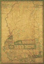 Map of Mississippi : constructed from the surveys in the General Land Office and other documents /
Contributor:
Melish, John
Site:
American Memory-cultural, Main Catalog
Original Format:
Map
Date:
1820
View catalog record
Map of Mississippi : constructed from the surveys in the General Land Office and other documents /
Contributor:
Melish, John
Site:
American Memory-cultural, Main Catalog
Original Format:
Map
Date:
1820
View catalog record
-
 Map of the United States of America : with the contiguous British & Spanish possessions /
Contributor:
Melish, John
Site:
American Memory-cultural, Main Catalog
Original Format:
Map
Date:
1820
View catalog record
Map of the United States of America : with the contiguous British & Spanish possessions /
Contributor:
Melish, John
Site:
American Memory-cultural, Main Catalog
Original Format:
Map
Date:
1820
View catalog record
-
 G. Woolworth Colton's map of the country 500 miles around the city of Washington showing the seat of war in the East
Contributor:
Colton, G. Woolworth
Site:
American Memory-cultural, Main Catalog
Original Format:
Map
Date:
1861
View catalog record
G. Woolworth Colton's map of the country 500 miles around the city of Washington showing the seat of war in the East
Contributor:
Colton, G. Woolworth
Site:
American Memory-cultural, Main Catalog
Original Format:
Map
Date:
1861
View catalog record
-
 Map of the United States of North America, Upper & Lower Canada, New Brunswick, Nova Scotia & British Columbia. Mexico, Cuba, Jamaica, St. Domingo and ...
Contributor:
Ettling, Theodor
Site:
American Memory-cultural, Main Catalog
Original Format:
Map
Date:
1861
View catalog record
Map of the United States of North America, Upper & Lower Canada, New Brunswick, Nova Scotia & British Columbia. Mexico, Cuba, Jamaica, St. Domingo and ...
Contributor:
Ettling, Theodor
Site:
American Memory-cultural, Main Catalog
Original Format:
Map
Date:
1861
View catalog record
-
 Map of the United States : intended chiefly to exhibit the Post Roads & distances.
Contributor:
Bradley, Abraham
Site:
American Memory-cultural, Main Catalog
Original Format:
Map
Date:
1825
View catalog record
Map of the United States : intended chiefly to exhibit the Post Roads & distances.
Contributor:
Bradley, Abraham
Site:
American Memory-cultural, Main Catalog
Original Format:
Map
Date:
1825
View catalog record
-
 Carte de la Louisiane et du cours du Mississipi [i.e. Mississippi]: dressée sur un grand nombre de mémoires entrautres sur ceux de Mr. le Maire ...
Contributor:
L'Isle, Guillaume de
Site:
American Memory-cultural, Main Catalog
Original Format:
Map
Date:
1718
View catalog record
Carte de la Louisiane et du cours du Mississipi [i.e. Mississippi]: dressée sur un grand nombre de mémoires entrautres sur ceux de Mr. le Maire ...
Contributor:
L'Isle, Guillaume de
Site:
American Memory-cultural, Main Catalog
Original Format:
Map
Date:
1718
View catalog record
-
 A new map for travelers through the United States of America showing the railroads, canals & stage roads with the distances,
Contributor:
Smith, J. Calvin
Site:
American Memory-cultural, Main Catalog
Original Format:
Map
Date:
1846
View catalog record
A new map for travelers through the United States of America showing the railroads, canals & stage roads with the distances,
Contributor:
Smith, J. Calvin
Site:
American Memory-cultural, Main Catalog
Original Format:
Map
Date:
1846
View catalog record
-
 A new map of the United States. Upon which are delineated its vast works of internal communication, routes across the continent &c.
Contributor:
Williams, W.
Site:
American Memory-cultural, Main Catalog
Original Format:
Map
Date:
1852
View catalog record
A new map of the United States. Upon which are delineated its vast works of internal communication, routes across the continent &c.
Contributor:
Williams, W.
Site:
American Memory-cultural, Main Catalog
Original Format:
Map
Date:
1852
View catalog record
-
 Phelps's National map of the United States.
Contributor:
Atwood, John M.
Site:
American Memory-cultural, Main Catalog
Original Format:
Map
Date:
1852
View catalog record
Phelps's National map of the United States.
Contributor:
Atwood, John M.
Site:
American Memory-cultural, Main Catalog
Original Format:
Map
Date:
1852
View catalog record
-
 Colton's United States shewing the military stations, forts &c. Entered according to Act of Congress in the year 1855, by J.H. Colton.
Contributor:
Colton, J. H.
Site:
American Memory-cultural, Main Catalog
Original Format:
Map
Date:
1861
View catalog record
Colton's United States shewing the military stations, forts &c. Entered according to Act of Congress in the year 1855, by J.H. Colton.
Contributor:
Colton, J. H.
Site:
American Memory-cultural, Main Catalog
Original Format:
Map
Date:
1861
View catalog record
-
 Map of the United States, and territories.
Contributor:
Mitchell, S. Augustus
Site:
American Memory-cultural, Main Catalog
Original Format:
Map
Date:
1861
View catalog record
Map of the United States, and territories.
Contributor:
Mitchell, S. Augustus
Site:
American Memory-cultural, Main Catalog
Original Format:
Map
Date:
1861
View catalog record
You might also like
-

 The illustrated hand-book, a new guide for travelers through the United States of America ...
Contributor:
Smith, J[ohn] Calvin
Site:
Main Catalog
Original Format:
Book
Date:
1846
The illustrated hand-book, a new guide for travelers through the United States of America ...
Contributor:
Smith, J[ohn] Calvin
Site:
Main Catalog
Original Format:
Book
Date:
1846
-
Youth of famous Americans,
Contributor:
Banks, Louis Albert
Site:
Main Catalog
Original Format:
Book
Date:
1902
-
Hero tales from American history; or, The story of some Americans, who showed that they knew how to live and how to die,
Contributor:
Roosevelt, Theodore
Site:
Main Catalog
Original Format:
Book
Date:
1903
-
Crayon sketches and off-hand takings,
Contributor:
Bungay, George W.
Site:
Main Catalog
Original Format:
Book
Date:
1852
-
Who goes there?
Contributor:
[Bogart, William Henry]
Site:
Main Catalog
Original Format:
Book
Date:
1866
-
A guide to biography for young readers.
Contributor:
Stevenson, Burton Egbert
Site:
Main Catalog
Original Format:
Book
Date:
1910