Map
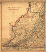
A map of the state of Virginia, constructed in conformity to law from the late surveys authorized by the legislature and other original and authentic documents /

| Format |
Map |
|---|---|
| Contributors |
BöŸE, Herman BöÿE, Herman |
| Dates |
1859 |
| Location |
United States Virginia |
| Language |
English |
| Subjects |
United States Virginia |
- Title
- A map of the state of Virginia, constructed in conformity to law from the late surveys authorized by the legislature and other original and authentic documents /
- Description
-
Relief shown by hachures. Depths shown by soundings.
-
"Entered according to Act of Congress, the 14th day of April 1826, by John Tyler, Governor of the State of Virginia."
-
Prime meridian: Washington.
-
Originally printed on 9 sheets.
-
Includes geological remarks, memoranda, tables of population, altitudes, and steam boat routes, ill., and views of Richmond and the University of Virginia.
-
Available also through the Library of Congress Web site as a raster image.
-
Annotated in colored crayon along some boundaries. DLC
-
1 map on 2 sheets : hand col., sectioned and mounted on cloth ; 155 x 240 cm., sheets 82 x 240 cm.
- Creator
- Böÿe, Herman.
- Created Published
-
[Virginia : s.n., 1859]
- Subject Headings
-
-
Virginia
-
-
United States--Virginia.
- Notes
-
-
Relief shown by hachures. Depths shown by soundings.
-
-
"Entered according to Act of Congress, the 14th day of April 1826, by John Tyler, Governor of the State of Virginia."
-
-
Prime meridian: Washington.
-
-
Originally printed on 9 sheets.
-
-
Includes geological remarks, memoranda, tables of population, altitudes, and steam boat routes, ill., and views of Richmond and the University of Virginia.
-
-
Available also through the Library of Congress Web site as a raster image.
-
-
Annotated in colored crayon along some boundaries. DLC
- Medium
-
1 map on 2 sheets : hand col., sectioned and mounted on cloth ; 155 x 240 cm., sheets 82 x 240 cm.
- Call Number
-
G3880 1859 .B6
- Repository
-
Library of Congress Geography and Map Division Washington, D.C. 20540-4650 USA dcu
- Digital Id
-
g3880 ct001518 http://hdl.loc.gov/loc.gmd/g3880.ct001518
- Library of Congress Catalog Number
- 99439988
Rights & Access
The maps in the Map Collections materials were either published prior to 1922, produced by the United States government, or both (see catalogue records that accompany each map for information regarding date of publication and source). The Library of Congress is providing access to these materials for educational and research purposes and is not aware of any U.S. copyright protection (see Title 17 of the United States Code) or any other restrictions in the Map Collection materials.
Note that the written permission of the copyright owners and/or other rights holders (such as publicity and/or privacy rights) is required for distribution, reproduction, or other use of protected items beyond that allowed by fair use or other statutory exemptions. Responsibility for making an independent legal assessment of an item and securing any necessary permissions ultimately rests with persons desiring to use the item.
More about Copyright and other Restrictions
For guidance about compiling full citations consult Citing Primary Sources.
Part of...
-
General Maps
[2477]
-
Geography And Maps Division
[60803]
-
American Memory
[1120694]
More maps like this
-
 A map of the state of Virginia : reduced from the nine sheet map of the state in conformity to law /
Contributor:
Böÿe, Herman, Böÿe, Herman
Site:
American Memory-cultural, Main Catalog
Original Format:
Map
Date:
1859
View catalog record
A map of the state of Virginia : reduced from the nine sheet map of the state in conformity to law /
Contributor:
Böÿe, Herman, Böÿe, Herman
Site:
American Memory-cultural, Main Catalog
Original Format:
Map
Date:
1859
View catalog record
-
 A new and accurate map of Virginia wherein most of the counties are laid down from actual surveys. With a concise account of the number ...
Contributor:
Henry, John
Site:
American Memory-cultural, Main Catalog
Original Format:
Map
Date:
1770
View catalog record
A new and accurate map of Virginia wherein most of the counties are laid down from actual surveys. With a concise account of the number ...
Contributor:
Henry, John
Site:
American Memory-cultural, Main Catalog
Original Format:
Map
Date:
1770
View catalog record
-
 Map of Loudon [sic], Jefferson, Berkeley, Frederick Counties, Va.
Contributor:
Macomb, J. N.
Site:
American Memory-cultural, Main Catalog
Original Format:
Map
Date:
1862
View catalog record
Map of Loudon [sic], Jefferson, Berkeley, Frederick Counties, Va.
Contributor:
Macomb, J. N.
Site:
American Memory-cultural, Main Catalog
Original Format:
Map
Date:
1862
View catalog record
-
 Central Virginia /
Contributor:
United States. Army. Corps of Topographical Engineers
Site:
American Memory-cultural, Main Catalog
Original Format:
Map
Date:
1864
View catalog record
Central Virginia /
Contributor:
United States. Army. Corps of Topographical Engineers
Site:
American Memory-cultural, Main Catalog
Original Format:
Map
Date:
1864
View catalog record
-
 Operations of the Army of the Potomac, May & June 1864.
Site:
American Memory-cultural, Main Catalog
Original Format:
Map
Date:
1864
View catalog record
Operations of the Army of the Potomac, May & June 1864.
Site:
American Memory-cultural, Main Catalog
Original Format:
Map
Date:
1864
View catalog record
-
 Distances, 1862 : [Virginia].
Site:
American Memory-cultural, Main Catalog
Original Format:
Map
Date:
1862
View catalog record
Distances, 1862 : [Virginia].
Site:
American Memory-cultural, Main Catalog
Original Format:
Map
Date:
1862
View catalog record
-
 Military map refering [sic] to the campaigns of the Army of the Potomac in Virginia, including the adjoining parts of Maryland & Pennsylvania
Contributor:
Bechler, Gustavus R.
Site:
American Memory-cultural, Main Catalog
Original Format:
Map
Date:
1864
View catalog record
Military map refering [sic] to the campaigns of the Army of the Potomac in Virginia, including the adjoining parts of Maryland & Pennsylvania
Contributor:
Bechler, Gustavus R.
Site:
American Memory-cultural, Main Catalog
Original Format:
Map
Date:
1864
View catalog record
-
 Map of western Virginia /
Contributor:
Nicholson, W. L.
Site:
American Memory-cultural, Main Catalog
Original Format:
Map
Date:
1862
View catalog record
Map of western Virginia /
Contributor:
Nicholson, W. L.
Site:
American Memory-cultural, Main Catalog
Original Format:
Map
Date:
1862
View catalog record
-
 A survey of the northern neck of Virginia, being the lands belonging to the Rt. Honourable Thomas Lord Fairfax Baron Cameron, bounded by & within ...
Contributor:
Warner, John
Site:
American Memory-cultural, Main Catalog
Original Format:
Map
Date:
1747
View catalog record
A survey of the northern neck of Virginia, being the lands belonging to the Rt. Honourable Thomas Lord Fairfax Baron Cameron, bounded by & within ...
Contributor:
Warner, John
Site:
American Memory-cultural, Main Catalog
Original Format:
Map
Date:
1747
View catalog record
-
 J. H. Colton's topographical map of the seat of war in Virginia, Maryland &c.
Contributor:
Colton, J. H.
Site:
American Memory-cultural, Main Catalog
Original Format:
Map
Date:
1863
View catalog record
J. H. Colton's topographical map of the seat of war in Virginia, Maryland &c.
Contributor:
Colton, J. H.
Site:
American Memory-cultural, Main Catalog
Original Format:
Map
Date:
1863
View catalog record
-
 Map illustrating General Grant's campaign in Virginia.
Site:
American Memory-cultural, Main Catalog
Original Format:
Map
Date:
1864
View catalog record
Map illustrating General Grant's campaign in Virginia.
Site:
American Memory-cultural, Main Catalog
Original Format:
Map
Date:
1864
View catalog record
-
 Map of middle Virginia /
Contributor:
Hotchkiss, Jedediah
Site:
American Memory-cultural, Main Catalog
Original Format:
Map
Date:
1873
View catalog record
Map of middle Virginia /
Contributor:
Hotchkiss, Jedediah
Site:
American Memory-cultural, Main Catalog
Original Format:
Map
Date:
1873
View catalog record
-
 Military map of south-eastern Virginia /
Contributor:
United States Coast Survey
Site:
American Memory-cultural, Main Catalog
Original Format:
Map
Date:
1862
View catalog record
Military map of south-eastern Virginia /
Contributor:
United States Coast Survey
Site:
American Memory-cultural, Main Catalog
Original Format:
Map
Date:
1862
View catalog record
-
 Map of eastern Virginia /
Contributor:
Nicholson, W. L.
Site:
American Memory-cultural, Main Catalog
Original Format:
Map
Date:
1862
View catalog record
Map of eastern Virginia /
Contributor:
Nicholson, W. L.
Site:
American Memory-cultural, Main Catalog
Original Format:
Map
Date:
1862
View catalog record
You might also like
-
 The Boardwalk, Pine Beach, Va.
Contributor:
Detroit Publishing Co
Site:
Prints & Photographs
Original Format:
Photo, Print, Drawing
Date:
1906
The Boardwalk, Pine Beach, Va.
Contributor:
Detroit Publishing Co
Site:
Prints & Photographs
Original Format:
Photo, Print, Drawing
Date:
1906
-
 Pine Beach Hotel, Pine Beach, Va.
Contributor:
Detroit Publishing Co
Site:
Prints & Photographs
Original Format:
Photo, Print, Drawing
Date:
1906
Pine Beach Hotel, Pine Beach, Va.
Contributor:
Detroit Publishing Co
Site:
Prints & Photographs
Original Format:
Photo, Print, Drawing
Date:
1906
-
 Amusements and boardwalk, Pine Beach, Va.
Contributor:
Detroit Publishing Co
Site:
Prints & Photographs
Original Format:
Photo, Print, Drawing
Date:
1906
Amusements and boardwalk, Pine Beach, Va.
Contributor:
Detroit Publishing Co
Site:
Prints & Photographs
Original Format:
Photo, Print, Drawing
Date:
1906
-
 Pine Beach Hotel, Pine Beach, Va.
Contributor:
Detroit Publishing Co
Site:
Prints & Photographs
Original Format:
Photo, Print, Drawing
Date:
1906
Pine Beach Hotel, Pine Beach, Va.
Contributor:
Detroit Publishing Co
Site:
Prints & Photographs
Original Format:
Photo, Print, Drawing
Date:
1906
-

 Letter from B. W. Leigh, Esq., to the General Assembly of Virginia.
Contributor:
Leigh, Benjamin Watkins
Site:
Main Catalog
Original Format:
Book
Date:
1836
Letter from B. W. Leigh, Esq., to the General Assembly of Virginia.
Contributor:
Leigh, Benjamin Watkins
Site:
Main Catalog
Original Format:
Book
Date:
1836
-
The need for greater consolidation or coordination of workforce development and training resources in the Commonwealth : report of the Joint Subcommittee Studying the Need ...
Site:
Main Catalog
Original Format:
Book
Date:
2006