![[January 18, 1945], HQ Twelfth Army Group situation map.](https://cybercemetery.unt.edu/archive/oilspill/20121025073351im_/http://www.loc.gov/collections/static/world-war-II-maps-military-situation-maps-from-1944-to-1945/images/ict21228.jpg)
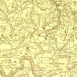
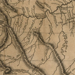
![Sketch-book of positions of forces of 2nd Corps A.N.Va., campaigns of 1864 : [Virginia]](https://cybercemetery.unt.edu/archive/oilspill/20121025073351im_/http://www.loc.gov/collections/static/hotchkiss-maps/images/cwh00003.jpg)
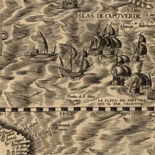
![Plano. I descripcion de la costa, desde el Cavo Cañaveral, hasta cerca de la boca de la Vir[g]inia, contando, costa de Florida, Georgia y Carolinas del S, y N, con todos sus puertos, este[ros ... ]letas, baxos, islas y rios; segun las vlti[mas not]icias, hata [sic] oy Octubre de 1756.](https://cybercemetery.unt.edu/archive/oilspill/20121025073351im_/http://www.loc.gov/collections/static/american-revolutionary-war-maps/images/ct000339.jpg)
Results
-

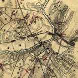
A plan of the city and environs of Philadelphia : with the works and encampments of His Majesty's forces under the command of Lieutenant General ...
Scale ca. 1:21,000.
Contributor: Faden, William Site: American Memory-cultural - Main Catalog Original Format: Map Date: 1779 View catalog record -

[Rough draught of Boston and harbour.
Scale ca. 1:18,500.
Site: American Memory-cultural - Main Catalog Original Format: Map Date: 1776 View catalog record -

A Plan of the Straits of St. Mary, and Michilimakinac, to shew the situation & importance of the two westernmost settlements of Canada for the ...
Scale ca. 1:75,000.
Site: American Memory-cultural - Main Catalog Original Format: Map Date: 1750 View catalog record -

Carte de l'isle de Saint Domingue, pour servir à l'Histoire générale des voyages.
Scale ca. 1:2,700,000.
Contributor: Bellin, Jacques Nicolas Site: American Memory-cultural - Main Catalog Original Format: Map Date: 1758 View catalog record -

To His Excellency Genl. Washington, Commander in Chief of the armies of the United States of America, this plan of the investment of York and ...
Scale ca. 1:14,400.
Contributor: Bauman, Sebastian Site: American Memory-cultural - Main Catalog Original Format: Map Date: 1782 View catalog record -

An accurate map of North America describing and distinguishing the British and French dominions on this great continent according to the definitive treaty concluded at ...
Scale ca. 1:7,000,000.
Contributor: Sayer, Robert Site: American Memory-cultural - Main Catalog Original Format: Map Date: 1763 View catalog record -


Plano de la ciudad de Puerto Real, en la isla de la Jamaica. Catalog Record - Electronic Resource Available
Scale ca. 1:3,300.
Contributor: López, Juan Site: Main Catalog Original Format: Map Date: 1782 -

Yongning xian he tu.
Scale ca. 1:25,000.
Site: American Memory-cultural - Main Catalog Original Format: Map Date: 1754 View catalog record -

Amérique campagne.
Scale not given.
Contributor: Rochambeau, Jean-Baptiste-Donatien de Vimeur Site: American Memory-cultural - Main Catalog Original Format: Map Date: 1782 View catalog record -

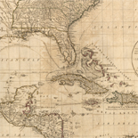
A compleat map of the West Indies containing the coasts of Florida, Louisiana, New Spain, and Terra Firma: With all the islands.
Scale ca. 1:9,000,000.
Contributor: Dunn, Samuel Site: American Memory-cultural - Main Catalog Original Format: Map Date: 1774 View catalog record -

Plano del Puerto de Sn. Miguel y Bahía de Gaston situada en la costa septentrional del Estrecho de Magallanes en latitu. S. de 53p0s42ʹ y ...
Puerto de San Miguel and Bahía de Gaston unidentifiable on modern maps and/or gazetteers.
Contributor: Velmonte, Alexandro Site: American Memory-cultural - Main Catalog Original Format: Map Date: 1700 View catalog record -

Sankai yochi zenzu.
Scale ca. 1:27,000,000 at the equator.
Contributor: Nagakubo, Sekisui Site: American Memory-cultural - Main Catalog Original Format: Map Date: 1785 View catalog record -

[Yŏjido].
Romanized.
Site: American Memory-cultural - Main Catalog Original Format: Map Date: 1700 View catalog record -

La Californie ou Nouvelle Caroline : teatro de los trabajos, Apostolicos de la Compa. e Jesus en la America Septe. /
Relief shown pictorially.
Contributor: Fer, Nicolas de Site: American Memory-cultural - Main Catalog Original Format: Map Date: 1720 View catalog record -

Plan of the city of Washington in the territory of Columbia : ceded by the states of Virginia and Maryland to the United States of ...
Shows block numbers and proposed government buildings.
Contributor: Ellicott, Andrew Site: American Memory-cultural - Main Catalog Original Format: Map Date: 1792 View catalog record -

Plano del Rio Geneyro situado en la latd. S de 23 gs. en longd. 12 en el ste pureto se puede darfon do fuera de ...
Shows Guanabara Bay, including Rio de Janeiro harbor area.
Contributor: Castro, Antonio Gonzales de Site: American Memory-cultural - Main Catalog Original Format: Map Date: 1764 View catalog record -

Dissegno topografo del Canale di Cattaro con il confine de Castelnovo e Risano /
Relief shown pictorially.
Contributor: Grimani, Giouanni Site: American Memory-cultural - Main Catalog Original Format: Map Date: 1701 View catalog record -

Carta de la isla de San Christoval,
Scale ca. 1:68,000.
Contributor: López, Juan - López, Juan Site: American Memory-cultural - Main Catalog Original Format: Map Date: 1780 View catalog record -

Imperii Persici in omnes suas provincias nova tabula geographica /
Relief shown pictorially.
Contributor: Homann, Johann Baptist Site: American Memory-cultural - Main Catalog Original Format: Map Date: 1724 View catalog record -

Puerto de Guárico situado en la latd. de 19p0s48ʹ y en longitud de 304p0s16ʹ.
Depths shown by soundings.
Site: American Memory-cultural - Main Catalog Original Format: Map Date: 1700 View catalog record
Refine your search
Original Format
- Map
- Web Page [1]