Map
New county and railway map of the United States and the Dominion of Canada compiled from information obtained from official sources showing the lines of the Chicago and Alton R.R. and its connections.

| Format |
Map |
|---|---|
| Contributors |
Rand Mcnally And Company |
| Dates |
1883 |
| Location |
American Border Region Canada Mexican United States |
| Language |
English |
| Subjects |
Canada Chicago And Alton Railroad Company Mexican American Border Region Railroads United States |
- Title
- New county and railway map of the United States and the Dominion of Canada compiled from information obtained from official sources showing the lines of the Chicago and Alton R.R. and its connections.
- Description
-
Scale ca. 1:3,500,000.
-
LC Railroad maps, 61
-
Description derived from published bibliography.
-
Shows relief by hachures, drainage, cities and towns, counties, and the railroad network emphasizing the main line. Includes names of lines.
-
Available also through the Library of Congress Web site as a raster image.
-
col. map 96 x 136 cm.
- Creator
- Rand McNally and Company.
- Created Published
-
Chicago, 1883.
- Subject Headings
-
-
Chicago and Alton Railroad Company
-
-
Railroads--United States
-
-
Railroads--Canada
-
-
Railroads--Mexican-American Border Region
-
-
United States.
-
-
Canada.
-
-
Mexican-American Border Region.
- Notes
-
-
Scale ca. 1:3,500,000.
-
-
LC Railroad maps, 61
-
-
Description derived from published bibliography.
-
-
Shows relief by hachures, drainage, cities and towns, counties, and the railroad network emphasizing the main line. Includes names of lines.
-
-
Available also through the Library of Congress Web site as a raster image.
- Medium
-
col. map 96 x 136 cm.
- Call Number
-
G3701.P3 1883 .R33
- Repository
-
Library of Congress Geography and Map Division Washington, D.C. 20540-4650 USA dcu
- Digital Id
-
g3701p rr000610 http://hdl.loc.gov/loc.gmd/g3701p.rr000610
- Library of Congress Catalog Number
- 98688341
Rights & Access
The maps in the Map Collections materials were either published prior to 1922, produced by the United States government, or both (see catalogue records that accompany each map for information regarding date of publication and source). The Library of Congress is providing access to these materials for educational and research purposes and is not aware of any U.S. copyright protection (see Title 17 of the United States Code) or any other restrictions in the Map Collection materials.
Note that the written permission of the copyright owners and/or other rights holders (such as publicity and/or privacy rights) is required for distribution, reproduction, or other use of protected items beyond that allowed by fair use or other statutory exemptions. Responsibility for making an independent legal assessment of an item and securing any necessary permissions ultimately rests with persons desiring to use the item.
More about Copyright and other Restrictions
For guidance about compiling full citations consult Citing Primary Sources.
Part of...
-
Railroad Maps, 1828 1900
[617]
-
Transportation And Communication Cartographic Items
[761]
-
Geography And Maps Division
[60803]
-
American Memory
[1120703]
More maps like this
-
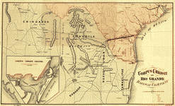 Corpus Christi and Rio Grande Railway Company, [map showing the proposed railroad between Laredo and Corpus Christi and its connections with Mexico].
Contributor:
Bien, Julius
Site:
American Memory-cultural, Main Catalog
Original Format:
Map
Date:
1874
View catalog record
Corpus Christi and Rio Grande Railway Company, [map showing the proposed railroad between Laredo and Corpus Christi and its connections with Mexico].
Contributor:
Bien, Julius
Site:
American Memory-cultural, Main Catalog
Original Format:
Map
Date:
1874
View catalog record
-
 Map of Texas showing the Sabine and Galveston Bay Rail Road, or Texas and New Orleans Air Line Rail Line, its connections in the U.S. ...
Contributor:
Gentry, A. M.
Site:
American Memory-cultural, Main Catalog
Original Format:
Map
Date:
1859
View catalog record
Map of Texas showing the Sabine and Galveston Bay Rail Road, or Texas and New Orleans Air Line Rail Line, its connections in the U.S. ...
Contributor:
Gentry, A. M.
Site:
American Memory-cultural, Main Catalog
Original Format:
Map
Date:
1859
View catalog record
-
 Map of Texas, showing the line of the Texas and New Orleans Rail Road, and its connections in the U.S. and adjacent territories.
Contributor:
Gentry, A. M.
Site:
American Memory-cultural, Main Catalog
Original Format:
Map
Date:
1860
View catalog record
Map of Texas, showing the line of the Texas and New Orleans Rail Road, and its connections in the U.S. and adjacent territories.
Contributor:
Gentry, A. M.
Site:
American Memory-cultural, Main Catalog
Original Format:
Map
Date:
1860
View catalog record
-
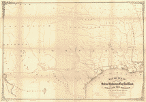
 Map of the Rio Grande and Pecos Railway showing its connections with the Texas Mexican, Texas Mexican Short Line, Mexican National, Texas & St. Louis, ...
Contributor:
Rio Grande and Pecos Railway Co
Site:
American Memory-cultural, Main Catalog
Original Format:
Map
Date:
1882
View catalog record
Map of the Rio Grande and Pecos Railway showing its connections with the Texas Mexican, Texas Mexican Short Line, Mexican National, Texas & St. Louis, ...
Contributor:
Rio Grande and Pecos Railway Co
Site:
American Memory-cultural, Main Catalog
Original Format:
Map
Date:
1882
View catalog record
-
 Rand McNally new official railroad map of the United States and southern Canada.
Contributor:
Rand McNally and Company
Site:
American Memory-cultural, Main Catalog
Original Format:
Map
Date:
1920
View catalog record
Rand McNally new official railroad map of the United States and southern Canada.
Contributor:
Rand McNally and Company
Site:
American Memory-cultural, Main Catalog
Original Format:
Map
Date:
1920
View catalog record
-
 Rand McNally & Co's new railroad and county map of the United States and Canada. Compiled from the latest government surveys, and drawn to an ...
Contributor:
Rand McNally and Company
Site:
American Memory-cultural, Main Catalog
Original Format:
Map
Date:
1876
View catalog record
Rand McNally & Co's new railroad and county map of the United States and Canada. Compiled from the latest government surveys, and drawn to an ...
Contributor:
Rand McNally and Company
Site:
American Memory-cultural, Main Catalog
Original Format:
Map
Date:
1876
View catalog record
-
 The Rand-McNally indexed county and township pocket map and shippers guide of Florida showing all railroads, cities, towns, villages, post offices, lakes, rivers, etc.
Contributor:
Rand McNally and Company
Site:
American Memory-cultural, Main Catalog
Original Format:
Map
Date:
1900
View catalog record
The Rand-McNally indexed county and township pocket map and shippers guide of Florida showing all railroads, cities, towns, villages, post offices, lakes, rivers, etc.
Contributor:
Rand McNally and Company
Site:
American Memory-cultural, Main Catalog
Original Format:
Map
Date:
1900
View catalog record
-
 Correct map of the Burlington and Missouri River R.R., the Burlington Route and its connections.
Contributor:
Rand McNally and Company
Site:
American Memory-cultural, Main Catalog
Original Format:
Map
Date:
1882
View catalog record
Correct map of the Burlington and Missouri River R.R., the Burlington Route and its connections.
Contributor:
Rand McNally and Company
Site:
American Memory-cultural, Main Catalog
Original Format:
Map
Date:
1882
View catalog record
-
 Burlington Route.
Contributor:
Rand McNally and Company
Site:
American Memory-cultural, Main Catalog
Original Format:
Map
Date:
1892
View catalog record
Burlington Route.
Contributor:
Rand McNally and Company
Site:
American Memory-cultural, Main Catalog
Original Format:
Map
Date:
1892
View catalog record
-
 Rand, Mc.Nally & Co's official railroad map of the United States with portions of the Dominion of Canada, the Republic of Mexico, and the West ...
Contributor:
Rand McNally and Company
Site:
American Memory-cultural, Main Catalog
Original Format:
Map
Date:
1893
View catalog record
Rand, Mc.Nally & Co's official railroad map of the United States with portions of the Dominion of Canada, the Republic of Mexico, and the West ...
Contributor:
Rand McNally and Company
Site:
American Memory-cultural, Main Catalog
Original Format:
Map
Date:
1893
View catalog record
-
 Indexed map of Rhode Island showing the railroads in the State, and the express company doing business over each, also counties, townships, lakes, rivers, islands, ...
Contributor:
Rand McNally and Company
Site:
American Memory-cultural, Main Catalog
Original Format:
Map
Date:
1875
View catalog record
Indexed map of Rhode Island showing the railroads in the State, and the express company doing business over each, also counties, townships, lakes, rivers, islands, ...
Contributor:
Rand McNally and Company
Site:
American Memory-cultural, Main Catalog
Original Format:
Map
Date:
1875
View catalog record
-
 South Carolina railroads.
Contributor:
Rand McNally and Company
Site:
American Memory-cultural, Main Catalog
Original Format:
Map
Date:
1900
View catalog record
South Carolina railroads.
Contributor:
Rand McNally and Company
Site:
American Memory-cultural, Main Catalog
Original Format:
Map
Date:
1900
View catalog record
-
 Texas railroads.
Contributor:
Rand McNally and Company
Site:
American Memory-cultural, Main Catalog
Original Format:
Map
Date:
1900
View catalog record
Texas railroads.
Contributor:
Rand McNally and Company
Site:
American Memory-cultural, Main Catalog
Original Format:
Map
Date:
1900
View catalog record
-
 Map of Illinois Central R.R.
Contributor:
Rand McNally and Company
Site:
American Memory-cultural, Main Catalog
Original Format:
Map
Date:
1892
View catalog record
Map of Illinois Central R.R.
Contributor:
Rand McNally and Company
Site:
American Memory-cultural, Main Catalog
Original Format:
Map
Date:
1892
View catalog record
-
 New enlarged scale railroad and county map of California showing every railroad station and post office in the state.
Contributor:
Rand McNally and Company
Site:
American Memory-cultural, Main Catalog
Original Format:
Map
Date:
1883
View catalog record
New enlarged scale railroad and county map of California showing every railroad station and post office in the state.
Contributor:
Rand McNally and Company
Site:
American Memory-cultural, Main Catalog
Original Format:
Map
Date:
1883
View catalog record
-
 The Santa Fé Route and connections, 1888.
Contributor:
Rand McNally and Company
Site:
American Memory-cultural, Main Catalog
Original Format:
Map
Date:
1888
View catalog record
The Santa Fé Route and connections, 1888.
Contributor:
Rand McNally and Company
Site:
American Memory-cultural, Main Catalog
Original Format:
Map
Date:
1888
View catalog record
You might also like
-

 Operation Fast and Furious : reckless decisions, tragic outcomes : hearing before the Committee on Oversight and Government Reform, House of Representatives, One Hundred Twelfth ...
Contributor:
United States. Congress. House. Committee on Oversight and Government Reform
Site:
Main Catalog
Original Format:
Book
Date:
2011-06-15
Operation Fast and Furious : reckless decisions, tragic outcomes : hearing before the Committee on Oversight and Government Reform, House of Representatives, One Hundred Twelfth ...
Contributor:
United States. Congress. House. Committee on Oversight and Government Reform
Site:
Main Catalog
Original Format:
Book
Date:
2011-06-15
-
Armed and dangerous : confronting the problem of border incursions : hearing before the Subcommittee on Investigations of the Committee on Homeland Security, House of ...
Contributor:
United States. Congress. House. Committee on Homeland Security. Subcommittee on Investigations
Site:
Main Catalog
Original Format:
Book
Date:
2006-02-07
-
Unheard voices from the border : a report on environmental justice in the U.S.-Mexico Region from the past to the future.
Contributor:
NEJAC International Roundtable on Environmental Justice on the U.S.-Mexico Border
Site:
Main Catalog
Original Format:
Book
Date:
2003
-
The southern border in crisis : resources and strategies to improve national security : joint hearing before the Subcommittee on Immigration, Border Security, and Citizenship ...
Contributor:
United States. Congress. Senate. Committee on the Judiciary. Subcommittee on Immigration, Border Security, and Citizenship
Site:
Main Catalog
Original Format:
Book
Date:
2005-06-07
-
Federal strategies to end border violence : hearing before the Subcommittee on Terrorism, Technology, and Homeland Security and the Subcommittee on Immigration, Border Security, and ...
Contributor:
United States. Congress. Senate. Committee on the Judiciary. Subcommittee on Terrorism, Technology, and Homeland Security
Site:
Main Catalog
Original Format:
Book
Date:
2006-03-01
-
US/Mexico bi-national performance measures of effectiveness.
Site:
Main Catalog
Original Format:
Book
Date:
1999