Map
Map covering the field of operations of the Army of the Potomac

| Format |
Map |
|---|---|
| Contributors |
Preston, Noble D. |
| Dates |
1905 |
| Location |
United States Virginia |
| Language |
English |
| Subjects |
United States Virginia |
- Title
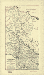
- Map covering the field of operations of the Army of the Potomac
- Description
-
Scale ca. 1:650,000.
-
LC Civil War Maps (2nd ed.), 510.2
-
From History of the Third Pennsylvania Cavalry . . . Philadelphia, Franklin Printing Company, 1905.
-
General map of eastern and central Virginia and part of Maryland showing roads, railroads, and place names. Troop movements are not depicted.
-
Description derived from published bibliography.
-
Available also through the Library of Congress web site as raster image.
-
1 map, 55 x 42 cm.
- Creator
- Preston, Noble D.
- Created Published
-
[S.l., 1905]
- Subject Headings
-
-
Virginia
-
-
United States--Virginia.
- Notes
-
-
Scale ca. 1:650,000.
-
-
LC Civil War Maps (2nd ed.), 510.2
-
-
From History of the Third Pennsylvania Cavalry . . . Philadelphia, Franklin Printing Company, 1905.
-
-
General map of eastern and central Virginia and part of Maryland showing roads, railroads, and place names. Troop movements are not depicted.
-
-
Description derived from published bibliography.
-
-
Available also through the Library of Congress web site as raster image.
- Medium
-
1 map, 55 x 42 cm.
- Call Number
-
G3880 1905 .P7
- Repository
-
Library of Congress Geography and Map Division Washington, D.C. 20540-4650 dcu
- Digital Id
-
g3880 cw0510200 http://hdl.loc.gov/loc.gmd/g3880.cw0510200
- Library of Congress Catalog Number
- 99448899
Rights & Access
The maps in the Map Collections materials were either published prior to 1922, produced by the United States government, or both (see catalogue records that accompany each map for information regarding date of publication and source). The Library of Congress is providing access to these materials for educational and research purposes and is not aware of any U.S. copyright protection (see Title 17 of the United States Code) or any other restrictions in the Map Collection materials.
Note that the written permission of the copyright owners and/or other rights holders (such as publicity and/or privacy rights) is required for distribution, reproduction, or other use of protected items beyond that allowed by fair use or other statutory exemptions. Responsibility for making an independent legal assessment of an item and securing any necessary permissions ultimately rests with persons desiring to use the item.
More about Copyright and other Restrictions
For guidance about compiling full citations consult Citing Primary Sources.
Part of...
-
Civil War Maps
[2281]
-
Military Battles And Campaigns Cartographic Items
[3867]
-
Geography And Maps Division
[60803]
-
American Memory
[1120703]
More maps like this
-
 Route of the Tenth New York Cavalry from Culpeper to Gettysburg and return. Summer and fall campaigns of 1863.
Contributor:
Preston, Noble D.
Site:
American Memory-cultural, Main Catalog
Original Format:
Map
Date:
1863
View catalog record
Route of the Tenth New York Cavalry from Culpeper to Gettysburg and return. Summer and fall campaigns of 1863.
Contributor:
Preston, Noble D.
Site:
American Memory-cultural, Main Catalog
Original Format:
Map
Date:
1863
View catalog record
-
 From Dinwiddie C.H. to Appomattox C.H., route and operations of the 10th New York Cavalry.
Contributor:
Preston, Noble D.
Site:
American Memory-cultural, Main Catalog
Original Format:
Map
Date:
1892
View catalog record
From Dinwiddie C.H. to Appomattox C.H., route and operations of the 10th New York Cavalry.
Contributor:
Preston, Noble D.
Site:
American Memory-cultural, Main Catalog
Original Format:
Map
Date:
1892
View catalog record
-
 Map of a part of the eastern portion of Virginia showing the route of the Cavalry Corps of the Army of the Potomac under Major ...
Contributor:
Preston, Noble D.
Site:
American Memory-cultural, Main Catalog
Original Format:
Map
Date:
1907
View catalog record
Map of a part of the eastern portion of Virginia showing the route of the Cavalry Corps of the Army of the Potomac under Major ...
Contributor:
Preston, Noble D.
Site:
American Memory-cultural, Main Catalog
Original Format:
Map
Date:
1907
View catalog record
-
 Map of a part of the eastern portion of Virginia showing the route of the Cavalry Corps of the Army of the Potomac under Major ...
Contributor:
Preston, Noble D.
Site:
American Memory-cultural, Main Catalog
Original Format:
Map
Date:
1903
View catalog record
Map of a part of the eastern portion of Virginia showing the route of the Cavalry Corps of the Army of the Potomac under Major ...
Contributor:
Preston, Noble D.
Site:
American Memory-cultural, Main Catalog
Original Format:
Map
Date:
1903
View catalog record
-
 Map [of] central Virginia showing the movements of the Tenth New York Cavalry in the campaigs [sic] of 1864.
Contributor:
Preston, Noble D.
Site:
American Memory-cultural, Main Catalog
Original Format:
Map
Date:
1892
View catalog record
Map [of] central Virginia showing the movements of the Tenth New York Cavalry in the campaigs [sic] of 1864.
Contributor:
Preston, Noble D.
Site:
American Memory-cultural, Main Catalog
Original Format:
Map
Date:
1892
View catalog record
-
 Map showing the positions occupied by the Tenth New York Cavalry in the cavalry engagements on the right flank at Gettysburg, Penn. : on July ...
Contributor:
Preston, Noble D.
Site:
American Memory-cultural, Main Catalog
Original Format:
Map
Date:
1863
View catalog record
Map showing the positions occupied by the Tenth New York Cavalry in the cavalry engagements on the right flank at Gettysburg, Penn. : on July ...
Contributor:
Preston, Noble D.
Site:
American Memory-cultural, Main Catalog
Original Format:
Map
Date:
1863
View catalog record
-
 A new and accurate map of Virginia wherein most of the counties are laid down from actual surveys. With a concise account of the number ...
Contributor:
Henry, John
Site:
American Memory-cultural, Main Catalog
Original Format:
Map
Date:
1770
View catalog record
A new and accurate map of Virginia wherein most of the counties are laid down from actual surveys. With a concise account of the number ...
Contributor:
Henry, John
Site:
American Memory-cultural, Main Catalog
Original Format:
Map
Date:
1770
View catalog record
-
 Map of Loudon [sic], Jefferson, Berkeley, Frederick Counties, Va.
Contributor:
Macomb, J. N.
Site:
American Memory-cultural, Main Catalog
Original Format:
Map
Date:
1862
View catalog record
Map of Loudon [sic], Jefferson, Berkeley, Frederick Counties, Va.
Contributor:
Macomb, J. N.
Site:
American Memory-cultural, Main Catalog
Original Format:
Map
Date:
1862
View catalog record
-
 Central Virginia /
Contributor:
United States. Army. Corps of Topographical Engineers
Site:
American Memory-cultural, Main Catalog
Original Format:
Map
Date:
1864
View catalog record
Central Virginia /
Contributor:
United States. Army. Corps of Topographical Engineers
Site:
American Memory-cultural, Main Catalog
Original Format:
Map
Date:
1864
View catalog record
-
 Operations of the Army of the Potomac, May & June 1864.
Site:
American Memory-cultural, Main Catalog
Original Format:
Map
Date:
1864
View catalog record
Operations of the Army of the Potomac, May & June 1864.
Site:
American Memory-cultural, Main Catalog
Original Format:
Map
Date:
1864
View catalog record
-
 Distances, 1862 : [Virginia].
Site:
American Memory-cultural, Main Catalog
Original Format:
Map
Date:
1862
View catalog record
Distances, 1862 : [Virginia].
Site:
American Memory-cultural, Main Catalog
Original Format:
Map
Date:
1862
View catalog record
-
 Military map refering [sic] to the campaigns of the Army of the Potomac in Virginia, including the adjoining parts of Maryland & Pennsylvania
Contributor:
Bechler, Gustavus R.
Site:
American Memory-cultural, Main Catalog
Original Format:
Map
Date:
1864
View catalog record
Military map refering [sic] to the campaigns of the Army of the Potomac in Virginia, including the adjoining parts of Maryland & Pennsylvania
Contributor:
Bechler, Gustavus R.
Site:
American Memory-cultural, Main Catalog
Original Format:
Map
Date:
1864
View catalog record
-
 Map of western Virginia /
Contributor:
Nicholson, W. L.
Site:
American Memory-cultural, Main Catalog
Original Format:
Map
Date:
1862
View catalog record
Map of western Virginia /
Contributor:
Nicholson, W. L.
Site:
American Memory-cultural, Main Catalog
Original Format:
Map
Date:
1862
View catalog record
-
 A survey of the northern neck of Virginia, being the lands belonging to the Rt. Honourable Thomas Lord Fairfax Baron Cameron, bounded by & within ...
Contributor:
Warner, John
Site:
American Memory-cultural, Main Catalog
Original Format:
Map
Date:
1747
View catalog record
A survey of the northern neck of Virginia, being the lands belonging to the Rt. Honourable Thomas Lord Fairfax Baron Cameron, bounded by & within ...
Contributor:
Warner, John
Site:
American Memory-cultural, Main Catalog
Original Format:
Map
Date:
1747
View catalog record
You might also like
-
 The Boardwalk, Pine Beach, Va.
Contributor:
Detroit Publishing Co
Site:
Prints & Photographs
Original Format:
Photo, Print, Drawing
Date:
1906
The Boardwalk, Pine Beach, Va.
Contributor:
Detroit Publishing Co
Site:
Prints & Photographs
Original Format:
Photo, Print, Drawing
Date:
1906
-
 Pine Beach Hotel, Pine Beach, Va.
Contributor:
Detroit Publishing Co
Site:
Prints & Photographs
Original Format:
Photo, Print, Drawing
Date:
1906
Pine Beach Hotel, Pine Beach, Va.
Contributor:
Detroit Publishing Co
Site:
Prints & Photographs
Original Format:
Photo, Print, Drawing
Date:
1906
-
 Amusements and boardwalk, Pine Beach, Va.
Contributor:
Detroit Publishing Co
Site:
Prints & Photographs
Original Format:
Photo, Print, Drawing
Date:
1906
Amusements and boardwalk, Pine Beach, Va.
Contributor:
Detroit Publishing Co
Site:
Prints & Photographs
Original Format:
Photo, Print, Drawing
Date:
1906
-
 Pine Beach Hotel, Pine Beach, Va.
Contributor:
Detroit Publishing Co
Site:
Prints & Photographs
Original Format:
Photo, Print, Drawing
Date:
1906
Pine Beach Hotel, Pine Beach, Va.
Contributor:
Detroit Publishing Co
Site:
Prints & Photographs
Original Format:
Photo, Print, Drawing
Date:
1906
-

 Letter from B. W. Leigh, Esq., to the General Assembly of Virginia.
Contributor:
Leigh, Benjamin Watkins
Site:
Main Catalog
Original Format:
Book
Date:
1836
Letter from B. W. Leigh, Esq., to the General Assembly of Virginia.
Contributor:
Leigh, Benjamin Watkins
Site:
Main Catalog
Original Format:
Book
Date:
1836
-
The need for greater consolidation or coordination of workforce development and training resources in the Commonwealth : report of the Joint Subcommittee Studying the Need ...
Site:
Main Catalog
Original Format:
Book
Date:
2006