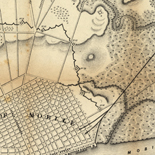


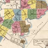
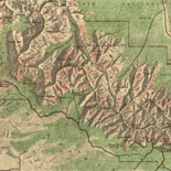
![Sketch-book of positions of forces of 2nd Corps A.N.Va., campaigns of 1864 : [Virginia]](https://cybercemetery.unt.edu/archive/oilspill/20121101150347im_/http://www.loc.gov/collections/static/hotchkiss-maps/images/cwh00003.jpg)

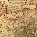
![[Map of parts of Caroline, Hanover, and Henrico counties, Va. west of the Mattaponi River and the Richmond, Fredericksburg, and Potomac Railroad].](https://cybercemetery.unt.edu/archive/oilspill/20121101150347im_/http://www.loc.gov/collections/static/hotchkiss-maps/images/cwh00025.jpg)


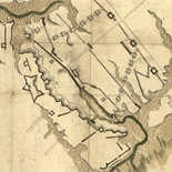
![[Detailed map of part of Virginia from Alexandria to the Potomac River above Washington, D.C. 1886].](https://cybercemetery.unt.edu/archive/oilspill/20121101150347im_/http://www.loc.gov/collections/static/civil-war-maps/images/cw0523000.jpg)


Results
-

Union and Confederate campaigns in the lower Shenandoah Valley illustrated : twenty years after : at the first reunion of Sheridan's veterans on the fields ...
Shows positions of Federal and Confederate armies.
Contributor: Whitney, William H. Site: American Memory-cultural - Main Catalog Original Format: Map Date: 1883 View catalog record -


ADC's street map of Stafford County, Virginia. Catalog Record Only
Cover title.
Contributor: ADC (Firm) Site: Main Catalog Original Format: Map Date: 1989 -
Simple Bouguer gravity anomaly map of the ... Virginia / Catalog Record Only
Some maps prepared in cooperation with the North Carolina Department of Natural Resources and Community Development, Division of Land Resources, Geological Survey Section.
Contributor: Virginia. Division of Mineral Resources Site: Main Catalog Original Format: Map Date: 1980 -

Plan of the Union and Rebel position at Yorktown, Va., April 7th, 1862.
NOTE: Researchers will be served a color photocopy of this scrapbook image.
Contributor: Sneden, Robert Knox Site: American Memory-cultural Original Format: Map Date: 1870 -
Prince William County, Virginia, street map book. Catalog Record Only
Title from cover.
Contributor: ADC (Firm) Site: Main Catalog Original Format: Map Date: 2003 -

Plan of the tunnel and vicinity [of Libby Prison, Richmond, Va.].
NOTE: Researchers will be served a color photocopy of this diary page.
Contributor: Sneden, Robert Knox Site: American Memory-cultural Original Format: Map Date: 1861 -

A map of General Washington's farm of Mount Vernon from a drawing transmitted by the General.
Removed from: Letters from His Excellency George Washington, to Arthur Young, [etc.]. London, 1801. Opp. p. (E312.75.A27 Rare Book Rm.)
Contributor: Washington, George Site: American Memory-cultural - Main Catalog Original Format: Map Date: 1801 View catalog record -
Flood plain management studies status map, Virginia : October 1, 1981 / Catalog Record Only
Indexed.
Contributor: United States. Soil Conservation Service Site: Main Catalog Original Format: Map Date: 1981-10-01 -
Traffic flow map, interstate, arterial, and primary routes, annual average 24-hour traffic-year ending Dec. 31, 1975, Commonwealth of Virginia. Catalog Record Only
Scale ca. 1:1,000,000.
Contributor: Virginia. Traffic and Safety Division Site: Main Catalog Original Format: Map Date: 1976 -
Virginia RoadMap : including vicinity maps of Blacksburg, Bristol, Charlottesville ... Waynesboro, Winchester, Wise / Catalog Record Only
Title from panel.
Contributor: Universal Map (Firm) Site: Main Catalog Original Format: Map Date: 2001 -

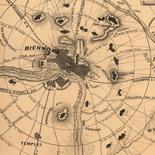
Map of the defences [sic] of Richmond, Va., April 1865.
NOTE: Researchers will be served a color photocopy of this diary page.
Contributor: Sneden, Robert Knox Site: American Memory-cultural Original Format: Map Date: 1861 -
The greater Washington's Garden City, Fairfax Co., Virginia, 1907. Catalog Record Only
Covers area near Franconia Station in Fairfax County, south of Franconia Rd. between Beulah St. and the Richmond, Fredericksburg, and Potomac Railroad.
Contributor: Lang, John C. Site: Main Catalog Original Format: Map Date: 1907 -

Williamsburg to White House
Scale ca. 1:63,630.
Contributor: Abbot, Henry L. Site: American Memory-cultural - Main Catalog Original Format: Map Date: 1862 View catalog record -
Virginia winery guide 2011. Catalog Record Only
Title from panel.
Contributor: Virginia Wine Marketing Office Site: Main Catalog Original Format: Map Date: 2011 -
Norfolk, Hampton, street map : including portions of Chesapeake, Newport News, Portsmouth, Virginia Beach, plus highway map of Norfolk and vicinity. Catalog Record Only
Panel title.
Contributor: H.M. Gousha Company Site: Main Catalog Original Format: Map Date: 1985 -
Traffic flow map, interstate, arterial, and primary routes, annual average 24-hour traffic, Commonwealth of Virginia. Catalog Record Only
Scale ca. 1:1,000,000.
Contributor: Virginia. Traffic and Safety Division Site: Main Catalog Original Format: Map Date: 1973 -
Chesapeake Bay Bridge-Tunnel, award-winning engineering marvel, East Coast map inside : follow the gulls 13, the 17-mile link between Virginia Beach-Norfolk and Virginia's Eastern Shore ... Catalog Record Only
Title from panel.
Contributor: ADC (Firm) Site: Main Catalog Original Format: Map Date: 2006 -

The battle fields and military positions in the Virginian Peninsula, from surveys supplied by officers of the army
Scale ca. 1:375,000.
Contributor: Heald, D. A. Site: American Memory-cultural - Main Catalog Original Format: Map Date: 1862 View catalog record -
DASH transit map, city of Alexandria, Virginia / Catalog Record Only
Panel title: DASH transit routes and schedules : effective March 1, 1987.
Contributor: Alexandria Transit Company Site: Main Catalog Original Format: Map Date: 1987 -
Fredericksburg folio, Virginia-Maryland / Catalog Record Only
5 p. : ill. ; 55 x 47 cm.
Contributor: Darton, Nelson Horatio Site: Main Catalog Original Format: Map Date: 1894
Refine your search
Original Format
- Map
Online Format
Contributor
- Adc (Firm) [235]
- Sneden, Robert Knox [204]
- Hotchkiss, Jedediah [106]
- Rand Mcnally And Company [54]
- Alexandria Drafting Company [51]
- United States. Soil Conservation Service [49]
- Fairfax County (Va.). Division of Mapping [41]
- Michler, N. [39]
- Fairfax County (Va.). Office of Communications. Large Area Mapping [35]
- Smith, John [34]
-
More Contributors