Map
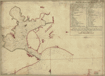
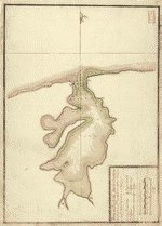
Plano del puerto de la Havana, situado en la parte del N. de la ysla de Cuba en la lattd. de 23p0s10ʹ y en longd. astronómica de 293p0s47ʹ, meridiano de Tenerife ... el año de 1783 por Dn. Josef de Sn. Martin, the. de Navio de la Rl. Armada ...
| Format |
Map |
|---|---|
| Contributors |
Boto Villa, Josef |
| Dates |
1790 |
| Location |
Cuba Havana Bay |
| Language |
Castilian Spanish |
| Subjects |
Coasts Cuba Havana Bay Havana Bay (Cuba) Maps |
- Title
- Plano del puerto de la Havana, situado en la parte del N. de la ysla de Cuba en la lattd. de 23p0s10ʹ y en longd. astronómica de 293p0s47ʹ, meridiano de Tenerife ... el año de 1783 por Dn. Josef de Sn. Martin, the. de Navio de la Rl. Armada ...
- Description
-
Scale ca. 1:16,000.
-
Manuscript, pen-and-ink and red and yellow watercolors.
-
Watermark: Beehive.
-
Depths shown by soundings.
-
Oriented with north to the bottom.
-
Mounted on cloth backing.
-
LC Maps of North America, 1750-1789, 1820
-
LC Luso-Hispanic World, 353
-
Available also through the Library of Congress Web site as a raster image.
-
Indexed.
-
Maggs number annotated in pencil in lower right corner: 105.
-
col. map 45 x 62 cm.
- Creator
- Boto Villa, Josef.
- Created Published
-
[1790]
- Subject Headings
-
-
Havana Bay (Cuba)--Maps
-
-
Coasts--Cuba--Havana Bay--Maps
-
-
Cuba--Havana Bay.
- Notes
-
-
Scale ca. 1:16,000.
-
-
Manuscript, pen-and-ink and red and yellow watercolors.
-
-
Watermark: Beehive.
-
-
Depths shown by soundings.
-
-
Oriented with north to the bottom.
-
-
Mounted on cloth backing.
-
-
LC Maps of North America, 1750-1789, 1820
-
-
LC Luso-Hispanic World, 353
-
-
Available also through the Library of Congress Web site as a raster image.
-
-
Indexed.
-
-
Maggs number annotated in pencil in lower right corner: 105.
- Medium
-
col. map 45 x 62 cm.
- Call Number
-
G4922.H3 1783 .B6
- Repository
-
Library of Congress Geography and Map Division Washington, D.C. 20540-4650 USA dcu
- Digital Id
-
g4922h ar182000 http://hdl.loc.gov/loc.gmd/g4922h.ar182000
- Library of Congress Catalog Number
- 74690699
Rights & Access
The maps in the Map Collections materials were either published prior to 1922, produced by the United States government, or both (see catalogue records that accompany each map for information regarding date of publication and source). The Library of Congress is providing access to these materials for educational and research purposes and is not aware of any U.S. copyright protection (see Title 17 of the United States Code) or any other restrictions in the Map Collection materials.
Note that the written permission of the copyright owners and/or other rights holders (such as publicity and/or privacy rights) is required for distribution, reproduction, or other use of protected items beyond that allowed by fair use or other statutory exemptions. Responsibility for making an independent legal assessment of an item and securing any necessary permissions ultimately rests with persons desiring to use the item.
More about Copyright and other Restrictions
For guidance about compiling full citations consult Citing Primary Sources.
Part of...
More maps like this
-
 Plano del Puerto de la Havana /
Contributor:
González, Pedro, González, Pedro
Site:
American Memory-cultural, Main Catalog
Original Format:
Map
Date:
1791
View catalog record
Plano del Puerto de la Havana /
Contributor:
González, Pedro, González, Pedro
Site:
American Memory-cultural, Main Catalog
Original Format:
Map
Date:
1791
View catalog record
-
 Plano del Puerto de Sn. Christobal de la Habana situado en la costa del N. de la ysla de Cuba en la latd. de 23 ...
Site:
American Memory-cultural, Main Catalog
Original Format:
Map
Date:
1791
View catalog record
Plano del Puerto de Sn. Christobal de la Habana situado en la costa del N. de la ysla de Cuba en la latd. de 23 ...
Site:
American Memory-cultural, Main Catalog
Original Format:
Map
Date:
1791
View catalog record
-
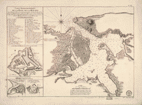 Carte hydrographique de la baye de la Havana. Avec le Plan de la ville et de ses forts pour joindre a la Carte de l'isle ...
Contributor:
Bellin, Jacques Nicolas
Site:
American Memory-cultural, Main Catalog
Original Format:
Map
Date:
1791
View catalog record
Carte hydrographique de la baye de la Havana. Avec le Plan de la ville et de ses forts pour joindre a la Carte de l'isle ...
Contributor:
Bellin, Jacques Nicolas
Site:
American Memory-cultural, Main Catalog
Original Format:
Map
Date:
1791
View catalog record
-
 [Costa de Cuba desde Cabo de San Antonio a la bahía de Cardenas].
Site:
American Memory-cultural, Main Catalog
Original Format:
Map
Date:
1780
View catalog record
[Costa de Cuba desde Cabo de San Antonio a la bahía de Cardenas].
Site:
American Memory-cultural, Main Catalog
Original Format:
Map
Date:
1780
View catalog record
-
 Carta esférica de la parte meridional de la ysla de Cuba /
Contributor:
Rio, José del, Rio, José del
Site:
American Memory-cultural, Main Catalog
Original Format:
Map
Date:
1804
View catalog record
Carta esférica de la parte meridional de la ysla de Cuba /
Contributor:
Rio, José del, Rio, José del
Site:
American Memory-cultural, Main Catalog
Original Format:
Map
Date:
1804
View catalog record
-
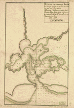
 Plano del puertecito de la Chorrera cituado una legua al O. de la Havana.
Contributor:
San Martín Suárez, José de, San Martín Suárez, José de
Site:
American Memory-cultural, Main Catalog
Original Format:
Map
Date:
1783
View catalog record
Plano del puertecito de la Chorrera cituado una legua al O. de la Havana.
Contributor:
San Martín Suárez, José de, San Martín Suárez, José de
Site:
American Memory-cultural, Main Catalog
Original Format:
Map
Date:
1783
View catalog record
-
 Plano del puertecito de la Chorrera situado una legua al O. de la Havana.
Contributor:
Morete, Diego
Site:
American Memory-cultural, Main Catalog
Original Format:
Map
Date:
1786
View catalog record
Plano del puertecito de la Chorrera situado una legua al O. de la Havana.
Contributor:
Morete, Diego
Site:
American Memory-cultural, Main Catalog
Original Format:
Map
Date:
1786
View catalog record
-
 Plano de la hermosa Bahía de Naranjos situada en la costa del norte de la ysla de Sn. Tiago de Cuva;
Contributor:
Gomez, Joachin Joseph
Site:
American Memory-cultural, Main Catalog
Original Format:
Map
Date:
1787
View catalog record
Plano de la hermosa Bahía de Naranjos situada en la costa del norte de la ysla de Sn. Tiago de Cuva;
Contributor:
Gomez, Joachin Joseph
Site:
American Memory-cultural, Main Catalog
Original Format:
Map
Date:
1787
View catalog record
-
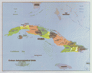 Cuban administrative units.
Contributor:
United States. Central Intelligence Agency
Site:
American Memory-cultural, Main Catalog
Original Format:
Map
Date:
1986
View catalog record
Cuban administrative units.
Contributor:
United States. Central Intelligence Agency
Site:
American Memory-cultural, Main Catalog
Original Format:
Map
Date:
1986
View catalog record
-
 Plano del Puerto de Matanzas situado en la costa del norte de la ysla de Cuba en 23p0s 10 ms. de latd. N. y en ...
Site:
American Memory-cultural, Main Catalog
Original Format:
Map
Date:
1700
View catalog record
Plano del Puerto de Matanzas situado en la costa del norte de la ysla de Cuba en 23p0s 10 ms. de latd. N. y en ...
Site:
American Memory-cultural, Main Catalog
Original Format:
Map
Date:
1700
View catalog record
-
 Plano del Puerto de Matanzas situado en la costa del norte de la ysla de Cuba en 23 gs. 10 ms. de latd. norte y ...
Site:
American Memory-cultural, Main Catalog
Original Format:
Map
Date:
1700
View catalog record
Plano del Puerto de Matanzas situado en la costa del norte de la ysla de Cuba en 23 gs. 10 ms. de latd. norte y ...
Site:
American Memory-cultural, Main Catalog
Original Format:
Map
Date:
1700
View catalog record
-
 Plano del Puerto del Mariel cituado en la costa del N. de la ya. de la Hava. en la latd. N. de 23p0s5ʹ y en ...
Site:
American Memory-cultural, Main Catalog
Original Format:
Map
Date:
1700
View catalog record
Plano del Puerto del Mariel cituado en la costa del N. de la ya. de la Hava. en la latd. N. de 23p0s5ʹ y en ...
Site:
American Memory-cultural, Main Catalog
Original Format:
Map
Date:
1700
View catalog record
-
 Plano de el Puerto de Nipe situado en la costa del N. de la ya. de la Hava. en latd. de 21 gs. 10 ms. ...
Site:
American Memory-cultural, Main Catalog
Original Format:
Map
Date:
1713
View catalog record
Plano de el Puerto de Nipe situado en la costa del N. de la ya. de la Hava. en latd. de 21 gs. 10 ms. ...
Site:
American Memory-cultural, Main Catalog
Original Format:
Map
Date:
1713
View catalog record
-
 Plano del Puertto [sic] de Baracoa cituado en la costa del N. de la ysla de la Havana (a la entrada de la canal vieja) ...
Site:
American Memory-cultural, Main Catalog
Original Format:
Map
Date:
1700
View catalog record
Plano del Puertto [sic] de Baracoa cituado en la costa del N. de la ysla de la Havana (a la entrada de la canal vieja) ...
Site:
American Memory-cultural, Main Catalog
Original Format:
Map
Date:
1700
View catalog record
-
 Plano del Puerto de Baracoa cituado en la costa del N. de la ysla de la Havana (a la entrada de la canal vieja) en ...
Site:
American Memory-cultural, Main Catalog
Original Format:
Map
Date:
1700
View catalog record
Plano del Puerto de Baracoa cituado en la costa del N. de la ysla de la Havana (a la entrada de la canal vieja) en ...
Site:
American Memory-cultural, Main Catalog
Original Format:
Map
Date:
1700
View catalog record
-
 Plano del Puerto del Mariel situado en la costa del N. de la ysla de Cuba en la latd. 23p0s5ʹ y en la longd. 293p0s16ʹ ...
Contributor:
Muñoz, Bernabe, Muñoz, Bernabe
Site:
American Memory-cultural, Main Catalog
Original Format:
Map
Date:
1797
View catalog record
Plano del Puerto del Mariel situado en la costa del N. de la ysla de Cuba en la latd. 23p0s5ʹ y en la longd. 293p0s16ʹ ...
Contributor:
Muñoz, Bernabe, Muñoz, Bernabe
Site:
American Memory-cultural, Main Catalog
Original Format:
Map
Date:
1797
View catalog record
You might also like
-
 A view of the city of the Havana, taken from the road near Colonel Howe's battery Vue de la ville de la Havane prise du ...
Contributor:
Sandby, Paul, Durnford, Elias Walker, Rooker, Edward
Site:
Prints & Photographs, Main Catalog
Original Format:
Photo, Print, Drawing
Date:
1768
View catalog record
A view of the city of the Havana, taken from the road near Colonel Howe's battery Vue de la ville de la Havane prise du ...
Contributor:
Sandby, Paul, Durnford, Elias Walker, Rooker, Edward
Site:
Prints & Photographs, Main Catalog
Original Format:
Photo, Print, Drawing
Date:
1768
View catalog record
-
 [Pictorial newsmap illustrating the U.S. naval blockade during the Cuban Missile Crisis in 1962]
Site:
Prints & Photographs, Main Catalog
Original Format:
Photo, Print, Drawing
Date:
1962
View catalog record
[Pictorial newsmap illustrating the U.S. naval blockade during the Cuban Missile Crisis in 1962]
Site:
Prints & Photographs, Main Catalog
Original Format:
Photo, Print, Drawing
Date:
1962
View catalog record
-
 Album pintoresco de la isla de Cuba
Contributor:
B. May y Ca, Storch & Kramer, Jay I. Kislak Collection (Library of Congress) DLC
Site:
Prints & Photographs
Original Format:
Photo, Print, Drawing
Date:
1855
Album pintoresco de la isla de Cuba
Contributor:
B. May y Ca, Storch & Kramer, Jay I. Kislak Collection (Library of Congress) DLC
Site:
Prints & Photographs
Original Format:
Photo, Print, Drawing
Date:
1855
-
 VIT, Havanna 1978
Contributor:
Santha
Site:
Prints & Photographs
Original Format:
Photo, Print, Drawing
Date:
1978
VIT, Havanna 1978
Contributor:
Santha
Site:
Prints & Photographs
Original Format:
Photo, Print, Drawing
Date:
1978
-

 Under three flags in Cuba; a personal account of the Cuban insurrection and Spanish-American war,
Contributor:
Musgrave, George Clarke
Site:
Main Catalog
Original Format:
Book
Date:
1899
Under three flags in Cuba; a personal account of the Cuban insurrection and Spanish-American war,
Contributor:
Musgrave, George Clarke
Site:
Main Catalog
Original Format:
Book
Date:
1899
-