Map
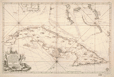
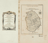
Isle de Cube.

| Format |
Map |
|---|---|
| Contributors |
Bellin, Jacques Nicolas |
| Dates |
1764 |
| Location |
Cuba |
| Language |
French |
| Subjects |
Cuba |
- Title
- Isle de Cube.
- Description
-
Scale ca. 1:3,400,000.
-
Relief shown pictorially. Depths shown by soundings.
-
LC Maps of North America, 1750-1789, 1783
-
"Tome I, no. 50."
-
Appears in the author's Le petit atlas maritime. 1764.
-
Available also through the Library of Congress Web site as a raster image.
-
map 20 x 31 cm.
- Creator
- Bellin, Jacques Nicolas,
- Created Published
-
[Paris, 1764]
- Subject Headings
-
-
Cuba
-
-
Cuba.
- Notes
-
-
Scale ca. 1:3,400,000.
-
-
Relief shown pictorially. Depths shown by soundings.
-
-
LC Maps of North America, 1750-1789, 1783
-
-
"Tome I, no. 50."
-
-
Appears in the author's Le petit atlas maritime. 1764.
-
-
Available also through the Library of Congress Web site as a raster image.
- Medium
-
map 20 x 31 cm.
- Call Number
-
G4920 1764 .B4
- Repository
-
Library of Congress Geography and Map Division Washington, D.C. 20540-4650 USA dcu
- Digital Id
-
g4920 ar178300 http://hdl.loc.gov/loc.gmd/g4920.ar178300
- Library of Congress Catalog Number
- 73697699
Rights & Access
The maps in the Map Collections materials were either published prior to 1922, produced by the United States government, or both (see catalogue records that accompany each map for information regarding date of publication and source). The Library of Congress is providing access to these materials for educational and research purposes and is not aware of any U.S. copyright protection (see Title 17 of the United States Code) or any other restrictions in the Map Collection materials.
Note that the written permission of the copyright owners and/or other rights holders (such as publicity and/or privacy rights) is required for distribution, reproduction, or other use of protected items beyond that allowed by fair use or other statutory exemptions. Responsibility for making an independent legal assessment of an item and securing any necessary permissions ultimately rests with persons desiring to use the item.
More about Copyright and other Restrictions
For guidance about compiling full citations consult Citing Primary Sources.
Part of...
More maps like this
-
 Carte réduite de l'isle de Cube.
Contributor:
Bellin, Jacques Nicolas
Site:
American Memory-cultural, Main Catalog
Original Format:
Map
Date:
1807
View catalog record
Carte réduite de l'isle de Cube.
Contributor:
Bellin, Jacques Nicolas
Site:
American Memory-cultural, Main Catalog
Original Format:
Map
Date:
1807
View catalog record
-
 Baye de Matance dans l'isle de Cube.
Contributor:
Bellin, Jacques Nicolas
Site:
American Memory-cultural, Main Catalog
Original Format:
Map
Date:
1764
View catalog record
Baye de Matance dans l'isle de Cube.
Contributor:
Bellin, Jacques Nicolas
Site:
American Memory-cultural, Main Catalog
Original Format:
Map
Date:
1764
View catalog record
-
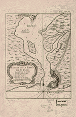
 Plan de la baye de St. Yago dans l'isle de Cube.
Contributor:
Bellin, Jacques Nicolas
Site:
American Memory-cultural, Main Catalog
Original Format:
Map
Date:
1764
View catalog record
Plan de la baye de St. Yago dans l'isle de Cube.
Contributor:
Bellin, Jacques Nicolas
Site:
American Memory-cultural, Main Catalog
Original Format:
Map
Date:
1764
View catalog record
-
 Entrée de la baye de St. Yago dans l'isle de Cube.
Contributor:
Bellin, Jacques Nicolas
Site:
American Memory-cultural, Main Catalog
Original Format:
Map
Date:
1764
View catalog record
Entrée de la baye de St. Yago dans l'isle de Cube.
Contributor:
Bellin, Jacques Nicolas
Site:
American Memory-cultural, Main Catalog
Original Format:
Map
Date:
1764
View catalog record
-
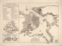 Carte hydrographique de la baye de la Havana. Avec le Plan de la ville et de ses forts pour joindre a la Carte de l'isle ...
Contributor:
Bellin, Jacques Nicolas
Site:
American Memory-cultural, Main Catalog
Original Format:
Map
Date:
1791
View catalog record
Carte hydrographique de la baye de la Havana. Avec le Plan de la ville et de ses forts pour joindre a la Carte de l'isle ...
Contributor:
Bellin, Jacques Nicolas
Site:
American Memory-cultural, Main Catalog
Original Format:
Map
Date:
1791
View catalog record
-

 Plan des havres de Port Antonio et de Saint Francois : situés a la coste du nord est de l'isle de la Jamaique.
Contributor:
Bellin, Jacques Nicolas
Site:
Main Catalog
Original Format:
Map
Date:
1764
Plan des havres de Port Antonio et de Saint Francois : situés a la coste du nord est de l'isle de la Jamaique.
Contributor:
Bellin, Jacques Nicolas
Site:
Main Catalog
Original Format:
Map
Date:
1764
-
 Carte de l'isle de Saint Domingue.
Contributor:
Bellin, Jacques Nicolas
Site:
American Memory-cultural, Main Catalog
Original Format:
Map
Date:
1764
View catalog record
Carte de l'isle de Saint Domingue.
Contributor:
Bellin, Jacques Nicolas
Site:
American Memory-cultural, Main Catalog
Original Format:
Map
Date:
1764
View catalog record
-
 Plan de la Baye Saint Louis dans l'isle de St. Domingue.
Contributor:
Bellin, Jacques Nicolas
Site:
American Memory-cultural, Main Catalog
Original Format:
Map
Date:
1764
View catalog record
Plan de la Baye Saint Louis dans l'isle de St. Domingue.
Contributor:
Bellin, Jacques Nicolas
Site:
American Memory-cultural, Main Catalog
Original Format:
Map
Date:
1764
View catalog record
-
 Plan de l'isle à Vache à la coste de sud de S. Domingue.
Contributor:
Bellin, Jacques Nicolas
Site:
American Memory-cultural, Main Catalog
Original Format:
Map
Date:
1764
View catalog record
Plan de l'isle à Vache à la coste de sud de S. Domingue.
Contributor:
Bellin, Jacques Nicolas
Site:
American Memory-cultural, Main Catalog
Original Format:
Map
Date:
1764
View catalog record
-
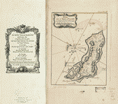
 Carte de l'isle de Nieves.
Contributor:
Bellin, Jacques Nicolas
Site:
American Memory-cultural, Main Catalog
Original Format:
Map
Date:
1764
View catalog record
Carte de l'isle de Nieves.
Contributor:
Bellin, Jacques Nicolas
Site:
American Memory-cultural, Main Catalog
Original Format:
Map
Date:
1764
View catalog record
-
 Karte von dem Mexicanischen Meerbusen und dem Inseln von America, zur Allgemeinen Historie der Reisen.
Contributor:
Bellin, Jacques Nicolas
Site:
American Memory-cultural, Main Catalog
Original Format:
Map
Date:
1754
View catalog record
Karte von dem Mexicanischen Meerbusen und dem Inseln von America, zur Allgemeinen Historie der Reisen.
Contributor:
Bellin, Jacques Nicolas
Site:
American Memory-cultural, Main Catalog
Original Format:
Map
Date:
1754
View catalog record
-
 Ville du Cap dans l'isle de St. Domingue.
Contributor:
Bellin, Jacques Nicolas
Site:
American Memory-cultural, Main Catalog
Original Format:
Map
Date:
1764
View catalog record
Ville du Cap dans l'isle de St. Domingue.
Contributor:
Bellin, Jacques Nicolas
Site:
American Memory-cultural, Main Catalog
Original Format:
Map
Date:
1764
View catalog record
-
 Carte des environs du Cap François et des paroisses qui en dependent.
Contributor:
Bellin, Jacques Nicolas
Site:
American Memory-cultural, Main Catalog
Original Format:
Map
Date:
1764
View catalog record
Carte des environs du Cap François et des paroisses qui en dependent.
Contributor:
Bellin, Jacques Nicolas
Site:
American Memory-cultural, Main Catalog
Original Format:
Map
Date:
1764
View catalog record
-
 Carte de l'isle de la Jamaique.
Contributor:
Bellin, Jacques Nicolas
Site:
American Memory-cultural, Main Catalog
Original Format:
Map
Date:
1758
View catalog record
Carte de l'isle de la Jamaique.
Contributor:
Bellin, Jacques Nicolas
Site:
American Memory-cultural, Main Catalog
Original Format:
Map
Date:
1758
View catalog record
-
 Carte des royaumes de Siam, de Tunquin, Pegu, Ava Aracan, &c.
Contributor:
Bellin, Jacques Nicolas
Site:
American Memory-cultural, Main Catalog
Original Format:
Map
Date:
1764
View catalog record
Carte des royaumes de Siam, de Tunquin, Pegu, Ava Aracan, &c.
Contributor:
Bellin, Jacques Nicolas
Site:
American Memory-cultural, Main Catalog
Original Format:
Map
Date:
1764
View catalog record
-
 Partie occidentale de la Nouvelle France ou Canada.
Contributor:
Bellin, Jacques Nicolas
Site:
American Memory-cultural, Main Catalog
Original Format:
Map
Date:
1755
View catalog record
Partie occidentale de la Nouvelle France ou Canada.
Contributor:
Bellin, Jacques Nicolas
Site:
American Memory-cultural, Main Catalog
Original Format:
Map
Date:
1755
View catalog record
You might also like
-
 Under three flags in Cuba; a personal account of the Cuban insurrection and Spanish-American war,
Contributor:
Musgrave, George Clarke
Site:
Main Catalog
Original Format:
Book
Date:
1899
Under three flags in Cuba; a personal account of the Cuban insurrection and Spanish-American war,
Contributor:
Musgrave, George Clarke
Site:
Main Catalog
Original Format:
Book
Date:
1899
-
-
To Cuba and back in twenty-two days.
Contributor:
Cattell, Alexander Gilmore
Site:
Main Catalog
Original Format:
Book
Date:
1874
-
-
Juicio de residencia del escelentisimo señoe Don Miguel Tacón, vizconde del Bayamo, marqués de la Union de Cuba ...
Contributor:
Olañeta, José Antonio de
Site:
Main Catalog
Original Format:
Book
Date:
1839
-
Speech of Hon. Reuben Davis, of Mississippi, on his resolution for the acquisition of Cuba.
Contributor:
Davis, Reuben
Site:
Main Catalog
Original Format:
Book
Date:
1859