Map
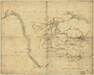
L'Amérique septentrionale divisée en ses principaux états

| Format |
Map |
|---|---|
| Contributors |
Janvier, Jean |
| Dates |
1762 |
| Location |
North America |
| Language |
French |
| Subjects |
North America |
- Title
- L'Amérique septentrionale divisée en ses principaux états
- Description
-
Scale ca. 1:27,000,000.
-
Hand colored.
-
Relief shown pictorially.
-
"No. 32."
-
LC Maps of North America, 1750-1789, 93
-
Differs from other copies in geographic features, place names, historical notes, and coloration in the northern region of Canada, Alaska, and the Pacific Islands.
-
Appears in Atlas moderne, 1771-83, no. 32.
-
Available also through the Library of Congress Web site as a raster image.
-
col. map 32 x 45 cm.
- Creator
- Janvier, Jean.
- Created Published
-
Paris, Chez Lattré, 1762.
- Subject Headings
-
-
North America
-
-
North America.
- Notes
-
-
Scale ca. 1:27,000,000.
-
-
Hand colored.
-
-
Relief shown pictorially.
-
-
"No. 32."
-
-
LC Maps of North America, 1750-1789, 93
-
-
Differs from other copies in geographic features, place names, historical notes, and coloration in the northern region of Canada, Alaska, and the Pacific Islands.
-
-
Appears in Atlas moderne, 1771-83, no. 32.
-
-
Available also through the Library of Congress Web site as a raster image.
- Medium
-
col. map 32 x 45 cm.
- Call Number
-
G3300 1762 .J3
- Repository
-
Library of Congress Geography and Map Division Washington, D.C. 20540-4650 USA dcu
-
Library of Congress Geography and Map Division Washington, D.C. 20540-4650 USA dcu
- Digital Id
-
g3300 ar009300 http://hdl.loc.gov/loc.gmd/g3300.ar009300
- Library of Congress Catalog Number
- 74693991
Rights & Access
The maps in the Map Collections materials were either published prior to 1922, produced by the United States government, or both (see catalogue records that accompany each map for information regarding date of publication and source). The Library of Congress is providing access to these materials for educational and research purposes and is not aware of any U.S. copyright protection (see Title 17 of the United States Code) or any other restrictions in the Map Collection materials.
Note that the written permission of the copyright owners and/or other rights holders (such as publicity and/or privacy rights) is required for distribution, reproduction, or other use of protected items beyond that allowed by fair use or other statutory exemptions. Responsibility for making an independent legal assessment of an item and securing any necessary permissions ultimately rests with persons desiring to use the item.
More about Copyright and other Restrictions
For guidance about compiling full citations consult Citing Primary Sources.
Part of...
More maps like this
-
 L'Amérique septentrionale divisée en ses principaux états
Contributor:
Janvier, Jean
Site:
American Memory-cultural, Main Catalog
Original Format:
Map
Date:
1762
View catalog record
L'Amérique septentrionale divisée en ses principaux états
Contributor:
Janvier, Jean
Site:
American Memory-cultural, Main Catalog
Original Format:
Map
Date:
1762
View catalog record
-

 Carte des anomalies magnétiques de l'Amérique du Nord = Magnetic anomaly map of North America /
Contributor:
North American Magnetic Anomaly Group
Site:
Main Catalog
Original Format:
Map
Date:
2002
Carte des anomalies magnétiques de l'Amérique du Nord = Magnetic anomaly map of North America /
Contributor:
North American Magnetic Anomaly Group
Site:
Main Catalog
Original Format:
Map
Date:
2002
-
 Carta geografica dell' America settentrionale.
Contributor:
L'Isle, Guillaume de
Site:
American Memory-cultural, Main Catalog
Original Format:
Map
Date:
1750
View catalog record
Carta geografica dell' America settentrionale.
Contributor:
L'Isle, Guillaume de
Site:
American Memory-cultural, Main Catalog
Original Format:
Map
Date:
1750
View catalog record
-
 America Septentrionalis a Domino d'Anville in Galliis edita nunc in Anglia. Coloniis in interiorem Virginiam deductis nec non Fluvii Ohio cursu aucta notisque geographicis et ...
Contributor:
Homann Erben (Firm)
Site:
American Memory-cultural, Main Catalog
Original Format:
Map
Date:
1756
View catalog record
America Septentrionalis a Domino d'Anville in Galliis edita nunc in Anglia. Coloniis in interiorem Virginiam deductis nec non Fluvii Ohio cursu aucta notisque geographicis et ...
Contributor:
Homann Erben (Firm)
Site:
American Memory-cultural, Main Catalog
Original Format:
Map
Date:
1756
View catalog record
-
 L'Amérique septentrionale,
Contributor:
Cóvens et Mortier, Cóvens et Mortier
Site:
American Memory-cultural, Main Catalog
Original Format:
Map
Date:
1757
View catalog record
L'Amérique septentrionale,
Contributor:
Cóvens et Mortier, Cóvens et Mortier
Site:
American Memory-cultural, Main Catalog
Original Format:
Map
Date:
1757
View catalog record
-
 A map of the British dominions in North America, according to the Treaty in 1763.
Contributor:
Bell, Peter
Site:
American Memory-cultural, Main Catalog
Original Format:
Map
Date:
1772
View catalog record
A map of the British dominions in North America, according to the Treaty in 1763.
Contributor:
Bell, Peter
Site:
American Memory-cultural, Main Catalog
Original Format:
Map
Date:
1772
View catalog record
-
 Map of the western & middle portions of North America : to illustrate the history of California, Oregon, and the other countries on the north-west ...
Contributor:
Greenhow, Robert
Site:
American Memory-cultural, Main Catalog
Original Format:
Map
View catalog record
Map of the western & middle portions of North America : to illustrate the history of California, Oregon, and the other countries on the north-west ...
Contributor:
Greenhow, Robert
Site:
American Memory-cultural, Main Catalog
Original Format:
Map
View catalog record
-
 Map illustrating the extermination of the American bison /
Contributor:
Hornaday, William T.
Site:
American Memory-cultural, Main Catalog
Original Format:
Map
Date:
1889
View catalog record
Map illustrating the extermination of the American bison /
Contributor:
Hornaday, William T.
Site:
American Memory-cultural, Main Catalog
Original Format:
Map
Date:
1889
View catalog record
-
 [North America from the Mississippi River to the Pacific, between the 35th and 60th parallers of latitude].
Site:
American Memory-cultural, Main Catalog
Original Format:
Map
View catalog record
[North America from the Mississippi River to the Pacific, between the 35th and 60th parallers of latitude].
Site:
American Memory-cultural, Main Catalog
Original Format:
Map
View catalog record
-
 North America.
Contributor:
Jefferys, Thomas
Site:
American Memory-cultural, Main Catalog
Original Format:
Map
Date:
1750
View catalog record
North America.
Contributor:
Jefferys, Thomas
Site:
American Memory-cultural, Main Catalog
Original Format:
Map
Date:
1750
View catalog record
-
 An accurate map of North America. Describing and distinguishing the British, Spanish and French dominions on this great continent; exhibiting the present seat of war, ...
Contributor:
Bowen, Emanuel
Site:
American Memory-cultural, Main Catalog
Original Format:
Map
Date:
1755
View catalog record
An accurate map of North America. Describing and distinguishing the British, Spanish and French dominions on this great continent; exhibiting the present seat of war, ...
Contributor:
Bowen, Emanuel
Site:
American Memory-cultural, Main Catalog
Original Format:
Map
Date:
1755
View catalog record
-
 A map of the British and French settlements in North America.
Contributor:
Lodge, John
Site:
American Memory-cultural, Main Catalog
Original Format:
Map
Date:
1750
View catalog record
A map of the British and French settlements in North America.
Contributor:
Lodge, John
Site:
American Memory-cultural, Main Catalog
Original Format:
Map
Date:
1750
View catalog record
-
 Mapa de una parte de la America Septentrional
Site:
American Memory-cultural, Main Catalog
Original Format:
Map
Date:
1751
View catalog record
Mapa de una parte de la America Septentrional
Site:
American Memory-cultural, Main Catalog
Original Format:
Map
Date:
1751
View catalog record
-
 North America.
Contributor:
Jefferys, Thomas
Site:
American Memory-cultural, Main Catalog
Original Format:
Map
Date:
1755
View catalog record
North America.
Contributor:
Jefferys, Thomas
Site:
American Memory-cultural, Main Catalog
Original Format:
Map
Date:
1755
View catalog record
-
 America Septentrionalis a Domini d'Anville in Galliis edita nunc in Anglia. Coloniis in interiorem Virginiam deductis nec non Fluvii Ohio cursu aucta notisque geographicis et ...
Contributor:
Homann Erben (Firm)
Site:
American Memory-cultural, Main Catalog
Original Format:
Map
Date:
1756
View catalog record
America Septentrionalis a Domini d'Anville in Galliis edita nunc in Anglia. Coloniis in interiorem Virginiam deductis nec non Fluvii Ohio cursu aucta notisque geographicis et ...
Contributor:
Homann Erben (Firm)
Site:
American Memory-cultural, Main Catalog
Original Format:
Map
Date:
1756
View catalog record
-
The North American atlas, selected from the most authentic maps, charts, plans, &c. hitherto published.
Contributor:
Faden, William
Site:
American Memory-cultural, Main Catalog
Original Format:
Map
Date:
1777
View catalog record
You might also like
-
 Monography of the family Unionidæ,
Contributor:
Conrad, T. A.
Site:
Main Catalog
Original Format:
Book
Date:
1836
Monography of the family Unionidæ,
Contributor:
Conrad, T. A.
Site:
Main Catalog
Original Format:
Book
Date:
1836
-
The discovery and exploration of America; a book for American boys and girls,
Contributor:
Gilman, Arthur
Site:
Main Catalog
Original Format:
Book
Date:
1887
-
North American shore birds; a history of the snipes, sandpipers, plovers and their allies, inhabiting the beaches and marshes of the Atlantic and Pacific coasts, ...
Contributor:
Elliot, Daniel Giraud
Site:
Main Catalog
Original Format:
Book
Date:
1895
-
Natural history of western wild animals and guide for hunters, trappers, and sportsmen;
Contributor:
Cartwright, David W.
Site:
Main Catalog
Original Format:
Book
Date:
1875
-
The American salmon fisherman,
Contributor:
Wells, Henry P.
Site:
Main Catalog
Original Format:
Book
Date:
1886
-
A systematic treatise, historical, etiological, and practical, on the principal diseases of the interior valley of North America, as they appear in the Caucasian, African, ...
Contributor:
Drake, Daniel
Site:
Main Catalog
Original Format:
Book
Date:
1854