Map
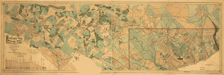
Sanborn Fire Insurance Map from Washington, District of Columbia, District of Columbia.
Views

| Format |
Map |
|---|---|
| Dates |
1916 |
| Location |
Chevy Chase Maryland Takoma Park Washington Washington D.C. |
| Language |
English |
- Title
- Sanborn Fire Insurance Map from Washington, District of Columbia, District of Columbia.
- Description
-
Key map edition. Bound. Includes Chevy Chase, Takoma Park, Maryland. 93 Sheet(s). 1903 - 1916 Vol. 3, 1916.
- Created Published
- Sanborn Map Company, 1903 - 1916 Vol. 3, 1916
- Notes
-
-
Key map edition. Bound.
-
-
Includes Chevy Chase, Takoma Park, Maryland.
-
-
93 Sheet(s).
-
-
1903 - 1916 Vol. 3, 1916.
- Repository
- Library of Congress Geography and Map Division Washington, D.C. 20540-4650 USA
- Digital Id
-
http://www.loc.gov/item/sanborn01227_004
-
http://hdl.loc.gov/loc.gmd/g3851gm.g01227004
Rights & Access
The maps in the Map Collections materials were either published prior to 1922, produced by the United States government, or both (see catalogue records that accompany each map for information regarding date of publication and source). The Library of Congress is providing access to these materials for educational and research purposes and is not aware of any U.S. copyright protection (see Title 17 of the United States Code) or any other restrictions in the Map Collection materials.
Note that the written permission of the copyright owners and/or other rights holders (such as publicity and/or privacy rights) is required for distribution, reproduction, or other use of protected items beyond that allowed by fair use or other statutory exemptions. Responsibility for making an independent legal assessment of an item and securing any necessary permissions ultimately rests with persons desiring to use the item.
More about Copyright and other Restrictions
For guidance about compiling full citations consult Citing Primary Sources.
Part of...
-
Sanborn Maps
[50014]
-
Geography And Maps Division
[60803]
-
American Memory
[1120694]
More maps like this
-
 Plan of the Rebel attack on Washington, D.C., July 11th and 12th, 1864.
Contributor:
Sneden, Robert Knox
Site:
American Memory-cultural
Original Format:
Map
Date:
1864
Plan of the Rebel attack on Washington, D.C., July 11th and 12th, 1864.
Contributor:
Sneden, Robert Knox
Site:
American Memory-cultural
Original Format:
Map
Date:
1864
-
 Sketch of the march of the British Army under Gen'l Ross from the 19th to the 29th August 1814 : [central Maryland between Benedict and ...
Contributor:
Evans, D.
Site:
American Memory-cultural, Main Catalog
Original Format:
Map
Date:
1814
View catalog record
Sketch of the march of the British Army under Gen'l Ross from the 19th to the 29th August 1814 : [central Maryland between Benedict and ...
Contributor:
Evans, D.
Site:
American Memory-cultural, Main Catalog
Original Format:
Map
Date:
1814
View catalog record
-
 Part of map of portions of the milit'y dep'ts of Washington, Pennsylvania, Annapolis, and north eastern Virginia /
Contributor:
United States. Topographical Bureau
Site:
American Memory-cultural, Main Catalog
Original Format:
Map
Date:
1861
View catalog record
Part of map of portions of the milit'y dep'ts of Washington, Pennsylvania, Annapolis, and north eastern Virginia /
Contributor:
United States. Topographical Bureau
Site:
American Memory-cultural, Main Catalog
Original Format:
Map
Date:
1861
View catalog record
-
 Reconnaissance of "Anacostia" above Wash. Navy Yd. /
Contributor:
Cluss, A.
Site:
American Memory-cultural, Main Catalog
Original Format:
Map
Date:
1861
View catalog record
Reconnaissance of "Anacostia" above Wash. Navy Yd. /
Contributor:
Cluss, A.
Site:
American Memory-cultural, Main Catalog
Original Format:
Map
Date:
1861
View catalog record
-
 [Map of northern Virginia and part of Maryland].
Site:
American Memory-cultural, Main Catalog
Original Format:
Map
Date:
1862
View catalog record
[Map of northern Virginia and part of Maryland].
Site:
American Memory-cultural, Main Catalog
Original Format:
Map
Date:
1862
View catalog record
-
 Topographical sketch of the environs of Washington, D.C. : (survey of locality for public park & site for a presidential mansion) /
Contributor:
Michler, N.
Site:
American Memory-cultural, Main Catalog
Original Format:
Map
Date:
1901
View catalog record
Topographical sketch of the environs of Washington, D.C. : (survey of locality for public park & site for a presidential mansion) /
Contributor:
Michler, N.
Site:
American Memory-cultural, Main Catalog
Original Format:
Map
Date:
1901
View catalog record
-
 Map of the located route of the Metropolitan Rail Road and the adjacent country comprising the District of Columbia and the counties of Montgomery, Frederick, ...
Contributor:
Hutton, Wm. R.
Site:
American Memory-cultural, Main Catalog
Original Format:
Map
Date:
1855-04-30
View catalog record
Map of the located route of the Metropolitan Rail Road and the adjacent country comprising the District of Columbia and the counties of Montgomery, Frederick, ...
Contributor:
Hutton, Wm. R.
Site:
American Memory-cultural, Main Catalog
Original Format:
Map
Date:
1855-04-30
View catalog record
-
 Map of Anacostia River in the District of Columbia and Maryland /
Contributor:
Hains, Peter C.
Site:
American Memory-cultural, Main Catalog
Original Format:
Map
Date:
1891
View catalog record
Map of Anacostia River in the District of Columbia and Maryland /
Contributor:
Hains, Peter C.
Site:
American Memory-cultural, Main Catalog
Original Format:
Map
Date:
1891
View catalog record
-
 Map of the state of Virginia /
Contributor:
Nicholson, W. L.
Site:
American Memory-cultural
Original Format:
Map
Date:
1863
Map of the state of Virginia /
Contributor:
Nicholson, W. L.
Site:
American Memory-cultural
Original Format:
Map
Date:
1863
-
 Real estate map of the Metropolitan Branch of the Baltimore and Ohio Railroad Company between Washington, D.C., and Rockville, Md., and adjacent land holdings : ...
Contributor:
Fava Naeff & Co
Site:
American Memory-cultural, Main Catalog
Original Format:
Map
Date:
1890
View catalog record
Real estate map of the Metropolitan Branch of the Baltimore and Ohio Railroad Company between Washington, D.C., and Rockville, Md., and adjacent land holdings : ...
Contributor:
Fava Naeff & Co
Site:
American Memory-cultural, Main Catalog
Original Format:
Map
Date:
1890
View catalog record
-
 Sanborn Fire Insurance Map from Washington, District of Columbia, District of Columbia.
Site:
American Memory-cultural
Original Format:
Map
Date:
1903
Sanborn Fire Insurance Map from Washington, District of Columbia, District of Columbia.
Site:
American Memory-cultural
Original Format:
Map
Date:
1903
-
 Sanborn Fire Insurance Map from Washington, District of Columbia, District of Columbia.
Site:
American Memory-cultural
Original Format:
Map
Date:
1888
Sanborn Fire Insurance Map from Washington, District of Columbia, District of Columbia.
Site:
American Memory-cultural
Original Format:
Map
Date:
1888
-
 Sanborn Fire Insurance Map from Washington, District of Columbia, District of Columbia.
Site:
American Memory-cultural
Original Format:
Map
Date:
1916
Sanborn Fire Insurance Map from Washington, District of Columbia, District of Columbia.
Site:
American Memory-cultural
Original Format:
Map
Date:
1916
-
 Martenet and Bond's map of Montgomery County, Maryland /
Contributor:
Martenet, Simon J.
Site:
American Memory-cultural, Main Catalog
Original Format:
Map
Date:
1865
View catalog record
Martenet and Bond's map of Montgomery County, Maryland /
Contributor:
Martenet, Simon J.
Site:
American Memory-cultural, Main Catalog
Original Format:
Map
Date:
1865
View catalog record
-
 Topographical map of Washington, D.C., and vicinity. Showing the Union forts and defences built 1861-3.
Contributor:
Sneden, Robert Knox
Site:
American Memory-cultural
Original Format:
Map
Date:
1861
Topographical map of Washington, D.C., and vicinity. Showing the Union forts and defences built 1861-3.
Contributor:
Sneden, Robert Knox
Site:
American Memory-cultural
Original Format:
Map
Date:
1861
-
 Within sight of the White House : section of Washington, D.C., known as "Hooker's Division," which contains 50 saloons and 109 bawdy-houses--list of 61 places ...
Site:
American Memory-cultural, Main Catalog
Original Format:
Map
Date:
1890
View catalog record
Within sight of the White House : section of Washington, D.C., known as "Hooker's Division," which contains 50 saloons and 109 bawdy-houses--list of 61 places ...
Site:
American Memory-cultural, Main Catalog
Original Format:
Map
Date:
1890
View catalog record
You might also like
-
 Myrtle Olive Smiley VHP Collection
Contributor:
Smiley, Myrtle Olive
Site:
Veterans History Project
Original Format:
Personal Narrative
Date:
2008-01-01
Myrtle Olive Smiley VHP Collection
Contributor:
Smiley, Myrtle Olive
Site:
Veterans History Project
Original Format:
Personal Narrative
Date:
2008-01-01
-

 Washington, D.C. June-July, 1942. Tourist homes and boarding houses in Washington and just across the District line in Maryland
Contributor:
Collins, Marjory
Site:
Main Catalog
Original Format:
Photo, Print, Drawing
Date:
1942
Washington, D.C. June-July, 1942. Tourist homes and boarding houses in Washington and just across the District line in Maryland
Contributor:
Collins, Marjory
Site:
Main Catalog
Original Format:
Photo, Print, Drawing
Date:
1942
-
 Washington, D.C. June-July, 1942. Tourist homes and boarding houses in Washington and just across the District line in Maryland
Contributor:
Collins, Marjory, United States. Farm Security Administration
Site:
Prints & Photographs
Original Format:
Photo, Print, Drawing
Date:
1942
Washington, D.C. June-July, 1942. Tourist homes and boarding houses in Washington and just across the District line in Maryland
Contributor:
Collins, Marjory, United States. Farm Security Administration
Site:
Prints & Photographs
Original Format:
Photo, Print, Drawing
Date:
1942
-
 Fourth of July parade at Takoma Park
Site:
Prints & Photographs, Main Catalog
Original Format:
Photo, Print, Drawing
Date:
1923
View catalog record
Fourth of July parade at Takoma Park
Site:
Prints & Photographs, Main Catalog
Original Format:
Photo, Print, Drawing
Date:
1923
View catalog record
-
 [Dome gas service station, Takoma Park, Md.]
Site:
Prints & Photographs, Main Catalog
Original Format:
Photo, Print, Drawing
Date:
1921
View catalog record
[Dome gas service station, Takoma Park, Md.]
Site:
Prints & Photographs, Main Catalog
Original Format:
Photo, Print, Drawing
Date:
1921
View catalog record
-
[Dome gas service station, Takoma Park, Md.]
Site:
American Memory-cultural, Main Catalog
Original Format:
Photo, Print, Drawing
Date:
1921
View catalog record