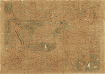
Map
Amérique septentrion.lle [i.e. septentrionale] : composée, corigée, et augmētée, sur les iournaux, mémoires, et observations les plus justes qui en ón'́etes.tes en l'année 1685 & 1686, par plusieurs particuliés /

| Format |
Map |
|---|---|
| Contributors |
Franquelin, Jean Baptiste Louis |
| Dates |
1685 |
| Location |
Canada North America United States |
| Language |
French |
| Subjects |
Canada East East (U.S.) North America United States |
- Title
- Amérique septentrion.lle [i.e. septentrionale] : composée, corigée, et augmētée, sur les iournaux, mémoires, et observations les plus justes qui en ón'́etes.tes en l'année 1685 & 1686, par plusieurs particuliés /
- Description
-
Covers Canada, Hudson Bay region, and eastern United States.
-
Shows lakes, rivers, villages, and other geographical entities.
-
Pen-and-ink and watercolor.
-
"A Monseigneu, Monseigneur le Marquis de Seignelay, et de Lonré, baron de Seaux, conseiller du Roy en tous conseils, secretaire d'estat & des commandemens de Sa Majesté, commandeur et grand thresorier de ses ordres. Par son très-humble très-obéissant & très obligé serviteur I-Baptiste Louis Franquelin maistre d'idrographie pour le Roy à Quebec."
-
"Bibliothèque du Dépôt des cartes et plans de La Marine, Atlas B4040 - piece n. 6."
-
Available also through the Library of Congress Web site as a raster image.
-
Copy annotated in brown pencil on lower left and right corners: No. 3--124885.
-
Copy imperfect: Brittle and small parts of map missing.
-
1 ms. map on 2 sheets : col., mounted on cloth backing ; 93 x 95 cm., sheets 96 x 54 cm. and 96 x 53 cm.
-
"A Monseigneu, Monseigneur le Marquis de Seignelay, et de Lonré, baron de Seaux, conseiller du Roy en tous conseils, secretaire d'estat & des commandemens de Sa Majesté, commandeur et grand thresorier de ses ordres. Par son très-humble très-obéissant & très obligé serviteur I-Baptiste Louis Franquelin maistre d'idrographie pour le Roy à Quebec."
-
"Bibliothèque du Dépôt des cartes et plans de La Marine, Atlas B4040 - piece n. 6."
- Creator
- Franquelin, Jean Baptiste Louis.
- Created Published
-
[1685]
- Subject Headings
-
-
North America
-
-
Canada
-
-
East (U.S.)
-
-
North America.
-
-
Canada.
-
-
United States--East.
- Notes
-
-
Covers Canada, Hudson Bay region, and eastern United States.
-
-
Shows lakes, rivers, villages, and other geographical entities.
-
-
Pen-and-ink and watercolor.
-
-
"A Monseigneu, Monseigneur le Marquis de Seignelay, et de Lonré, baron de Seaux, conseiller du Roy en tous conseils, secretaire d'estat & des commandemens de Sa Majesté, commandeur et grand thresorier de ses ordres. Par son très-humble très-obéissant & très obligé serviteur I-Baptiste Louis Franquelin maistre d'idrographie pour le Roy à Quebec."
-
-
"Bibliothèque du Dépôt des cartes et plans de La Marine, Atlas B4040 - piece n. 6."
-
-
Available also through the Library of Congress Web site as a raster image.
-
-
Copy annotated in brown pencil on lower left and right corners: No. 3--124885.
-
-
Copy imperfect: Brittle and small parts of map missing.
- Medium
-
1 ms. map on 2 sheets : col., mounted on cloth backing ; 93 x 95 cm., sheets 96 x 54 cm. and 96 x 53 cm.
- Call Number
-
G3300 1685 .F7
- Repository
-
Library of Congress Geography and Map Division Washington, D.C. 20540-4650 USA dcu
- Digital Id
-
g3300 ct000667 http://hdl.loc.gov/loc.gmd/g3300.ct000667
- Library of Congress Catalog Number
- 2002622263
Rights & Access
The maps in the Map Collections materials were either published prior to 1922, produced by the United States government, or both (see catalogue records that accompany each map for information regarding date of publication and source). The Library of Congress is providing access to these materials for educational and research purposes and is not aware of any U.S. copyright protection (see Title 17 of the United States Code) or any other restrictions in the Map Collection materials.
Note that the written permission of the copyright owners and/or other rights holders (such as publicity and/or privacy rights) is required for distribution, reproduction, or other use of protected items beyond that allowed by fair use or other statutory exemptions. Responsibility for making an independent legal assessment of an item and securing any necessary permissions ultimately rests with persons desiring to use the item.
More about Copyright and other Restrictions
For guidance about compiling full citations consult Citing Primary Sources.
Part of...
-
Louisiana: European Explorations And The Louisiana Purchase
[77]
-
Discovery And Exploration
[150]
-
Geography And Maps Division
[60803]
-
American Memory
[1120703]
More maps like this
-
 Carte de l'Amerique Septentrionnale : depuis le 25, jusqu'au 65p0s deg. de latt. & environ 140, & 235 deg. de longitude / par Iean Baptiste ...
Contributor:
Franquelin, Jean Baptiste Louis
Site:
American Memory-cultural, Main Catalog
Original Format:
Map
Date:
1909
View catalog record
Carte de l'Amerique Septentrionnale : depuis le 25, jusqu'au 65p0s deg. de latt. & environ 140, & 235 deg. de longitude / par Iean Baptiste ...
Contributor:
Franquelin, Jean Baptiste Louis
Site:
American Memory-cultural, Main Catalog
Original Format:
Map
Date:
1909
View catalog record
-
 Franquelin's map of Louisiana.
Contributor:
Franquelin, Jean Baptiste Louis
Site:
American Memory-cultural, Main Catalog
Original Format:
Map
Date:
1896
View catalog record
Franquelin's map of Louisiana.
Contributor:
Franquelin, Jean Baptiste Louis
Site:
American Memory-cultural, Main Catalog
Original Format:
Map
Date:
1896
View catalog record
-
 The Mississippi /
Contributor:
Franquelin, Jean Baptiste Louis
Site:
American Memory-cultural, Main Catalog
Original Format:
Map
Date:
1682
View catalog record
The Mississippi /
Contributor:
Franquelin, Jean Baptiste Louis
Site:
American Memory-cultural, Main Catalog
Original Format:
Map
Date:
1682
View catalog record
-
 [Etats-Unie: Partie septentrionale].
Site:
American Memory-cultural, Main Catalog
Original Format:
Map
Date:
1708
View catalog record
[Etats-Unie: Partie septentrionale].
Site:
American Memory-cultural, Main Catalog
Original Format:
Map
Date:
1708
View catalog record
-
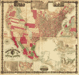
 Harper's cereographic map of the United States and Canada : showing the canals, rail roads, and principal stage routes /
Contributor:
Breese, Samuel
Site:
American Memory-cultural, Main Catalog
Original Format:
Map
Date:
1847
View catalog record
Harper's cereographic map of the United States and Canada : showing the canals, rail roads, and principal stage routes /
Contributor:
Breese, Samuel
Site:
American Memory-cultural, Main Catalog
Original Format:
Map
Date:
1847
View catalog record
-
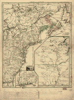
 Carte des possessions françoises et angloises dans le Canada, et partie de la Louisiane, 1756.
Contributor:
Longchamps
Site:
American Memory-cultural, Main Catalog
Original Format:
Map
Date:
1769
View catalog record
Carte des possessions françoises et angloises dans le Canada, et partie de la Louisiane, 1756.
Contributor:
Longchamps
Site:
American Memory-cultural, Main Catalog
Original Format:
Map
Date:
1769
View catalog record
-
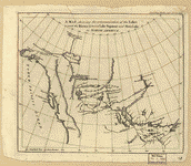 A map shewing the communication of the lakes and the rivers between Lake Superior and Slave Lake in North America.
Contributor:
Pond, Peter
Site:
American Memory-cultural, Main Catalog
Original Format:
Map
Date:
1790
View catalog record
A map shewing the communication of the lakes and the rivers between Lake Superior and Slave Lake in North America.
Contributor:
Pond, Peter
Site:
American Memory-cultural, Main Catalog
Original Format:
Map
Date:
1790
View catalog record
-
 Canada et Louisiane
Contributor:
Le Rouge, Georges-Louis
Site:
American Memory-cultural, Main Catalog
Original Format:
Map
Date:
1755
View catalog record
Canada et Louisiane
Contributor:
Le Rouge, Georges-Louis
Site:
American Memory-cultural, Main Catalog
Original Format:
Map
Date:
1755
View catalog record
-
 Canada et Louisiane,
Contributor:
Le Rouge, Georges-Louis
Site:
American Memory-cultural, Main Catalog
Original Format:
Map
Date:
1755
View catalog record
Canada et Louisiane,
Contributor:
Le Rouge, Georges-Louis
Site:
American Memory-cultural, Main Catalog
Original Format:
Map
Date:
1755
View catalog record
-
 Carte du Canada et de la Louisiane qui forment la Nouvelle France et des colonies angloises ou sont representez les pays contestez.
Contributor:
Nolin, Jean Baptiste
Site:
American Memory-cultural, Main Catalog
Original Format:
Map
Date:
1756
View catalog record
Carte du Canada et de la Louisiane qui forment la Nouvelle France et des colonies angloises ou sont representez les pays contestez.
Contributor:
Nolin, Jean Baptiste
Site:
American Memory-cultural, Main Catalog
Original Format:
Map
Date:
1756
View catalog record
-
 Partie occidentale de la Nouvelle France ou Canada.
Contributor:
Bellin, Jacques Nicolas
Site:
American Memory-cultural, Main Catalog
Original Format:
Map
Date:
1755
View catalog record
Partie occidentale de la Nouvelle France ou Canada.
Contributor:
Bellin, Jacques Nicolas
Site:
American Memory-cultural, Main Catalog
Original Format:
Map
Date:
1755
View catalog record
-
 Partie occidentale de la Nouvelle France ou du Canada
Contributor:
Bellin, Jacques Nicolas
Site:
American Memory-cultural, Main Catalog
Original Format:
Map
Date:
1755
View catalog record
Partie occidentale de la Nouvelle France ou du Canada
Contributor:
Bellin, Jacques Nicolas
Site:
American Memory-cultural, Main Catalog
Original Format:
Map
Date:
1755
View catalog record
-
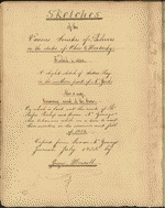 Sketches of the various Societies of Belivers [i.e. Believers] in the states of Ohio & Kentucky. To which is added a slight sketch of Sodus ...
Contributor:
Youngs, Isaac N.
Site:
American Memory-cultural, Main Catalog
Original Format:
Map
Date:
1835
View catalog record
Sketches of the various Societies of Belivers [i.e. Believers] in the states of Ohio & Kentucky. To which is added a slight sketch of Sodus ...
Contributor:
Youngs, Isaac N.
Site:
American Memory-cultural, Main Catalog
Original Format:
Map
Date:
1835
View catalog record
-
 The Washington map of the United States /
Contributor:
Maury, Matthew Fontaine
Site:
American Memory-cultural, Main Catalog
Original Format:
Map
Date:
1860
View catalog record
The Washington map of the United States /
Contributor:
Maury, Matthew Fontaine
Site:
American Memory-cultural, Main Catalog
Original Format:
Map
Date:
1860
View catalog record
-
 Karte des oestlichē oder ehemahligē englischen Amerika nach den Besitzungen und Grænzen nach dem Frieden von 1783.
Contributor:
Moser, Johann Jakob
Site:
American Memory-cultural, Main Catalog
Original Format:
Map
Date:
1784
View catalog record
Karte des oestlichē oder ehemahligē englischen Amerika nach den Besitzungen und Grænzen nach dem Frieden von 1783.
Contributor:
Moser, Johann Jakob
Site:
American Memory-cultural, Main Catalog
Original Format:
Map
Date:
1784
View catalog record
-
 Morse's North American atlas.
Contributor:
Morse, Sidney E.
Site:
American Memory-cultural, Main Catalog
Original Format:
Map
Date:
1842
View catalog record
Morse's North American atlas.
Contributor:
Morse, Sidney E.
Site:
American Memory-cultural, Main Catalog
Original Format:
Map
Date:
1842
View catalog record
You might also like
-

 NAFTA's and CUSFTA's impact on international trade
Contributor:
Romalis, John
Site:
Main Catalog
Original Format:
Book
Date:
2005
NAFTA's and CUSFTA's impact on international trade
Contributor:
Romalis, John
Site:
Main Catalog
Original Format:
Book
Date:
2005
-
U.S.-Canada relations : hearing before the Subcommittee on the Western Hemisphere of the Committee on International Relations, House of Representatives, One Hundred Ninth Congress, second ...
Contributor:
United States. Congress. House. Committee on International Relations. Subcommittee on the Western Hemisphere
Site:
Main Catalog
Original Format:
Book
Date:
2006-05-25
-
NAFTA at year twelve : hearing before the Subcommittee on International Trade of the Committee on Finance, United States Senate, One Hundred Ninth Congress, second ...
Contributor:
United States. Congress. Senate. Committee on Finance. Subcommittee on International Trade
Site:
Main Catalog
Original Format:
Book
Date:
2006-09-11
-
NAFTA : a ten year perspective and implications for the future : hearing before the Subcommittee on International Economic Policy, Export and Trade Promotion of ...
Contributor:
United States. Congress. Senate. Committee on Foreign Relations. Subcommittee on International Economic Policy, Export and Trade Promotion
Site:
Main Catalog
Original Format:
Book
Date:
2004-04-20
-
Communication from the secretary of the Treasury transmitting ...
Contributor:
United States. Dept. of the Treasury
Site:
Main Catalog
Original Format:
Book
Date:
1854
-
Keeping the borders open : conclusions and recommendations /
Contributor:
Agricultural and Food Policy Systems Information Workshop
Site:
Main Catalog
Original Format:
Book
Date:
2002