Map
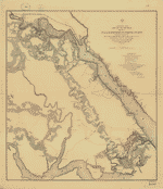
Index sheet of battlefield maps for Fredericksburg, Spottsylvania C. H., Wilderness, Chancellorsville, Virginia. [1862-64] To accompany report of the Battlefield Commission created by Act of Congress public no. 261, 68th Congress dated 1925. 26 x 34 cm.

| Format |
Map |
|---|---|
| Dates |
1925 |
| Location |
United States Virginia |
| Language |
English |
| Subjects |
Campaigns Civil War History United States Virginia |
- Title
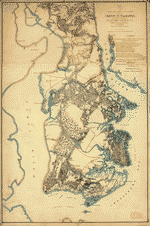
- Index sheet of battlefield maps for Fredericksburg, Spottsylvania C. H., Wilderness, Chancellorsville, Virginia. [1862-64] To accompany report of the Battlefield Commission created by Act of Congress public no. 261, 68th Congress dated 1925. 26 x 34 cm.
- Description
-
Scale ca. 1:135,000.
-
LC Civil War Maps (2nd ed.), 488.2
-
Map indicates troop positions, trenches, public roads, "roads, special, to be built," "property to be acquired," and "some of the important points to be marked."
-
Inset: Locality sketch. 9 x 7 cm.
-
Another issue with the imprint "Engineer Reproduction Plant, U.S. Army, Washington Barracks, D.C., 1926" accompanies the report "To establish a national military park at and near Fredericksburg, Va.," 1926. (69th Cong., 1st sess., Report no. 814). 3 p.
-
Description derived from published bibliography.
-
Available also through the Library of Congress web site as raster image.
-
1 index, col., 26 x 34 cm.
- Created Published
-
[S.l., 1925]
- Subject Headings
-
-
Virginia--History--Civil War, 1861-1865--Campaigns
-
-
United States--Virginia.
- Notes
-
-
Scale ca. 1:135,000.
-
-
LC Civil War Maps (2nd ed.), 488.2
-
-
Map indicates troop positions, trenches, public roads, "roads, special, to be built," "property to be acquired," and "some of the important points to be marked."
-
-
Inset: Locality sketch. 9 x 7 cm.
-
-
Another issue with the imprint "Engineer Reproduction Plant, U.S. Army, Washington Barracks, D.C., 1926" accompanies the report "To establish a national military park at and near Fredericksburg, Va.," 1926. (69th Cong., 1st sess., Report no. 814). 3 p.
-
-
Description derived from published bibliography.
-
-
Available also through the Library of Congress web site as raster image.
- Medium
-
1 index, col., 26 x 34 cm.
- Call Number
-
G3881.S5 1925 .I5
- Repository
-
Library of Congress Geography and Map Division Washington, D.C. 20540-4650 dcu
- Digital Id
-
g3881s cw0488200 http://hdl.loc.gov/loc.gmd/g3881s.cw0488200
- Library of Congress Catalog Number
- 99448880
Rights & Access
The maps in the Map Collections materials were either published prior to 1922, produced by the United States government, or both (see catalogue records that accompany each map for information regarding date of publication and source). The Library of Congress is providing access to these materials for educational and research purposes and is not aware of any U.S. copyright protection (see Title 17 of the United States Code) or any other restrictions in the Map Collection materials.
Note that the written permission of the copyright owners and/or other rights holders (such as publicity and/or privacy rights) is required for distribution, reproduction, or other use of protected items beyond that allowed by fair use or other statutory exemptions. Responsibility for making an independent legal assessment of an item and securing any necessary permissions ultimately rests with persons desiring to use the item.
More about Copyright and other Restrictions
For guidance about compiling full citations consult Citing Primary Sources.
Part of...
-
Civil War Maps
[2281]
-
Military Battles And Campaigns Cartographic Items
[3867]
-
Geography And Maps Division
[60803]
-
American Memory
[1120703]
More maps like this
-
 Central [Virginia] showing Maj. Gen'l P. H. Sherida[n's campaigns] and marches of the cavalry under his [command] in 1864-65
Contributor:
Von Reizenstein, B.
Site:
American Memory-cultural, Main Catalog
Original Format:
Map
Date:
1865
View catalog record
Central [Virginia] showing Maj. Gen'l P. H. Sherida[n's campaigns] and marches of the cavalry under his [command] in 1864-65
Contributor:
Von Reizenstein, B.
Site:
American Memory-cultural, Main Catalog
Original Format:
Map
Date:
1865
View catalog record
-
 Military maps illustrating the operations of the armies of the Potomac and James against Richmond, May 4th, 1864 to April 9th, 1865 : including battlefields ...
Contributor:
United States. War Dept. Corps of Engineers
Site:
American Memory-cultural, Main Catalog
Original Format:
Map
Date:
1867
View catalog record
Military maps illustrating the operations of the armies of the Potomac and James against Richmond, May 4th, 1864 to April 9th, 1865 : including battlefields ...
Contributor:
United States. War Dept. Corps of Engineers
Site:
American Memory-cultural, Main Catalog
Original Format:
Map
Date:
1867
View catalog record
-
 White House to Harrisons Landing
Contributor:
Abbot, Henry L.
Site:
American Memory-cultural, Main Catalog
Original Format:
Map
Date:
1862
View catalog record
White House to Harrisons Landing
Contributor:
Abbot, Henry L.
Site:
American Memory-cultural, Main Catalog
Original Format:
Map
Date:
1862
View catalog record
-
 Williamsburg to White House
Contributor:
Abbot, Henry L.
Site:
American Memory-cultural, Main Catalog
Original Format:
Map
Date:
1862
View catalog record
Williamsburg to White House
Contributor:
Abbot, Henry L.
Site:
American Memory-cultural, Main Catalog
Original Format:
Map
Date:
1862
View catalog record
-
 White House to Harrisons Landing /
Contributor:
Abbot, Henry L.
Site:
American Memory-cultural, Main Catalog
Original Format:
Map
Date:
1862
View catalog record
White House to Harrisons Landing /
Contributor:
Abbot, Henry L.
Site:
American Memory-cultural, Main Catalog
Original Format:
Map
Date:
1862
View catalog record
-
 [Map of the siege of Suffolk, Va., 1863.]
Contributor:
Allen, Orrin Sweet
Site:
American Memory-cultural
Original Format:
Map
Date:
1863
[Map of the siege of Suffolk, Va., 1863.]
Contributor:
Allen, Orrin Sweet
Site:
American Memory-cultural
Original Format:
Map
Date:
1863
-
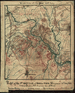 Plan of the 1st Battle of Bull Run Virginia 21st July 1861. Topography from U.S. Engineers official map.
Contributor:
Sneden, Robert Knox
Site:
American Memory-cultural
Original Format:
Map
Date:
1861
Plan of the 1st Battle of Bull Run Virginia 21st July 1861. Topography from U.S. Engineers official map.
Contributor:
Sneden, Robert Knox
Site:
American Memory-cultural
Original Format:
Map
Date:
1861
-
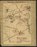
 Map of part of battlefield of Bull Run July 1861 : showing positions of each army at opening of battle.
Contributor:
Sneden, Robert Knox
Site:
American Memory-cultural
Original Format:
Map
Date:
1861
Map of part of battlefield of Bull Run July 1861 : showing positions of each army at opening of battle.
Contributor:
Sneden, Robert Knox
Site:
American Memory-cultural
Original Format:
Map
Date:
1861
-
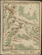 Plan of the Battle of Dranesville Va Decr 20th 1861.
Contributor:
Sneden, Robert Knox
Site:
American Memory-cultural
Original Format:
Map
Date:
1861
Plan of the Battle of Dranesville Va Decr 20th 1861.
Contributor:
Sneden, Robert Knox
Site:
American Memory-cultural
Original Format:
Map
Date:
1861
-
 Skeleton map of battlefield of Bull Run Virginia : showing 1st battle at Blackburn's Ford.
Contributor:
Sneden, Robert Knox
Site:
American Memory-cultural
Original Format:
Map
Date:
1861
Skeleton map of battlefield of Bull Run Virginia : showing 1st battle at Blackburn's Ford.
Contributor:
Sneden, Robert Knox
Site:
American Memory-cultural
Original Format:
Map
Date:
1861
-
 [Yorktown to Williamsburg]
Contributor:
Abbot, Henry L.
Site:
American Memory-cultural, Main Catalog
Original Format:
Map
Date:
1862
View catalog record
[Yorktown to Williamsburg]
Contributor:
Abbot, Henry L.
Site:
American Memory-cultural, Main Catalog
Original Format:
Map
Date:
1862
View catalog record
-
 Richmond, Petersburg, and vicinity Genl. Grant's campaign war map /
Contributor:
Baumgarten, J.
Site:
American Memory-cultural
Original Format:
Map
Date:
1864
Richmond, Petersburg, and vicinity Genl. Grant's campaign war map /
Contributor:
Baumgarten, J.
Site:
American Memory-cultural
Original Format:
Map
Date:
1864
-
 [White House to Harrisons Landing].
Contributor:
Abbot, Henry L.
Site:
American Memory-cultural
Original Format:
Map
[White House to Harrisons Landing].
Contributor:
Abbot, Henry L.
Site:
American Memory-cultural
Original Format:
Map
-
 Yorktown to Williamsburg
Contributor:
Abbot, Henry L.
Site:
American Memory-cultural, Main Catalog
Original Format:
Map
Date:
1862
View catalog record
Yorktown to Williamsburg
Contributor:
Abbot, Henry L.
Site:
American Memory-cultural, Main Catalog
Original Format:
Map
Date:
1862
View catalog record
-
 [Central Virginia showing Lieut. Gen'l. U.S. Grant's Campaign and marches of the armies under his command in 1864-65
Contributor:
United States. Army. Corps of Engineers
Site:
American Memory-cultural, Main Catalog
Original Format:
Map
Date:
1865
View catalog record
[Central Virginia showing Lieut. Gen'l. U.S. Grant's Campaign and marches of the armies under his command in 1864-65
Contributor:
United States. Army. Corps of Engineers
Site:
American Memory-cultural, Main Catalog
Original Format:
Map
Date:
1865
View catalog record
You might also like
-

 During the war and after the war.
Contributor:
[Scott, John]
Site:
Main Catalog
Original Format:
Book
Date:
1896
During the war and after the war.
Contributor:
[Scott, John]
Site:
Main Catalog
Original Format:
Book
Date:
1896
-
The Shenandoah Valley and Virginia, 1861 to 1865;
Contributor:
Kellogg, Sanford C.
Site:
Main Catalog
Original Format:
Book
Date:
1903
-
Report of the operations of Maj.-Gen. Frémont, while in command of the Mountain Department, during the spring and summer of 1862.
Contributor:
Frémont, John Charles
Site:
Main Catalog
Original Format:
Book
Date:
1866
-
Military review of the campaign in Virginia & Maryland under Generals John C. Fremont, N.P. Banks, Irwin McDowell, Franz Sigel, John Pope, James S. Wadsworth, ...
Contributor:
Petersen, Frederick A.
Site:
Main Catalog
Original Format:
Book
Date:
1862
-
History of the campaign of Gen. T.J. (Stonewall) Jackson in the Shenandoah Valley of Virginia : From November 4, 1861, to June 17, 1862 /
Contributor:
Allan, William
Site:
Main Catalog
Original Format:
Book
Date:
1861-11-04
-
Sheridan's veterans ...
Contributor:
[Buffum, Francis Henry]
Site:
Main Catalog
Original Format:
Book
Date:
1883