

- Also On
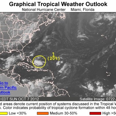
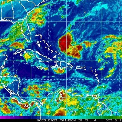
- A large area of showers and thunderstorms associated with a tropical wave continues this afternoon over the central Caribbean Sea. There remains a high chance of it becoming a tropical cyclone during the next 48 hours as it moves slowly tow...ard the west before stalling well south of Jamaica. Heavy rains are likely to spread over Jamaica, eastern Cuba and Hispaniola during the next few days, possibly triggering life-threatening flash floods and mud slides, especially in areas of high terrain.See More
Get the latest on the tropics anytime by visiting the NOAA NHC website at www.hurricanes.gov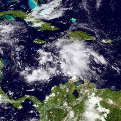
- Showers and thunderstorms have been increasing during the past several hours near a tropical wave and associated area of low pressure located over the central Caribbean Sea. There remains a high chance of it becoming a tropical cyclone duri...ng the next 48See More
hours as it moves slowly toward the west. Heavy rains are likely to spread over Jamaica, eastern Cuba and Hispaniola during the next few days, possibly triggering life-threatening flash floods and mud slides, especially in areas of high terrain.
Elsewhere, an upper-low interacting with a tropical wave is centered about 850 miles east-northeast of the Leeward Islands. It has a medium chance of becoming a tropical cyclone during the next 48 hours as it moves toward the west-northwest.
Get the latest on the tropics anytime by visiting the NOAA NHC website at www.hurricanes.gov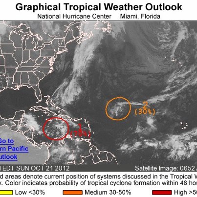
- There has been no change in organization tonight with the showers and thunderstorms associated with the tropical wave over the central Caribbean Sea. However, there remains a high chance of it becoming a tropical cyclone during the next 48 ...hours as it moves slowly toward the west. Heavy rains are likely to spread over Jamaica, eastern Cuba and Hispaniola during the next few days, possibly triggering life-threatening flash floods and mud slides, especially in areas of high terrain.See More
Elsewhere, an upper-low interacting with a tropical wave is centered about 1000 miles east-northeast of the Leeward Islands. It has a medium chance of becoming a tropical cyclone during the next 48 hours as it moves toward the west-northwest.
Get the latest on the tropics anytime by visiting the NOAA NHC website at www.hurricanes.gov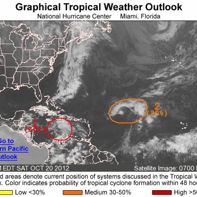
- Satellite images this afternoon indicate that the showers and thunderstorms associated with a tropical wave over the central Caribbean Sea have become better organized. This system now has a high chance of becoming a tropical cyclone during the next 48 hours as it moves slowly toward the west.
Get the latest on the tropics anytime by visiting the NOAA NHC website at www.hurricanes.gov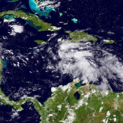
- NHC continues to monitor two areas of disturbed weather this morning over the Atlantic basin.
One is a tropical wave producing a large but disorganized area of clouds and thunderstorms between Hispaniola and northern South America. Environm...ental conditions are forecast to become more favorable for development, and the system has a medium chance of becoming a tropical cyclone during the next 48 hours as it moves west over the central and western Caribbean Sea.See More
The other is a concentrated area of clouds and thunderstorms associated with a tropical wave interacting with an upper-low. It's centered about 1000 miles east-northeast of the Leeward Islands, and has a low chance of becoming a tropical cyclone during the next 48 hours as it moves toward the west-northwest.
Meanwhile, the eastern North Pacific basin remains quiet.
Get the latest on the tropics anytime by visiting the NOAA NHC website at www.hurricanes.gov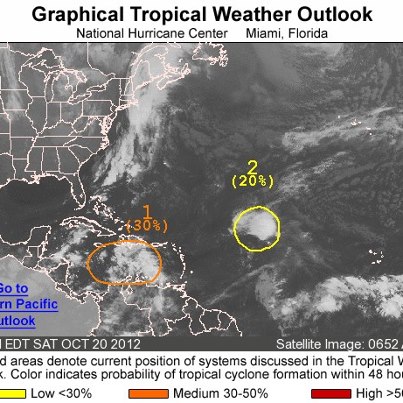
- NHC is monitoring two areas of disturbed weather over the Atlantic basin on this Friday afternoon.
The first is a tropical wave located over the central Atlantic Ocean midway between the northern Lesser Antilles and the Cape Verde Islands....It's interacting with an upper-level low to produce widespread clouds and thunderstorms. The system has a low chance of becoming a tropical cyclone during the next 48 hours as it moves slowly toward the west-northwest or northwest.See More
The second is an area of disturbed weather over the central and eastern Caribbean Sea associated with a westward-moving tropical wave. It also has a low chance of becoming a tropical cyclone during the next 48 hours.
Get the latest on the tropics anytime by visiting the NOAA NHC website at www.hurricanes.gov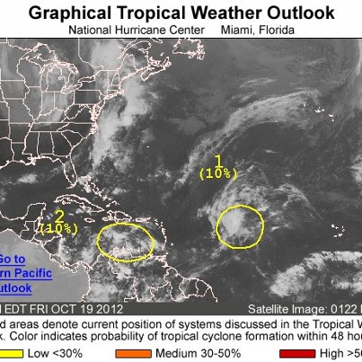
- Over the Atlantic basin this morning, an area of disturbed weather associated with a tropical wave is located midday between the Cape Verde Islands and the Lesser Antilles. Development, if any, will be slow to occur. The system has a low c...hance of becoming a tropical cyclone during the next 48 hours as it moves slowly toward the west-northwest or northwest.See More
Meanwhile, the eastern North Pacific basin is quiet.
Get the latest on the tropics anytime by visiting the NOAA NHC website at www.hurricanes.gov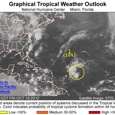
- Across the Atlantic basin this morning, there is no potential for tropical cyclone development for the next 48 hours. The same is true for the eastern North Pacific basin.
Get the latest on the tropics anytime by visiting the NOAA NHC website at www.hurricanes.gov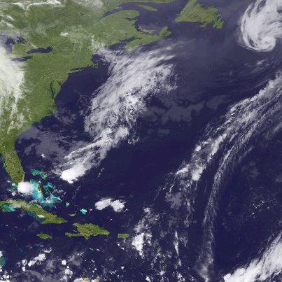
- NHC has issued its last advisory on "Rafael" over the North Atlantic as the system has lost its tropical characteristics. In this photo, it is centered about 475 miles southeast of Nova Scotia. Maximum sustained winds are 75 mph. Although w...eakening is expected, it will remain a powerful extratropical low over the North Atlantic for several more days.See More
NHC has also issued its last advisory on "Paul" over the eastern North Pacific, as the system is now a remnant low off the west coast of the Baja California Peninsula.
Get the latest on the tropics anytime by visiting the NOAA NHC website at www.hurricanes.gov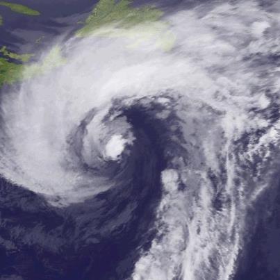
- NHC has downgraded Tropical Storm Paul to a tropical depression, centered at midday about 85 miles southeast of Punta Eugenia, Mexico. The government of Mexico has discontinued all coastal watches and warnings.
Maximum sustained winds ar...e 35 mph. Continued weakening is forecast, and Paul should degenerate to a remnant low later today or tonight.See More
The depression will continue to move toward th northwest along the coast of Baja California del Sur this afternoon, then move over the open Pacific Ocean tonight.
Get the latest on this system, including graphics and impacts, on the NOAA NHC website at www.hurricanes.gov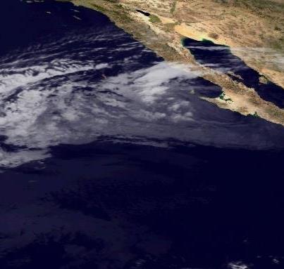
- Hurricane Rafael is moving over the North Atlantic Ocean, centered at midday about 545 miles south-southeast of Halifax, Nova Scotia. Maximum sustained winds are 75 mph, a Category One hurricane on the Saffir-Simpson Hurricane Wind Scale. R...afael is forecast to lose its tropical characteristics later today. However, it will remain a powerful extratropical low over the North Atlantic for several days. Rafael is moving toward the north-northeast at 35 mph, and a turn toward the northeast at a faster forward speed is expected later today.See More
Get the latest on Rafael, including graphics, on NOAA NHC website at www.hurricanes.gov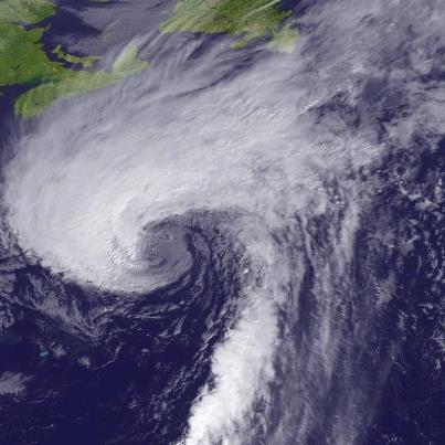
- Tropical Storm Paul is skirting the southwest coast of Baja California Sur, centered this morning about 120 miles west-northwest of Loreto, Mexico. It's forecast to move northwest along the west coast of the Baja California Peninsula today....Maximum sustained winds are 45 mph. Paul should weaken to a depression later today and a remnant low tonight.See More
Get the latest on Paul, including warnings and graphics, on the NOAA NHC website at www.hurricanes .gov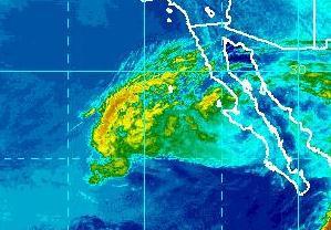
- Hurricane Rafael is located over the North Atlantic Ocean, centered this morning about 310 miles northeast of Bermuda. Maximum sustained winds are 80 mph, a Category One hurricane on the Saffir-Simpson Hurricane Wind Scale. Some weakening i...s forecast, and Rafael could lose its tropical characteristics later today. However, it will remain a powerful post-tropical cyclone for several days. It is moving toward the north-northeast at more than 30 mph, and a turn toward the northeast is expected later today.See More
Get the latest on Rafael, including graphics, on NOAA NHC website at www.hurricanes.gov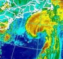
- Hurricane Paul is centered this evening just 10 miles south of Cabo San Lazaro on the west coast of the Baja California Peninsula, moving north at 15 mph. Paul is expected to move near or over the west coast of Baja California Peninsula for...the next 12 hours. A Hurricane Warning continues on the Peninsula from Santa Fe to Punta Abreojos and from Evaristo to Mulege. Residents should remain in a secure place until the storm is over.See More
Maximum sustained winds are 75 mph - a Category One hurricane on the Saffir-Simpson Hurricane Wind Scale. Weakening is expected as Paul moves over the higher terrain of Baja California Peninsula.
Get the very latest on this hurricane, including warnings, graphics and expected impacts, on the NOAA NHC website at www.hurricanes.gov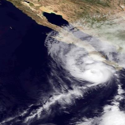
- Hurricane Rafael will spread winds of tropical-storm-force across Bermuda this evening. However, sustained hurricane-force winds will not impact the island. Rafael is centered this evening about 130 miles south-southeast of Bermuda, moving ...toward the north-northeast at more than 25 mph, and will be passing east of Bermuda this evening. Maximum sustained winds are 85 mph - a Category One hurricane on the Saffir-Simpson Hurricane Wind Scale. Slow weakening is forecast and Rafael could lose its tropical characteristics by late Wednesday or Thursday.See More
Get the latest on this hurricane, including graphics, on the NOAA NHC website at www.hurricanes.gov
- The rains from Hurricane Rafael have begun in Bermuda this afternoon. The center of the hurricane is located about 195 miles south of Bermuda, moving toward the north-northeast at 23 mph. A Tropical Storm Warning continues for Bermuda. Trop...ical storm conditions are expected to begin this afternoon or evening. Sustained hurricane-force winds are not expected on the island as the center of Rafael passes east of Bermuda this evening.See More
Maximum sustained winds are 85 mph, a Category One hurricane on the Saffir-Simpson Hurricane Wind Scale. Slow weakening is forecast during the next 48 hours.
Get the latest on this hurricane, including graphics, on the NOAA NHC website at www.hurricanes.gov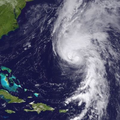
- Hurricane Paul is approaching Cabo San Lazaro on the west coast of the Baja California Peninsula, centered about 45 miles south of that city and moving north at 18 mph. Landfall is expected in just a few hours. A Hurricane Warning continue...s on the Peninsula from Santa Fe to Punta Abreojos and from Evaristo to Mulege. Preparations to protect life and property should now be complete in the warning area, and you should stay in a secure place until the storm is over.See More
Maximum sustained winds are 90 mph - a strong Category One hurricane on the Saffir-Simpson Hurricane Wind Scale. No signiifcant change in strength is expected before landfall, with weakening to occur while Paul moves over the higher terrain of Baja California Peninsula.
Get the very latest on this hurricane, including warnings, graphics and expected impacts, on the NOAA NHC website at www.hurricanes.gov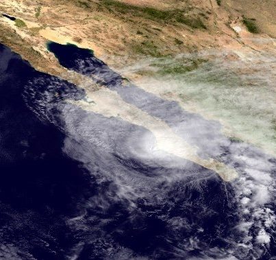
- The outer rainbands of Hurricane Rafael are appoaching Bermuda at midday. The center is located about 255 miles south of Bermuda, moving toward the north-northeast at 24 mph. A turn toward the northeast at an even faster forward speed shoul...d occur by tomorrow. That will take the center of the hurricane east of Bermuda late this afternoon and evening.See More
A Tropical Storm Warning continues for Bermuda. Tropical storm conditions are epxected to begin there by this afternoon or evening. Sustained hurricane-force winds are not expected on the island.
Maximum sustained winds are 90 mph, a solid Category One hurricane on the Saffir-Simpson Hurricane Wind Scale. Some weakening is forecast during the next 48 hours.
Get the latest on this hurricane, including graphics, on the NOAA NHC website at www.hurricanes.gov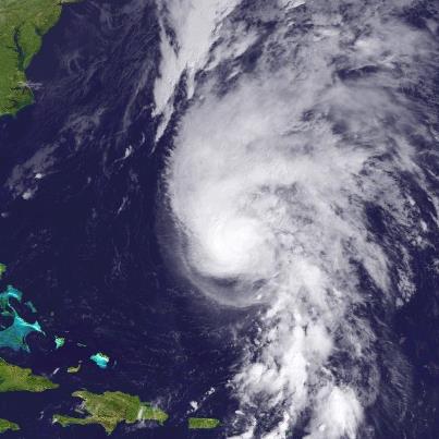
- Hurricane Paul is aiming toward the Baja California in a hurry, moving toward the north-northeast at 20 mph. A Hurricane Warning has been issued by the government of Mexico for the east coast of the Baja Peninsula from San Evaristo to Muleg...e, and continues on the west coast of the Peninsular from Santa Fe to Punta Abreojos. Preparations to protect life and property in the warning area should be rushed to completion. Hurricane conditions will begin there in just a few hours.See More
Maximum sustained winds are 105 mph - a Category Two hurricane on the Saffir-Simpson Hurricane Wind Scale. No significant change in strength is expected before landfall this afternoon.
Get the very latest on this hurricane, including warnings, graphics, and expected impacts, on the NOAA NHC website at www.hurricanes.gov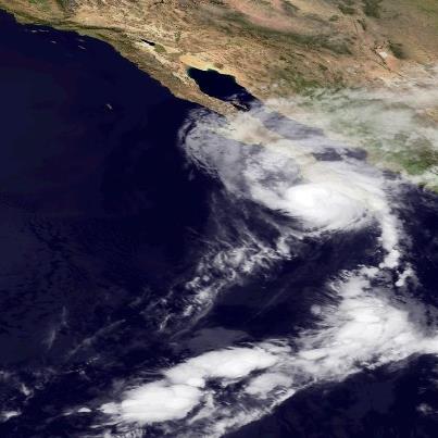
- Hurricane Paul is moving a little faster toward the north-northeast this morning, centered about 200 miles south of Cabo San Lazaro, Mexico. A Hurricane Warning continues along the west coast of Baja California from Santa Fe to Punta Abreoj...os. Preparations to protect life and property there must be rushed to completion.See More
The center of Paul is expected to be near or over the west coast of the Baja Peninsula in the warning area by tonight.
Maximum sustained winds are 110 mph - a strong Category Two hurricane on the Saffir-Simpson Hurricane Wind Scale. Paul should weaken some today but will still be a hurricane at landfall.
Go to the NOAA NHC website at www.hurricanes.gov for the very latest information on this hurricane.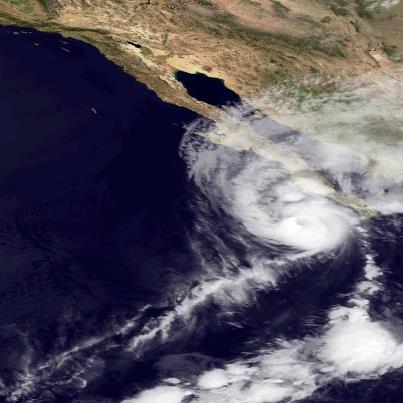
- Hurricane Rafael is centered about 395 miles south of Bermuda this morning, moving a little faster toward the north-northeast. A turn toward the northeast at an even faster forward speed is expected tonight, taking the center of this hurric...ane just east of Bermuda late this afternoon through this evening. A Tropical Storm Warning continues for Bermuda, and weather conditions will deteriorate on that island later this afternoon.See More
Maximum sustained winds are 85 mph - a Category One hurricane on the Saffir-Simpson Hurricane Wind Scale. Little change in strength is forecast for today.
Get the latest information, including graphics, on the NOAA NHC website at www.hurricanes.gov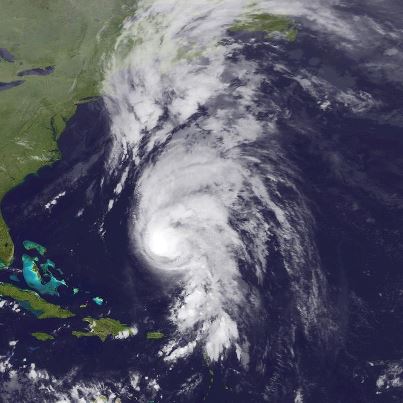
- NHC has upgraded "Rafael" to a hurricane tonight. Reports from both a NOAA and USAF Hurricane Hunter aircraft indicate maximum sustained winds have reached 85 mph - a Category One hurricane on the Saffir-Simpson Hurricane Wind Scale. Littl...e change in strength is expected tonight and Tuesday. The hurricane is centered about 545 miles south of Bermuda, moving toward the north. A turn toward the northeast is expected Tuesday. A Tropical Storm Warning continues for Bermuda.See More
Get the latest on this hurricane, including graphics, on the NOAA NHC website at www.hurricanes.gov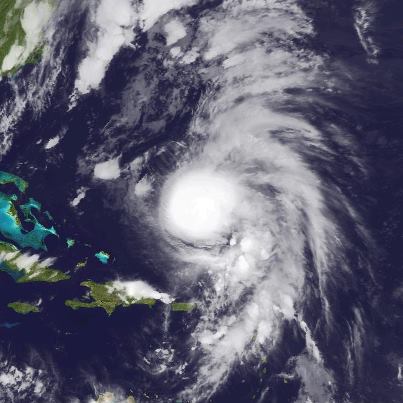
- Hurricane Paul is now a major hurricane with 120 mph winds, centered tonight about 415 miles south of the southern tip of Baja California, and moving toward the north-northeast. A Hurricane Warning has been issued for portions of the west coast of the Baja Peninsula.
Go to the NOAA NHC website for the latest information on this storm, including forecasts and graphics, at www.hurricanes.gov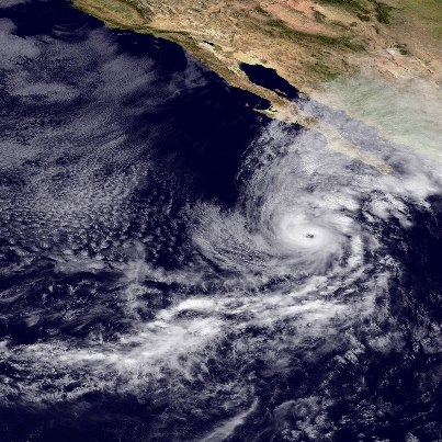
- Tropical Storm Rafael has turned north, centered this evening about 570 miles south of Bermuda. Maximum sustained winds remain at 70 mph. Both a NOAA and a USAF Hurricane Hunter aircraft are en route to investigate the storm. Rafael is exp...ected to turn more toward the northeast tomorrow. On that track, the center of Rafael will past near or just east of Bermuda late Tuesday or Tuesday Night. A Tropical Storm Warning continues for Bermuda. Rafael could become a hurricane tonight or Tuesday.See More
Get the latest on this storm, including graphics, on the NOAA NHC website at www.hurricanes.gov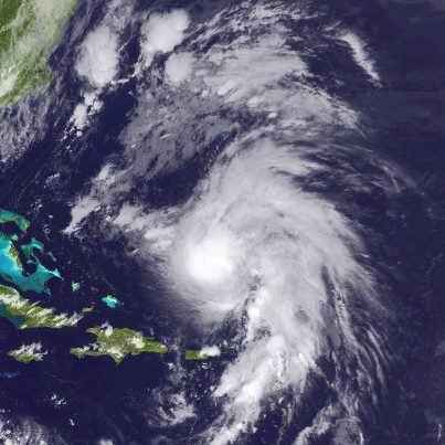
- The ribbon is being cut today at NOAA's new Center of Weather and Climate Prediction, located on the grounds of the University of Maryland in College Park. The 268,000 square-foot building is home to more than 800 employees of NOAA, providi...ng the nation with a broad range of environmental services. This includes NOAA's Climate Prediction Center, which creates the hurricane seasonal outlook for the Atlantic, eastern North Pacific and Central North Pacific Oceans. NOAA's Hydrometeorological Prediction Center is also housed there, forecasting the large scale weather patterns.See More
Here is the link to the press release: http://www.noaanews.noaa.gov/stories2012/20121015_ncwcp.html
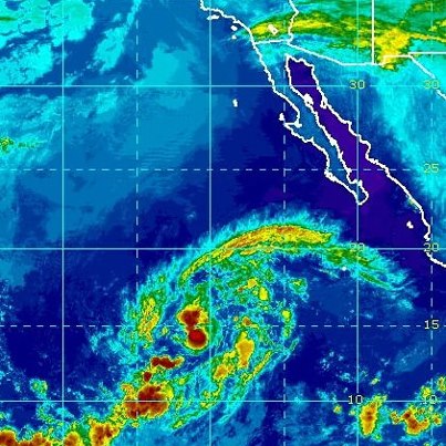
- Over the eastern North Pacific Ocean, Hurricane Paul continues to strengthen. Maximum sustained winds 90 mph, a strong Category One hurricane on the Saffir-Simpson Hurricane Wind Scale. Some additional strengthening is possible during the ...next 24 hours, with weakening after that.See More
Paul is centered about 495 miles southwest of the southern tip of Baja California, moving toward the north. A north to northeast movement is expected during the next day or so.
The government of Mexico has issued a Tropical Storm Warning for the west coast of the Baja Peninsula from Sante Fe to Puerto San Andresito, Mexico. A Tropical Storm Watch runs north from San Andresito to El Pocito.
Tropical storm conditions are expected in the warning area by Tuesday afternoon, and those conditions are possible in the watch area by late Tuesday or early Wednesday.
Get the latest on this hurricane, including watches, warnings and graphics, on the NOAA NHC website at www.hurricanes.gov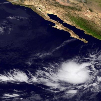
- Tropical Storm Rafael is located at midday about 645 miles south of Bermuda, moving toward the north-northwest. A turn toward the north is forecast for this afternoon or evening, then northeast on Tuesday. On that track, the center of Rafae...l will remain well to east of the Bahamas and approach Bermuda on Tuesday.See More
The Bermuda Weather Service has issued a Tropical Storm Warning for Bermuda. Tropical storm conditions are expected in there within 36 hours.
Rafael has maximum sustained winds of 70 mph, and the storm is expected to become a hurricane later today or tonight.
Rafael should produce additional rainfall amounts of 1 to 3 inches over the northern Leeward Islands, with isolated storm totals up to 12 inches possible. These rains could cause life-threatening flash flood and mud slides, especially over mountainous terrain.
Get the latest on this storm, including warnings and graphics, on the NOAA NHC website at www.hurricanes.gov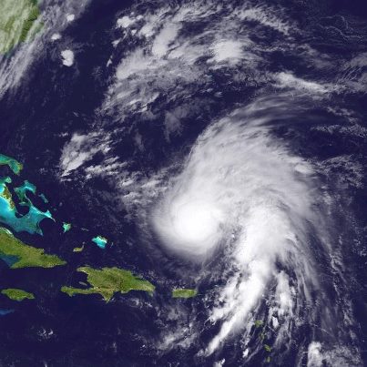
- Data from an Air Force Reserve Hurricane Hunter Aircraft indicate that Tropical Storm Rafael is strengthening this evening. Maximum sustained winds have increased to near 65 mph and the storm is located about 760 miles south of Bermuda. S...ome of Rafael's rain bands are still affecting portions of the northern Leeward Islands and rainfall totals of 4 to 8 inches with isolated maximum amounts of 12 inches are possible in the these areas. The forecast track brings Rafael near Bermuda on late Tuesday and a tropical storm watch is in effect for that island.See More
Meanwhile, in the eastern Pacific Ocean Tropical Storm Paul is located about 625 miles south of the southern tip of Baja California. Paul is forecast to strengthen as it moves northward and interests in Baja California should monitor the progress of this storm.
The latest information on both of these systems can be found at the NOAA NHC website at hurricanes.gov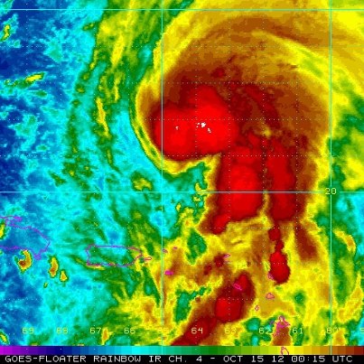
- The center of Rafael is now located north of the Leeward Islands, about 100 miles north-northwest of St. Martin. Heavy rainfall and gusty winds will continue across much of the Leeward Islands today as the center of Rafael gradually moves ...away from the area. Rainfall totals of 3 to 5 inches with isolated maximum amounts of 10 inches are possible over the Lesser Antilles and the Virgin Islands.See More
In the eastern Pacific Ocean, Tropical Storm Paul is located about 665 miles south of the southern tip of the Baja Peninsula. Paul has maximum winds of 50 mph and the storm is forecast to turn northwestward, then northward during the next day or so.
For the latest information of these tropical cyclones, visit the NOAA NHC website at hurricanes.gov
- Rafael is located about 55 miles south-southwest of St. Martin late this afternoon. Data from an Air Force Reserve Hurricane Hunter Aircraft indicate that the maximum winds have increased to near 50 mph. Tropical storm conditions will spr...ead across portions of the Leeward Islands tonight and rainfall amounts of 3 to 5 inches with isolated maximum totals of 10 inches are also expected.See More
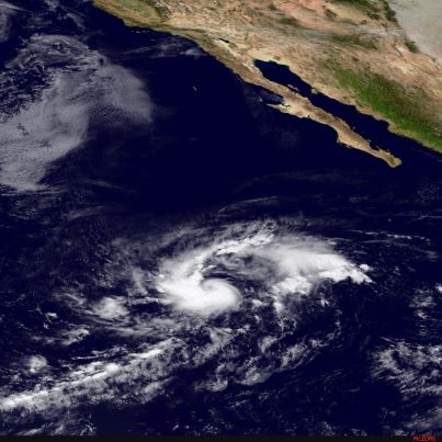
The NHC has also initiated advisories on newly formed Tropical Storm Paul in the eastern Pacific Ocean. Paul is located about 660 miles south-southwest of the southern tip of the Baja Peninsula. Paul is forecast to turn northwestward, then northward during the next couple of days.
For the latest information on both of these storms, please visit the NOAA NHC website at www.hurricanes.gov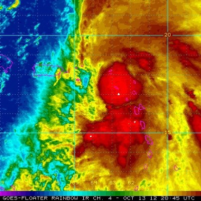
- Tropical Storm Rafael is now moving toward the north-northwest, centered over the eastern Caribbean Sea at midday about 135 miles south-southeast of St. Croix. The forecast track brings the center of the storm near or over the Virgin Island...s tonight. Tropical Storm Warnings have been extended to include Culebra and Vieques, and continue for the British and U.S. Virgin Islands, as well as a number of islands in the Lesser Antilles. A Tropical Storm Watch continues for Puerto Rico.See More
Tropical storm conditions will spread across the warning area of the Lesser Antilles and Virgin Islands today, and across Culebra and Vieques tonight. Tropical storm conditions are possible over Puerto Rice tonight and Sunday.
Maximum sustained winds are 40 mph. Some slow strengthening is possible during the next two days.
Total rainfall amounts of 2 to 5 inches, with isolated 10 inch amounts, are possible over the Lesser Antilles, Virgin Islands, Culebra and Vieques, producing life-threatening flash flood and mudslides, especially in mountainous regions.
Get the latest on the storm, including watches, warnings, and graphics, on the NOAA NHC website at www.hurricanes.gov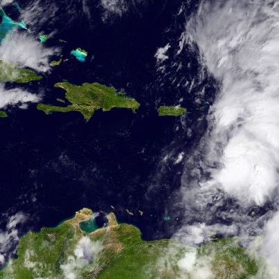
- Heavy rain continues to fall over the Lesser Antilles this morning due to Tropical Storm Rafael. A USAF Hurricane Hunter aircraft located the center about 165 miles south-southeast of St. Croix, moving toward the northwest. A turn toward t...he north-northwest is expected later today. On that track, the center should move near or over the Virgin Islands tonight.See More
Tropical Storm Warnings continue for the British and U.S. Virgin Islands, as well as a number of islands in the Lesser Antilles. A Tropical Storm Watch includes Puerto Rico.
Tropical storm conditions are expected in the warning area today, and possibly in the watch area tonight and Sunday.
Maximum sustained winds are 40 mph. Some slow strengthening is possible during the next two days.
Total rainfall amounts of 2 to 5 inches, with isolated 10 inch amounts, are possible over the Lesser Antilles and Virgin Islands, producing life-threatening flash flood and mudslides, especially in mountainous regions.
Get the latest on the storm, including watches, warnings, and graphics, on the NOAA NHC website at www.hurricanes.gov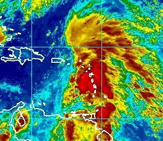
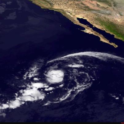
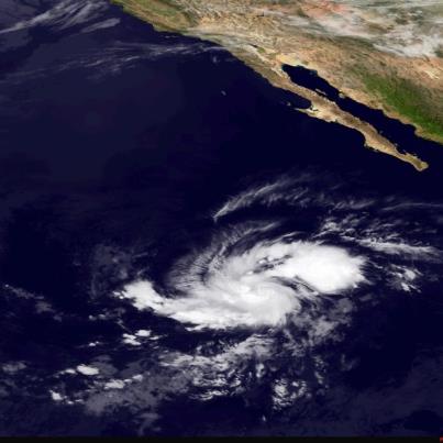
- Over the eastern North Pacific Ocean this morning, an area of low pressure located about 500 miles south of the southern tip of Baja California is becoming better defined. This system has a high chance of becoming a tropical cyclone during the next 48 hours as it moves toward the west.
Get the latest on the tropics anytime by visiting the NOAA NHC website at www.hurricanes.gov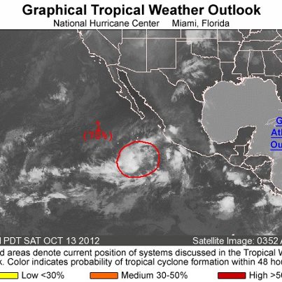
- Tropical Depression Patty remains stalled this morning, centered over the southwest Atlantic Ocean about 280 miles east-northeast of the central Bahamas.
Maximum sustained winds are 35 mph. Strong southwesterly wind shear will continue to...weaken the depression, and Patty should become a remnant low later today before dissipating by tomorrow.See More
Get the latest on this system, including graphics, on the NOAA NHC website at www.hurricanes.gov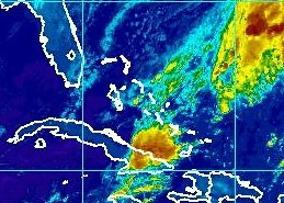
- Tropical Storm Rafael is spreading heavy rain over the Lesser Antilles tonight. It's centered over the eastern Caribbean Sea about 140 miles west of Dominica, moving toward the northwest at 10 mph. On the forecast track, the center will mov...e across the eastern Caribbean Sea overnight tonight and Saturday and be near or over the Virgin Islands Saturday Night. Tropical Storm Warnings continue for the British and U.S. Virgin Islands, as well as a number of islands in the Lesser Antilles. A Tropical Storm Watch includes Puerto Rico.See More
Tropical storm conditions are expected in the warning area overnight and Saturday, and possibly in the watch area Saturday Night and Sunday.
Maximum sustained winds are 40 mph. Some slow strengthening is possible Saturday through Sunday.
Get the latest on the storm, including watches, warnings, and graphics, on the NOAA NHC website at www.hurricanes.gov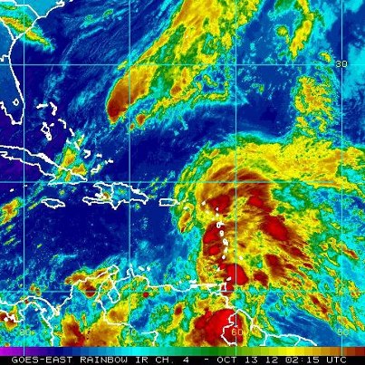
- NHC is now issuing advisories on newly formed Tropical Storm Rafael, centered about 125 miles west-southwest of Dominica.
Tropical Storm Warnings have been issued for the British and U.S. Virgin Islands, as well as a number of islands in th...e Lesser Antilles. A Tropical Storm Watch includes Puerto Rico.See More
Rafael is moving toward the north-northwest, with a turn toward the north expected on Saturday. On that forecast track, the center will move across the eastern Caribbean Sea tonight and be near or over the Virgin Islands Saturday or Saturday Night. Tropical storm conditions are expected in the warning area tonight and Saturday, and possibly in the watch area Saturday Night and Sunday.
Maximum sustained winds are 40 mph. Some slow strengthening is possible Saturday through Sunday.
Get the latest on the storm, including watches, warnings, and graphics, on the NOAA NHC website at www.hurricanes.gov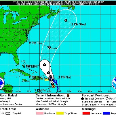
- A USAF Hurricane Hunter plane is investigating the area of low pressure located over the eastern Caribbean Sea about 100 miles west-southwest of Dominica.
Preliminary data from the aircraft indicate that the low could be developing a well-d...efined center. Tropical-storm-force winds are occurring near portions of the Windward Islands.See More
If the existence of a center is confirmed, NHC will initiate advisories on Tropical Storm "Rafael". Tropical Storm Warnings would then be needed for portions of the Lesser Antilles and the Virgin Islands.
Regardless of development, strong gusty winds and heavy rainfall are possible in those areas during the next couple of days as the system moves toward the northwest to north-northwest.
Keep up with the latest on this system on the NOAA NHC website at www.hurricanes.gov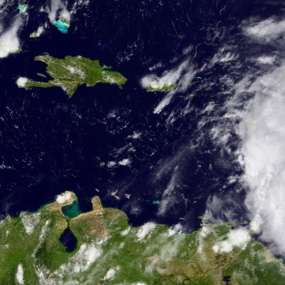
- NHC has downgraded Tropical Storm Patty to a tropical depression, as the increasing wind shear over the system takes it toll. Maximum sustained winds are now 35 mph. Further weakening is expected, and Patty could become a remnant low in 24 ...hours, if not sooner. It's centered tonight about 265 miles east-northeast of the central Bahamas and has moved very little today. A west-southwest motion is expected on Saturday and continuing through its dissipation.See More
Get the latest information, including graphics, on the NOAA NHC website at www.hurricanes.gov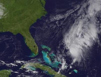
- NHC is issuing advisories on Tropical Storm Patty, centered about 275 miles east-northeast of the central Bahamas.
Elsewhere, the broad area of low pressure located over the eastern Caribbean Sea about 100 miles west of Dominica is still p...roducing a large area of showers and thunderstorms over portions of the Lesser Antilles. The system still does not have a closed low-level circulation, but upper-level winds are expected to become conducive for development, and it is likely that a tropical depression or tropical storm will form during the next day or two as the system moves toward the northwest or north-northwest. If this occurs, a tropical storm warning would be required for portions of the Leeward Islands. A USAF Hurricane Hunter plane will investigate the system this afternoon.See More
Strong gusty winds and heavy rainfall are possible across portions of the Lesser Antilles and Virgin Islands during the next couple of days.
Get the latest on the tropics on visiting the NOAA NHC website at www.hurricanes.gov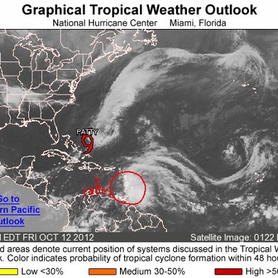
- Tropical Storm Patty is located about 275 miles east-northeast of the central Bahamas at midday. Maximum sustained winds are 40 mph. Slow weakening is forecast during the next 48 hours, and Patty could become a remnant low before Sunday - t...he result of a combination of strong wind shear and drier and more stable air being pulled into it.See More
Patty is not expected to move much today, with a southwest motion forecast on Saturday. A USAF Hurricane Hunter plane will investigate the system shortly to provide more detailed data on the storm.
Get the latest information, including graphics, on the NOAA NHC
website at www.hurricanes.gov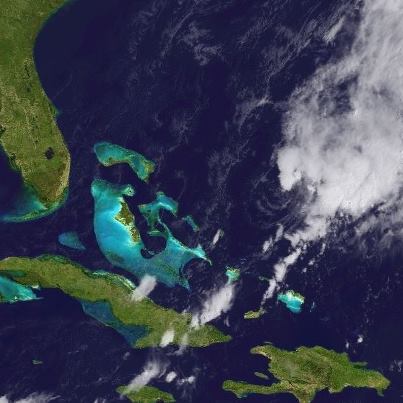
- A broad area of low pressure is located over the eastern Caribbean Sea this morning, centered about 60 miles northwest of St. Lucia.
Although the system is likely producing winds to tropical storm force in the rain bands, the satellite an...d surface data suggest that the low still does not have a closed circulation.See More
Upper-level winds are forecast to become more conducive for development, and it has a high chance of becoming a tropical cyclone during the next 48 hours while moving toward the northwest or north-northwest. A tropical storm warning could be required for portions of the Leeward Islands.
Strong and gusty winds along with heavy rainfall are possible across portions of the Lesser Antilles during the next couple of days.
A USAF Hurricane Hunter plane is scheduled to investigate the system this afternoon.
Get the latest on the tropics anytime by visiting the NOAA NHC website at www.hurricanes.gov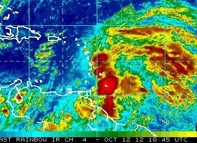
- Tropical Storm Patty is weakening, centered this morning about 230 miles east-northeast of the central Bahamas. Maximum sustained winds are 40 mph. Further weakening is likely, and Patty could become a remnant low by Saturday. A slow southw...est to south-southwest movement is forecast for today, with a little increase in the forward speed on Sunday.See More
Get the latest on this storm, including graphics, on the NOAA NHC website at www.hurricanes.gov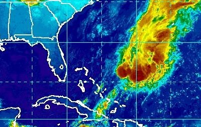
- NHC has upgraded Tropical Depression Sixteen to Tropical Storm Patty. However, the storm is not going to last long. It's centered tonight about 255 miles northeast of the central Bahamas, and expected to begin moving slowly toward the sout...hwest tonight. Maximum sustained winds are 40 mph, and little change in strength is expected tonight. On Friday, the environment will become rather hostile thanks to increasing wind shear due to upper-level southwest winds, and dry air from a cold front becoming entrained into the storm's center. These two factors will likely tear the storm apart into a trough by Friday Night.See More
Get the latest on this system, including graphics, on the NOAA NHC website at www.hurricanes.gov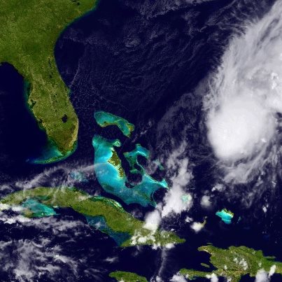
- NHC welcomes Prof. Ryan Torn this week as part of our Visiting Scientist Program. Ryan's area of expertise includes tropical cyclone genesis, effects of uncertainty upon forecasts, and tropical cyclone data assimilation. He is seen on the left side of this photo next to NHC Science and Operations Officer Dr. Chris Landsea.
Read more about the program at http://www.nhc.noaa.gov/news/20120730_pa_visitingScientists.pdf
- NHC is issuing advisories on Atlantic Tropical Depression Sixteen, located about 235 miles east-northeast of the central Bahamas.
Elsewhere, a broad area of low pressure assocated with a tropical wave is located about 100 miles southeast of...Barbados. The shower and thunderstorm activity continues to show some signs of organization, and the system has a medium chance of developing into a tropical cyclone during the next 48 hours as it moves toward the northwest. Regardless of development, strong gusty winds and heavy rainfall are possible over portions of the Lesser Antilles during the next couple of days.See More
Get the latest on the tropics anytime by visiting the NOAA NHC website at www.hurricanes.gov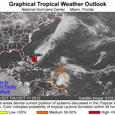
- NHC has begun to write advisories on newly-formed Atlantic Tropical Depression Sixteen. It's located at midday over the southwest Atlantic Ocean about 235 miles east-northeast of the central Bahamas. Maximum sustained winds are 35 mph. Lit...tle change in strength is expected during the next day or so...and the depression is forecast to dissipate by Friday Night.See More
It's drifting toward the south at just 1 mph. A turn toward the southwest at a slightly faster forward speed is expected later today. On that track, the center of the depression is expected to remain northeast of the central Bahamas until it dissipates Friday Night.
Get the latest on this tropical depression, including graphics, on the NOAA NHC website at www.hurricanes.gov
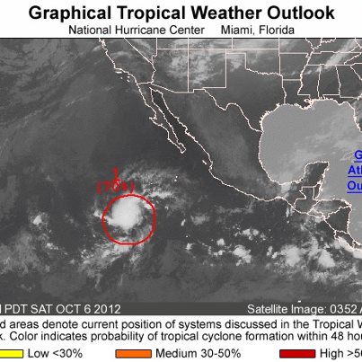
- Over the eastern North Pacific Ocean this morning, a broad area of low pressure is located about 450 miles south-southwest of Acapulco, Mexico. It has a medium chance of becoming a tropical cyclone during the next 48 hours as it moves slowly westward.
Get the latest on the tropics anytime by visiting the NOAA NHC website at www.hurricanes.gov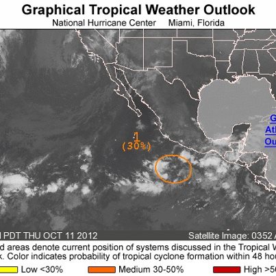
- NHC continues to monitor two areas of disturbed weather over the Atlantic basin on this Thursday.
One is a broad area of low pressure and tropical wave located about 350 miles east-southeast of the Windward Islands. This system has a mediu...m chance of developing into a tropical cyclone during the next 48 hours as it moves toward the west-northwest. Regardless of any development, strong gusty winds and heavy rainfall are possible across portions of the Lesser Antilles during the next couple of days.See More
The second area is a small area of low pressure located 250 miles northeast of the central Bahamas. There is a small window of opportunity for the system to become a tropical depression before it merges with a cold front later today while moving slowly southward.
Get the latest on the tropics anytime by visiting the NOAA NHC website at www.hurricanes.gov
- On this Wednesday afternoon, a tropical wave is located about 500 miles east of the Windward Islands. Some gradual development of this system is possible as it moves toward the west-northwest, and it has a medium chance of becoming a tropic...al cyclone during the next 48 hours. Regardless of development, gusty winds and heavy rainfall are possible over portions of the Lesser Antillies during the next couple of days.See More
Elsewhere, a weak area of low prssure located a couple of hundred miles east of the central Bahamas has become a little better defined today. Environmental conditions are only marginally conducive for development during the next day or so before it merges with a cold front Thursday Night or Friday. It has only a low chance becoming a tropical cyclone during the next 48 hours as it moves little.
Get the latest on the tropics anytime by visiting the NOAA NHC website at www.hurricanes.gov
an weak area of low pressure is located a co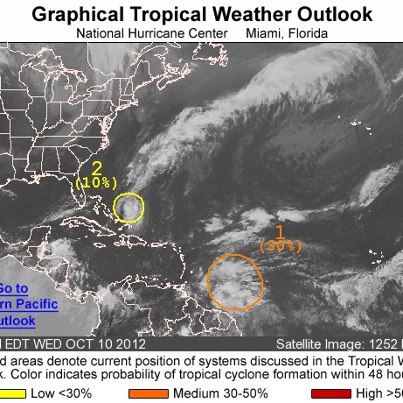
- Across the eastern North Pacific basin this morning, a trough of low pressure is located off of the coast of Central America and Mexico. Some gradual development of this system is possible as it moves slowly westward, and it has a low chance of becoming a tropical cyclone during the next 48 hours.
Get the latest on the tropics anytime by visiting the NOAA NHC website at www.hurricanes.gov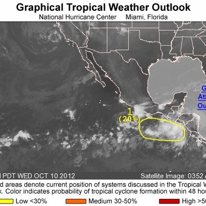
- Across the Atlantic basin this morning, NHC is monitoring a tropical wave located about 550 miles east of the Windward Islands. Some gradual development of this system is possible as it moves toward the west-northwest, and it has a medium c...hance of becoming a tropical cyclone during the next 48 hours. Interests in the Lesser Antilles should monitor the progress of this system.See More
Get the latest on the tropics anytime by visiting the NHC website at www.hurricanes.gov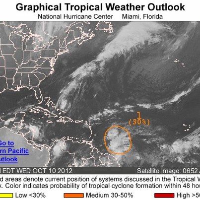
- Across the Atlantic basin on the this Tuesday, NHC continues to monitor two area of disturbed weather.
One is a weak area of low pressure located about 100 miles east of Eleuthera Island in the Bahamas. Upper levels winds are not favorable ...for development, and the system has a low chance - 10 percent - of becoming a tropical cyclone during the next 48 hours as it moves toward the northeast and away from the Bahamas.See More
The second area is a tropical wave and broad area of low pressure located about 1000 miles east of the Windward Islands. Any development of this system will be slow to occur due to a marginally conducive environment. It has a low chance - 20 percent - of developing into a tropical cyclone during the next 48 hours as it moves toward the west-northwest.
Get the latest on the tropics anytime by visiting the NOAA NHC website at www.hurricanes.gov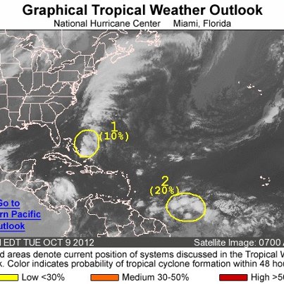
- Tropical Storm Olivia has stalled tonight over the eastern North Pacific Ocean, centered about 865 miles west-southwest of the southern tip of Baja California. Maximum sustained winds are now down to 45 mph. Olivia should weaken further to ...a tropical depression tonight and a remnant low during the next day or so. It is not a threat to land.See More
Get the latest on this storm, including graphics, on the NOAA NHC website at www.hurricanes.gov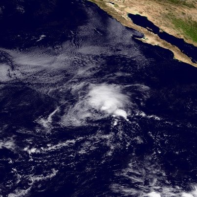
- NHC is currently monitoring two areas of disturbed weather.
One is a trough of low pressure extending from the southeastern Bahamas into the southwest Atlantic. Upper-level winds are expected to becoming less conducive for development, so i...t has a low chance - 10 percent - of becoming a tropical cyclone during the next 48 hours while moving toward the northwest.See More
The second area is a tropical wave and broad area of low pressure located about 1600 miles east-southeast of the Lesser Antilles. Development - if any - will be slow to occur as it moves towards the west or west-northwest. It also has a low chance - 10 percent - of developing into a tropical cyclone during the next 48 hours.
Get the latest on the tropics anytime by visiting the NOAA NHC website at www.hurricanes.gov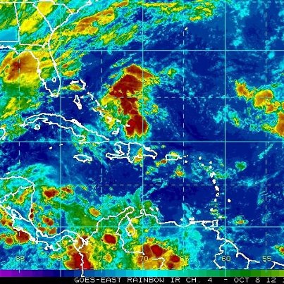
- Tropical Storm Olivia is centered over the eastern North Pacific Ocean this morning about 845 miles southwest of the southern tip of Baja California. The storm is maintaining is 60 mph winds but weakening is expected to begin today, and Oli...via could become a tropical depression by tomorrow night. Its slow northward movement will become stationary tonight, then west-southwest on Tuesday. Olivia is not a threat to land.See More
Get the latest on this storm, including graphics, on the NOAA NHC website at www.hurricanes.gov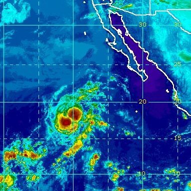
- Tropical Storm Olivia is located over the eastern North Pacific Ocean, centered tonight about 875 miles southwest of the southern tip of Baja California. Maximum sustained winds are 60 mph. Some strengthening is still possible into Monday b...efore weakening starts on Monday Night. A slow northward motion is expected tonight and Monday, then a turn toward the west on Monday Night into Tuesday. Olivia is not a threat to land.See More
Get the latest on this storm, including graphics, on the NOAA NHC website at www.hurricanes.gov