|
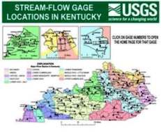
Real-Time Data for Kentucky
NOTICE: Recently discontinued and threatened USGS streamgages in Kentucky. Click here
for more information.
Historical Data
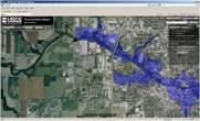
Current Water Conditions

National Water Conditions
Hydrology Tools
For those unable to view the graphical map, the same information is available via the USGS-KY NWISWeb site inventory page.
Recent Products
USGS Products and Information
Social Media Links

|
|
Science Highlights
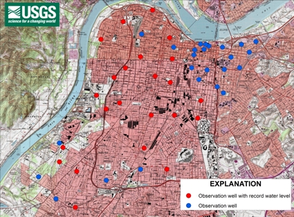
Record Groundwater Levels in the Louisville Area
 (Click image above for larger map) [PDF file - ~34MB]
Record high groundwater levels have been measured recently for portions of the alluvial aquifer beneath Louisville, Kentucky. In March 2012, a team of scientists from the Kentucky Water Science Center of the U.S. Geological Survey (USGS) measured the depth to water in 48 groundwater observation wells to ascertain the current elevation of the water table in the alluvial deposits beneath Louisville.
New high water levels were recorded for 23 of the 48 wells.
Recent above average annual precipitation amounts for the Louisville metro area have contributed to these record groundwater levels. But while some areas of the aquifer are at record levels, the water table in the downtown area remains near average elevation due in part to the pumping of ground water for the heating and cooling of some buildings. Should groundwater levels continue to rise or pumping in the downtown area decreases, inundation of man-made structures can cause significant structural settlement problems, damage to foundations and basements, and disruption of utility services such as gas, electric, water, sewer, and communications.
Water-level data have been collected in the alluvial aquifer at Louisville by the USGS since 1943. Interpretations of these data are published periodically to update the record and help manage this groundwater resource.
|
U.S. Geological Survey Indiana-Kentucky Water Science Center Commonwealth Strategic Science Plan, 2012-2017
 |
|
The USGS Indiana and Kentucky WSCs work together closely, under one Director, within a “Commonwealth” model. The Indiana-Kentucky WSC Commonwealth is organized with a Deputy Director in each State office who reports to the Director. Technical and support staff in each State report to the Deputy Director. The combined staff of the Commonwealth is approximately 100 employees, which is composed of hydrologists, research hydrologists, hydrologic technicians, biologists, geospatial specialists, management, administration, and information technology support personnel. The USGS Indiana WSC office is located in Indianapolis, Indiana. The USGS Kentucky WSC consists of three offices: Louisville, Kentucky (main office), Murray, Ky. (field office), and Williamsburg, Ky. (field office).
|
The USGS Indiana–Kentucky Water Science Center Commonwealth provides reliable hydrologic and water-related ecological information to aid in the understanding of the use and management of water resources in Indiana, Kentucky, and the Nation. Input for the new 3–5 year Commonwealth strategic science plan was received from cooperators, stakeholders, and staff and was considered in the development of the objectives and strategic actions (for the next 3-5 years) for each of six science-focus areas:
- Hydrologic Monitoring Networks: Optimizing and expanding Indiana and Kentucky surface-water, groundwater, water-quality, and precipitation networks in order to provide a foundation for activities within the other five science-focus areas.
- Hazards: Building geospatial tools for hazards monitoring, investigating stream dynamics and erosion hazards, studying karst hazards, investigating transport and fate of contaminants, and investigating dam and levee stability.
- Ecosystems Science: The establishment of “supergage” monitoring stations, investigating drivers of ecosystem health, studying broad regional issues such as Gulf of Mexico hypoxia, and studying emerging issues that affect ecosystem health.
- Water Availability and Demand: Developing data and interpretive products for water management; addressing groundwater-data needs; determining impacts of climate change; and evaluating relations between landscapes, water withdrawal and returns, streamflow, and ecological functions.
- Energy Production and Impacts: Convening professional meetings dedicated to understanding the impact of energy production on water resources, developing techniques of ecological assessment for sites impacted by energy production, strengthening geophysical capabilities for studies of energy production and refuse storage, developing an understanding of soil-gas intrusion, and assessing the impact of biofuel crops on water quality and quantity.
- Public Health: Increasing the understanding of public health related to water resources, applying technologies for identifying and measuring pathogens at beaches and within watersheds, and using fate and transport models to enhance methods of assessing environmental impacts of influences on public health.
Center for Applied Hydrologic Solutions
The Center for Applied Hydrologic Solutions (CAHS) is jointly located within the USGS Kentucky and Indiana Water Science Centers in Louisville, Kentucky and Indianapolis, Indiana respectively. CAHS is dedicated to developing high-end spatial and information-technology applications that leverage defensible USGS science to create partner-driven applications that pair with modern technologies.
|
|
|
Featured Local Project
Ohio River Alluival Aquifer - Groundwater Network
|
Water-level data for the alluvial aquifer at Louisville, Kentucky, have been collected by the USGS in cooperation with various local and State agencies since September 1943. Data are presently being collected in cooperation with the Louisville Water Company. Special attention is given to the northeast portion of the alluvial aquifer where the Louisville Water Company is beginning to use riverbank filtration wells [refer to the photograph to the right] to draw water from the Ohio River through the aquifer at their B.E. Payne Water Treatment Plant near Prospect, Kentucky.
To monitor the groundwater levels, twenty-eight existing wells were incorporated
into an observation well network. This network is measured quarterly. Twelve of the
observation wells are equipped with continuously recording pressure transducers
that measure water levels and water temperature. Hydrographs from the continuous
recorder wells depict the trends in the groundwater levels. |
|

A Louisville Water Company riverbank infiltration well.
|
Collaborative Projects
Water Availability Tool for Environmental Resources
 |
|
The Water Availability Tool for Environmental Resources (WATER) was developed in cooperation with the Kentucky Division of Water to provide a consistent and defensible method of estimating streamflow, water availability, and other hydrologic information in ungaged basins. |
WATER automatically incorporates and processes large amounts of basic and custom geospatial data to quantitatively describe topography, soil-water storage, climate, streamflow, and other parameters. WATER is also designed so that it can be expanded for other science and regulatory applications including, but not limited to, sediment and nutrient loads, evaluation of surface mining effects (Cumulative Hydrologic Impact Assessments), as well as flows that are necessary for ecological viability.
The concept of the Kentucky WATER application was born from the need to quantify water availability in areas of the Kentucky Commonwealth with limited long-term monitoring data. Kentucky's wealth of geospatial data was critical to the Kentucky WATER application and enabled USGS scientists to take well-known streamflow generation and modeling concepts (Beven and Kirby, 1979), develop innovative dataprocessing methods, and apply the concept across all regions of Kentucky with much greater accuracy and precision than had been previously possible.
WATER Users Group Community Wiki (public download site)
View the project page link above to learn more about how the USGS can help you manage your water resources by providing custom input data, user-friendly interfaces, and tailored output to meet your specific management needs through "WATER".
Kentucky Agriculture Science and Monitoring Committee
 |
|
The Kentucky Agriculture Science and Monitoring Committee (KASMC) is a partnership of national, state, and local agencies dedicated to coordinating agricultural science and monitoring efforts in Kentucky in order to promote sustainable farming and a healthy environment |
National Projects
Program Cooperators
|