Skip Navigation Links weather.gov   
NOAA logo - Click to go to the NOAA homepage National Weather Service   NWS logo - Click to go to the NWS homepage
National Hurricane Center
Local forecast by
"City, St" or "ZIP"

 
Cyclone Forecasts
   Latest Advisory
   Past Advisories
   Audio/Podcasts
   About Advisories
Marine Forecasts
   Atlantic & E Pacific
   Gridded Marine
   About Marine
Tools & Data
   Satellite | Radar
   Analysis Tools
   Aircraft Recon
   GIS Datasets
   Data Archive
Development
   Experimental
   Research
   Forecast Accuracy
Outreach & Education
   Prepare
   Storm Surge
   About Cyclones
   Cyclone Names
   Wind Scale
   Most Extreme
   Forecast Models
   Breakpoints
   Resources
   Glossary | Acronyms
   Frequent Questions
Our Organization
   About NHC
   Mission | Staff
   Visitors | Virtual Tour
   Library Branch
   NCEP | Newsletter
Contact Us
   Comments
Follow the National Hurricane Cent
er on Facebook Follow the National Hurricane Center on Twitter
FirstGov.gov is the U.S. Government's official Web portal to all Federal, state and local government Web resources and services.


Monthly Atlantic Tropical Weather Summary


000
ABNT30 KNHC 020021
TWSAT 

MONTHLY TROPICAL WEATHER SUMMARY...CORRECTED
NWS NATIONAL HURRICANE CENTER MIAMI FL
800 AM EDT MON OCT 01 2012

CORRECTED LESLIE STATUS TO HURRICANE

FOR THE NORTH ATLANTIC...CARIBBEAN SEA AND THE GULF OF MEXICO...

TWO TROPICAL STORMS FORMED IN THE ATLANTIC BASIN DURING THE MONTH
OF SEPTEMBER. BOTH OF THESE REACHED HURRICANE STATUS...WHILE MICHAEL
BECAME THE FIRST MAJOR HURRICANE OF THE ATLANTIC SEASON.  THESE
TOTALS WERE BELOW THE LONG-TERM AVERAGE (1981 TO 2010) OF FOUR
NAMED STORMS AND NEAR THE LONG-TERM AVERAGES OF TWO TO THREE
HURRICANES AND ONE OR TWO MAJOR HURRICANES. 

IN TERMS OF ACCUMULATED CYCLONE ENERGY...WHICH MEASURES THE COMBINED
STRENGTH AND DURATION OF TROPICAL STORMS AND HURRICANES...TROPICAL
CYCLONE ACTIVITY SO FAR THIS YEAR IS ABOUT 50 PERCENT ABOVE THE
1981-2010 AVERAGE THROUGH THE END OF SEPTEMBER IN THE ATLANTIC
BASIN.

REPORTS ON INDIVIDUAL CYCLONES...WHEN COMPLETED...ARE AT THE WEB
SITE OF THE NATIONAL HURRICANE CENTER...USE LOWER-CASE LETTERS...
WWW.HURRICANES.GOV/2012ATLAN.SHTML
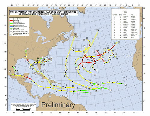
SUMMARY TABLE

NAME                DATES         MAX WIND (MPH)
---------------------------------------------------
TS ALBERTO          19-22 MAY         60
TS BERYL            26-30 MAY         70
H  CHRIS            19-22 JUN         75
TS DEBBY            23-27 JUN         60
H  ERNESTO           1-10 AUG         85
TS FLORENCE          4-6 AUG          60
H  GORDON           15-20 AUG        110
TS HELENE            9-18 AUG         45
H  ISAAC        21 AUG-1 SEP          80
TS JOYCE            22-24 AUG         40
H  KIRK         28 AUG-2 SEP         105
H  LESLIE       30 AUG-11 SEP         75
MH MICHAEL           3-11 SEP        115
H  NADINE       11 SEP-               90 
---------------------------------------------------       

$$
HURRICANE SPECIALIST UNIT


Preliminary Atlantic Tropical Cyclone Tracks


Quick Navigation Links:
Tropical Cyclone Forecasts  -  Tropical Marine Forecasts  -  Data Archive
Outreach  -  Prepare  -  About Cyclones  -  About NHC  -  Contact Us

NOAA/ National Weather Service
National Centers for Environmental Prediction
National Hurricane Center
11691 SW 17th Street
Miami, Florida 33165-2149 USA
nhcwebmaster@noaa.gov
Disclaimer
Credits
Information Quality
Glossary
Privacy Policy
Freedom of Information Act (FOIA)
About Us
Career Opportunities
Page last modified: Tuesday, 02-Oct-2012 00:21:23 UTC