Skip Navigation Links weather.gov   
NOAA logo - Click to go to the NOAA homepage National Weather Service   NWS logo - Click to go to the NWS homepage
National Hurricane Center
Local forecast by
"City, St" or "ZIP"

 
Cyclone Forecasts
   Latest Advisory
   Past Advisories
   Audio/Podcasts
   About Advisories
Marine Forecasts
   Atlantic & E Pacific
   Gridded Marine
   About Marine
Tools & Data
   Satellite | Radar
   Analysis Tools
   Aircraft Recon
   GIS Datasets
   Data Archive
Development
   Experimental
   Research
   Forecast Accuracy
Outreach & Education
   Prepare
   Storm Surge
   About Cyclones
   Cyclone Names
   Wind Scale
   Most Extreme
   Forecast Models
   Breakpoints
   Resources
   Glossary | Acronyms
   Frequent Questions
Our Organization
   About NHC
   Mission | Staff
   Visitors | Virtual Tour
   Library Branch
   NCEP | Newsletter
Contact Us
   Comments
Follow the National Hurricane Cent
er on Facebook Follow the National Hurricane Center on Twitter
FirstGov.gov is the U.S. Government's official Web portal to all Federal, state and local government Web resources and services.


Monthly Eastern North Pacific Tropical Weather Summary


000
ABPZ30 KNHC 011459
TWSEP 

MONTHLY TROPICAL WEATHER SUMMARY
NWS NATIONAL HURRICANE CENTER MIAMI FL
800 AM PDT MON OCT 01 2012

FOR THE EASTERN NORTH PACIFIC...EAST OF 140 DEGREES WEST LONGITUDE..

TROPICAL CYCLONE ACTIVITY IN THE EASTERN NORTH PACIFIC BASIN DURING
SEPTEMBER WAS ABOVE AVERAGE IN TERMS OF NAMED STORMS...AND AVERAGE
IN TERMS OF HURRICANES AND MAJOR HURRICANES.  FIVE NAMED STORMS
FORMED WITH TWO BECOMING HURRICANES...AND ONE OF THOSE BECOMING A
MAJOR HURRICANE.   BASED ON A 30-YEAR AVERAGE FROM 1981 TO 2010...
ABOUT THREE NAMED STORMS DEVELOP IN THE BASIN EVERY YEAR DURING
SEPTEMBER...WITH TWO REACHING HURRICANE INTENSITY AND ONE BECOMING
A MAJOR HURRICANE.

IN TERMS OF ACCUMULATED CYCLONE ENERGY...ACE...WHICH MEASURES THE
COMBINED STRENGTH AND DURATION OF TROPICAL STORMS AND HURRICANES...
ACTIVITY SO FAR THIS SEASON IS VERY CLOSE TO THE LONG-TERM AVERAGE.

REPORTS ON INDIVIDUAL CYCLONES...WHEN COMPLETED...ARE AT THE WEB
SITE OF THE NATIONAL HURRICANE CENTER...USE LOWER-CASE LETTERS...
WWW.HURRICANES.GOV/2012EPAC.SHTML
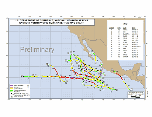
SUMMARY TABLE

NAME                DATES         MAX WIND (MPH)
---------------------------------------------------
TS ALETTA*         14-19 MAY           50
MH BUD             21-26 MAY          115
H  CARLOTTA        14-16 JUN          105
MH DANIEL           4-12 JUL          115
MH EMILIA           7-15 JUL          140
H  FABIO           12-18 JUL          105
H  GILMA            7-11 AUG           80
TS HECTOR          11-17 AUG           50
H  ILEANA       27 AUG-2 SEP           85
TS JOHN              2-4 SEP           40 
TS KRISTY          12-17 SEP           60 
H  LANE            15-19 SEP           80
MH MIRIAM          22-27 SEP          120
TS NORMAN          28-29 SEP           45
---------------------------------------------------      

* DENOTES A STORM FOR WHICH THE POST-STORM ANALYSIS IS COMPLETE.

$$
HURRICANE SPECIALIST UNIT


Preliminary Eastern North Pacific Tropical Cyclone Tracks


Quick Navigation Links:
Tropical Cyclone Forecasts  -  Tropical Marine Forecasts  -  Data Archive
Outreach  -  Prepare  -  About Cyclones  -  About NHC  -  Contact Us

NOAA/ National Weather Service
National Centers for Environmental Prediction
National Hurricane Center
11691 SW 17th Street
Miami, Florida 33165-2149 USA
nhcwebmaster@noaa.gov
Disclaimer
Credits
Information Quality
Glossary
Privacy Policy
Freedom of Information Act (FOIA)
About Us
Career Opportunities
Page last modified: Tuesday, 02-Oct-2012 02:40:14 UTC