
American Community Survey
Census.gov › American Community Survey › Guidance for Data Users: Geography and the American Community Survey
Geography and the American Community Survey
 Connect with us
Geography plays an important role in Census Bureau activities, including supporting the American Community Survey. It is the framework by which the Census Bureau collects and publishes demographic, social, housing, and economic data. Geography contributes to, and is involved in, ACS sampling, data collection, weighting, and data tabulation activities.
Key concepts to aid in your understanding include:
Geographic Areas
The nation is subdivided into two main types of geographic areas, legal and statistical.
Legal areas are defined specifically by law, and include state, local and tribal government units, as well as some specially defined administrative areas like congressional districts. Many, but not all, are represented by elected officials.
Example: New York State
Statistical areas are defined directly by the Census Bureau and state, regional or local authorities, and include census tracts and urban areas. The primary purpose of statistical areas is to tabulate and present census data.
Example: Metropolitan Statistical area - "Boston-Cambridge-Quincy-MA-NH Metro area"
For more information on Geographic Areas download the Geographic Terms and Concepts document.
Geographic Hierarchy
Geographic areas are organized in a geographic hierarchy. Larger units, like states, include smaller units, like counties and census tracts. This structure is derived from the legal, administrative, or areal relationships of the entities.
Hierarchy of Select Geographic Entities in the American Community Survey
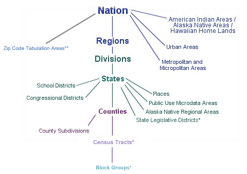
Notes:
* 5-year estimates only
** 5-year estimates only, first release in 2012 for the 2007-2011 5-year
estimates
This graphic does not represent the full set of
entities for which the ACS publishes data.
This geographic hierarchy influences how the Census Bureau identifies geographic areas. A system of geocodes - numeric or alphanumeric codes - are used to represent specific geographic areas.
Geographic Area Codes
The Census Bureau uses several different code sets to identify geographic areas depending on area type and purpose. The most frequently used code systems are FIPS and ANSI. The Census Bureau is moving towards implementing the ANSI code standard for most legal geographic areas.
FIPS = Federal Information Processing Standard
ANSI = American National Standards Institute
The Census Bureau's Geography Division provides additional information on the transition from FIPS to ANSI. ANSI codes are not currently used as geographic identifiers for ACS estimates.
To identify a geographic area in larger contexts like the nation, one or more higher level geocodes may be required. Census tracts are unique within counties and counties are unique within states. You need the full set of state, county, and tract geocodes to uniquely identify a census tract.
Example:
The unique geocode for the census tract 201 in Autauga County, Alabama is 01001020100.
| Name of Geography | State Code | County Code | Tract Code |
|---|---|---|---|
| Census Tract 201, Autauga County, Alabama | 01 | 001 | 020100 |
| Census Tract 201, La Paz County, Arizona | 04 | 012 | 020100 |
Geographic Change
Changes to geographic area definitions include boundary changes to legal and statistical areas, name changes, and geographic coding changes.
Boundary Changes for Legal Areas
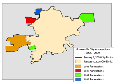
The Census Bureau annually conducts the Boundary and Annexation Survey (BAS) to collect information about selected legally defined geographic areas. Information provided through the BAS is used to update legal boundaries and names of governmental units in the United States. The boundary information collected through the BAS is used by the Census Bureau to tabulate data for censuses and a various surveys, including the American Community Survey. The ACS uses boundaries as of January 1 of the last year of the estimate period. For example, the 2006-2008 ACS 3-year uses boundaries as of January 1, 2008, as reported to the Census Bureau.
Example: Homerville City Annexations
Homerville City, a fictitious example, has annexed territory between 2005 and 2008 resulting in a boundary change. For the 2005-2009 ACS 5-year estimates, any survey responses collected from housing units in the annexed areas will be included in the Homerville City boundary because it is in the legal boundaries, as reported to the Census Bureau, on January 1, 2009.
Boundary Changes for Statistical Areas
Statistical areas also experience boundary changes, most often in association with each decennial census and much less frequently than legal areas as a whole do. Statistical areas are designed to have stable boundaries. There are several different statistical area definition programs associated with specific statistical area types. Two programs, the Participant Statistical Areas Program (PSAP) and the Tribal Statistical Areas Program (TSAP), address more familiar statistical areas like census tracts, block groups, Census Designated Places (CDPs) and tribal statistical areas.
Geographic Area Name and Code Changes
Occasionally a legal area will change its legal name, which also results in a change to the corresponding FIPS geographic code for the legal area. ANSI geographic codes are permanent and do not change with changes to the names of legal areas. For example, in 2006, Dover Township in Ocean County, NJ changed its name to Toms River Township. Its FIPS code changed from 18130 to 73125 in association with this name change, but its ANSI code remained 882074.
The American Community Survey does not update previously released estimates to reflect subsequent boundary changes.
Learn more about tools to help identify geographic and boundary changes for geographic areas.
Related Topics
Geography in Data and Documentation for topics specific to each Data Release
Additional Resources
Census Bureau Geography Division's website
Geographic Areas and Concepts for the American Community Survey in Training Presentations
[PDF] or ![]() denotes a file in Adobe’s Portable Document Format. To view the file, you will need the Adobe® Reader®
denotes a file in Adobe’s Portable Document Format. To view the file, you will need the Adobe® Reader® ![]() available free from Adobe.
This symbol
available free from Adobe.
This symbol ![]() indicates a link to a non-government web site. Our linking to these sites does not constitute an endorsement of any products, services or the information found on them. Once you link to another site you are subject to the policies of the new site.
indicates a link to a non-government web site. Our linking to these sites does not constitute an endorsement of any products, services or the information found on them. Once you link to another site you are subject to the policies of the new site.
 Current Data Profiles
Data by Topic
People
- Age and Sex / Aging
- Ancestry
- Disability
- Commuting to Work
- Education
- Employment
- Family/Relationships
- Health Insurance
- Income and Earnings
- Language
- Origins
- Population Change
- Poverty
- Race and Ethnicity
- Veterans
Housing
 Contact
 Call Us
- General 1-800-923-8282
- Questionnaire 1-800-354-7271
- ¿Ayuda? 1-877-833-5625
 Facebook
 Twitter
 Flickr
 YouTube