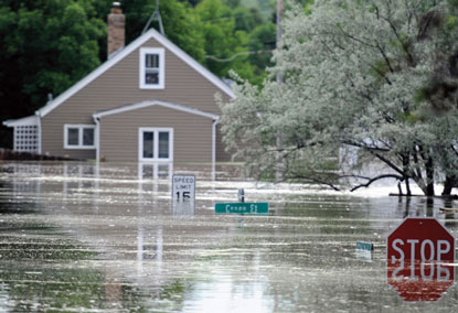
A long, tall slap of water
Ronald A. Wirtz - Editor, fedgazette
Published October 14, 2011 | October 2011 issue
The breadth of flooding is only one of its noteworthy dimensions. Just as remarkable is its collective depth and duration.
Many rivers and streams overtop their natural holding pens in spring, or during heavy rains, and some flooding in the district was of such garden variety. But most rivers and streams didn’t flood just a little. In district states, 18 rivers or tributaries rose at least five feet above flood stage at more than 40 locations (and given data limitations, there were likely more). In many of these rivers, flood stage is between 8 and 15 feet of river height, which means many sloshed easily and widely over their natural borders. The Wild Rice River near Abercrombie, N.D., shot past its flood stage of 10 feet to peak near 26 feet.
Souris River Floodwater in Bulrington, N.D.
In fact, depending on location, it doesn’t take a big rise in river level to cause serious consequences. “Depending on how flat the topography is, even one foot above flood stage can inundate a lot of land,” said Ryan Thompson, a hydrologist with the South Dakota office of the U.S. Geological Survey. For example, “the James River basin is very flat along most of its length, so small rises above flood stage can submerge a lot of agricultural land.”
This year the James’ rise was not small. The river also known as “the Jimmy” runs the vertical length of South Dakota, and USGS markers in eight locations across the state showed that the river rose between 5.8 feet and 11 feet over flood stage—a level sufficient to swamp thousands of acres of farmland. The basin’s flat topography also means that the water meanders, in no hurry to go anywhere—one reason that seven of these eight locations had been flooded for 120 days at the beginning of August.
Indeed, maybe more than any other characteristic, the floods of 2011 will be remembered—water-tortured into local memory—for their longevity; they lasted weeks in many places (see chart). “People expected the flood to exit quickly. This is a different breed; it’s much longer going away,” said Bill Wocken, Bismarck, N.D., city administrator.

More like the Big Meanie
It’s hard to say just how much dry land, how many homes, how much community got swallowed by floods in the district because existing data systems don’t track inundation (though new satellite and other technology may change that, at least for future floods). But other measures such as a river’s discharge—how much water is passing by at a given moment—help to illustrate the sheer volume of water involved in this year’s flooding.
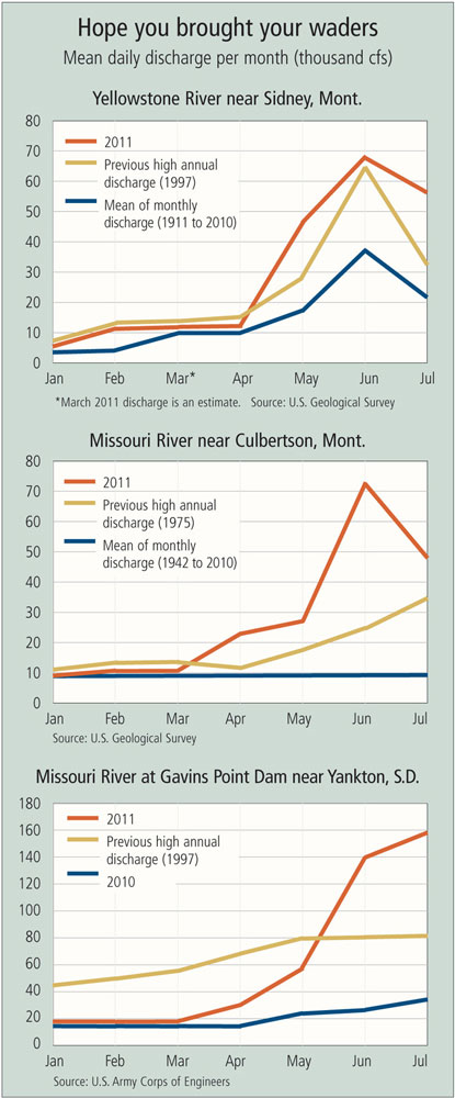
USGS data show that the 2011 floods have obliterated flow records in many rivers and streams. Twice in the span of about two weeks, the Musselshell River flooded the city of Roundup, Mont. The first onslaught came suddenly, in the middle of the night on May 26. Average flow for that time of year, according to USGS data, is about 600 cubic feet (or about 4,500 gallons) per second. The previous week, the Musselshell’s water levels were elevated and rising, and by the morning of May 25, water was whistling by at about 3,500 cfs.
Turns out that the Musselshell was just getting warmed up. By the end of the next day, it would briefly touch 15,000 cfs. Flood stage is 10 feet; the river roared to almost 15 feet, close to 2 feet higher than the previous mark set in 1975. A week later, the water finally fell below flood stage, only to quickly swell again on June 8, topping 14 feet for a repeat dousing of Roundup. The river didn’t fall below flood stage again until June 18.
Dozens of other small watercourses in the district have a similar story, and most of them eventually pour into the Missouri River (see map). The results were predictable. This summer, the Big Muddy reached levels not seen since the Pick-Sloan Act slung a harness on the river back in the 1940s. The law authorized and paid for the U.S. Army Corps of Engineers to install five additional dams (one in North Dakota, four in South Dakota) to go along with the Fort Peck Dam in Montana. The dams created monstrous reservoirs that could hold water as needed while controlling downstream releases at each level. The six impoundment lakes—among the largest freshwater lakes in the country—can hold enough water to put the entire state of North Dakota about a foot and a half underwater.
Normally, the reservoirs have ample room to absorb spring rains and snowmelt, but this year’s runoff was unprecedented. The Army Corps measures total runoff into the Missouri River above Sioux City, Iowa, in acre feet (an acre of water 1 foot deep, or about 325,000 gallons). This past June, runoff in the region was 13.8 million acre feet (MAF), the single highest monthly runoff since recordkeeping started in 1898. This outpouring came on top of May runoff of 10.5 MAF, the third-highest monthly runoff ever recorded. In those two months, the Missouri basin absorbed as much water as it typically receives in an entire year.
So much water came, so quickly, that the Corps was forced to literally open the floodgates. The river’s six dams in the district were opened wide so that each discharged 150,000 to 165,000 cfs for much of the summer. Not only were these record flows—by far—for each individual dam, but each was releasing 50 percent more water than Niagara Falls on a high-flow day. At the Oahe Dam near Fort Pierre, S.D., normal summertime river flow is 24,000 cfs, according to Mayor Sam Tidball. “We got up to 160,000. That’s one hell of a difference.”
- Aaron Richins, research assistant, contributed data research to this article.