|
 ENERGY PROGRAM NEWSLETTER ENERGY PROGRAM NEWSLETTER
CONTACT
Romeo Flores
Rocky Mountains
303.236.7774
Gary Stricker
Rocky Mountains
303.236.7763
Peter Warwick
Gulf Coast
703.648.6469
Cynthia Rice
Environmental Considerations
303.236.1989

|
|
|
Coalbed Methane and Coal Stratigraphy Research
Methane (natural gas), while frequently developed with petroleum, also occurs in association with coal. Coalbed methane accounts for about 7.5 percent of U.S. natural gas production. Recent U.S. estimates (Rice, 1997) indicate more than 700 trillion cubic feet (TCF) of coalbed methane gas in place, with over 100 TCF economically recoverable--a five-year supply at present rates of consumption.
USGS is developing models to accurately assess potential U.S. coalbed methane resources. These models evaluate:
-
Controls on the occurrence and recoverability of coalbed methane, including geologic, geochemical, engineering, technological and economic factors.
- Resource development issues and environmental implications.
The abundant occurrence of coal resources (30 trillion tonnes) worldwide is prone to generate about 7.5 TCF of gas-in-place. USGS has on-going research and assessments of CBM provided through Technical Assistant Agreements in order to transfer information and technology.
Collaborative Projects:
Coal stratigraphic geospatial database and publications products for the Powder River Basin and Alaska
Cooperative Project with Department of Energy, National Energy Technology Laboratory and U.S. Geological Survey in the Powder River Basin and Alaska. Interagency Agreement (IA DE FE000008)
Goal: Update coal reserves using the most current data control, geographic information system (GIS) based programs, and online publications for the Powder River Basin and Alaska.
Tasks:
Powder River Basin
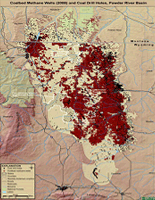
- Continue generating detailed digital GIS database of coalbed methane (CBM), coal, oil, and gas wells containing the Wyodak-Anderson coal beds mined in the Gillette coalfield and other coal beds/zones in the Fort Union and Wasatch Formations basinwide (Fig. 1)
- Generate GIS-based database containing coal-bed locations, stratigraphy, thickness, depth, and spatial information for over 18,500 wells in the PRB.
- Determine stratigraphic correlation and relationship of coal beds in the PRB with accompanying text, maps, and figures in order to improve depositional interpretations and understand distribution of coal beds basin-wide.
- Generate new basin-wide resource/reserve estimates to revise and improve the USGS 1999 National Coal Resource Assessment and determine demonstrated reserve base.
- New Publication: Revised Subsurface Stratigraphic Framework of the Fort Union and Wasatch Formations, Powder River Basin, Wyoming and Montana
Alaska
Generate digital databses that include coal geology/quality and stratigraphic data collected by the USGS, State of Alaska, and oil, gas, and coal Industry during the past few decades to improve, update and expand demonstrated reserve base for priority provinces:
- Northern Alaska-Slope Coal Province
- Southern Alaska-Cook Inlet Coal Provinc
More...
Powder River Basin Coalbed Methane Assessment
Cooperative Project with the U.S. Bureau of Land Management and U.S. Geological Survey in the Powder River Basin, Wyoming
The Bureau of Land Management (BLM) Wyoming Reservoir Management Group and the U.S. Geological Survey (USGS) began a cooperative project in 1999 to collect technical and analytical data on coalbed methane (CBM) resources and quality of the water produced from coalbeds in the Wyoming part of the Powder River Basin.
The agencies have complementary but divergent goals and these kinds of data are essential to accomplish their respective resource evaluation and management tasks. The project also addresses the general public need for information pertaining to Powder River Basin CBM resources and development.
More...
|
|
|
 RECENT PUBLICATIONS RECENT PUBLICATIONS
Geologic Cross Section, Gas Desorption, and Other Data From Four Wells Drilled for Alaska Rural Energy Project, Wainwright, Alaska, Coalbed Methane Project, 2007–2009
Revised Subsurface Stratigraphic Framework of the Fort Union and Wasatch Formations, Powder River Basin, Wyoming and Montana
RELATED LINKS
DOE Energy Information Administration (EIA) - Coalbed Methane Related Maps
Bureau of Land Management (BLM) Wyoming Energy Information
Petroleum Technology Transfer Council (Rocky Mountain Region - Colorado School of Mines)
Wyoming Oil and Gas Conservation Commission Energy Resources Website
USGS Publications Warehouse - Water quality and environmental isotopic analyses of ground-water samples collected from the Wasatch and Fort Union Formations in areas of coalbed methane development : implications to recharge and ground-water flow, eastern Powder River basin, Wyoming
More...
Top of Page
|
|

