Map
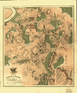
Atlas of the battlefield of Antietam, prepared under the direction of the Antietam Battlefield Board, lieut. col. Geo. W. Davis, U.S.A., president, gen. E.A. Carman, U.S.V., gen. H Heth, C.S.A. Surveyed by lieut. col. E.B. Cope, engineer, H.W. Mattern, assistant engineer, of the Gettysburg National Park. Drawn by Charles H. Ourand, 1899. Position of troops by gen. E. A. Carman. Published by authority of the Secretary of War, under the direction of the Chief of Engineers, U.S. Army, 1908.
Views

| Format |
Map |
|---|---|
| Contributors |
United States. War Dept |
| Dates |
1908 |
| Location |
Antietam Maryland United States |
| Language |
English |
| Subjects |
Antietam Antietam, Battle of Md. Maryland United States |
- Title
- Atlas of the battlefield of Antietam, prepared under the direction of the Antietam Battlefield Board, lieut. col. Geo. W. Davis, U.S.A., president, gen. E.A. Carman, U.S.V., gen. H Heth, C.S.A. Surveyed by lieut. col. E.B. Cope, engineer, H.W. Mattern, assistant engineer, of the Gettysburg National Park. Drawn by Charles H. Ourand, 1899. Position of troops by gen. E. A. Carman. Published by authority of the Secretary of War, under the direction of the Chief of Engineers, U.S. Army, 1908.
- Description
-
Relief shown by contour lines.
-
Indicates roads and streets, houses, names of residents, fences, vegetation, drainage, bridges, and fords.
-
Available also through the Library of Congress Web site as a raster image.
-
Phillips, 10685
-
LC Civil War maps (2nd ed.), 248
-
4 p. 1., 14 col. maps. 72 x 45 cm.
- Creator
- United States. War Dept.
- Created Published
-
[Washington, Govt. print. off.] 1908.
- Subject Headings
-
-
Antietam, Battle of MD., 1862
-
-
United States--Maryland--Antietam.
-
-
Antietam, Battle of MD.
- Notes
-
-
Relief shown by contour lines.
-
-
Indicates roads and streets, houses, names of residents, fences, vegetation, drainage, bridges, and fords.
-
-
Available also through the Library of Congress Web site as a raster image.
-
-
Phillips, 10685
-
-
LC Civil War maps (2nd ed.), 248
- Medium
-
4 p. 1., 14 col. maps. 72 x 45 cm.
- Call Number
-
G1272.A6S5 U5 1908
- Repository
-
Library of Congress Geography and Map Division Washington, D.C. 20540-4650 USA dcu
- Digital Id
-
g3842am gcw0248000 http://hdl.loc.gov/loc.gmd/g3842am.gcw0248000
- Library of Congress Catalog Number
- 2008621532
Rights & Access
The maps in the Map Collections materials were either published prior to 1922, produced by the United States government, or both (see catalogue records that accompany each map for information regarding date of publication and source). The Library of Congress is providing access to these materials for educational and research purposes and is not aware of any U.S. copyright protection (see Title 17 of the United States Code) or any other restrictions in the Map Collection materials.
Note that the written permission of the copyright owners and/or other rights holders (such as publicity and/or privacy rights) is required for distribution, reproduction, or other use of protected items beyond that allowed by fair use or other statutory exemptions. Responsibility for making an independent legal assessment of an item and securing any necessary permissions ultimately rests with persons desiring to use the item.
More about Copyright and other Restrictions
For guidance about compiling full citations consult Citing Primary Sources.
Part of...
-
Civil War Maps
[2281]
-
Military Battles And Campaigns Cartographic Items
[3867]
-
Geography And Maps Division
[60803]
-
American Memory
[1121009]
More maps like this
-
 Map of the battlefield of Antietam with the locations of monuments erected by the Commonwealth of Pennsylvania
Contributor:
Antietam Battlefield Memorial Commission
Site:
American Memory-cultural, Main Catalog
Original Format:
Map
Date:
1908
View catalog record
Map of the battlefield of Antietam with the locations of monuments erected by the Commonwealth of Pennsylvania
Contributor:
Antietam Battlefield Memorial Commission
Site:
American Memory-cultural, Main Catalog
Original Format:
Map
Date:
1908
View catalog record
-
 Antietam Battlefield : new 1972 /
Contributor:
United States. National Park Service
Site:
American Memory-cultural, Main Catalog
Original Format:
Map
Date:
1978
View catalog record
Antietam Battlefield : new 1972 /
Contributor:
United States. National Park Service
Site:
American Memory-cultural, Main Catalog
Original Format:
Map
Date:
1978
View catalog record
-
 Part of Maryland : showing the positions of the armies at 6 a.m. September 16, 1862 /
Contributor:
Geo. W. Stadly & Co
Site:
American Memory-cultural
Original Format:
Map
Date:
1898-01-01
Part of Maryland : showing the positions of the armies at 6 a.m. September 16, 1862 /
Contributor:
Geo. W. Stadly & Co
Site:
American Memory-cultural
Original Format:
Map
Date:
1898-01-01
-
 The field of Sharpsburg or of the Antietam : showing the positions of the armies at 3 p.m. on September 17, 1862 /
Contributor:
Geo. W. Stadly & Co
Site:
American Memory-cultural
Original Format:
Map
Date:
1898-01-01
The field of Sharpsburg or of the Antietam : showing the positions of the armies at 3 p.m. on September 17, 1862 /
Contributor:
Geo. W. Stadly & Co
Site:
American Memory-cultural
Original Format:
Map
Date:
1898-01-01
-
 Antietam Sharpsburg and vicinity. Constructed and engraved to illustrate "The war with the South"
Contributor:
Sholl, Charles
Site:
American Memory-cultural, Main Catalog
Original Format:
Map
Date:
1864
View catalog record
Antietam Sharpsburg and vicinity. Constructed and engraved to illustrate "The war with the South"
Contributor:
Sholl, Charles
Site:
American Memory-cultural, Main Catalog
Original Format:
Map
Date:
1864
View catalog record
-
 Antietam.
Contributor:
Michler, N.
Site:
American Memory-cultural, Main Catalog
Original Format:
Map
Date:
1867
View catalog record
Antietam.
Contributor:
Michler, N.
Site:
American Memory-cultural, Main Catalog
Original Format:
Map
Date:
1867
View catalog record
-
 Map of the battlefield of Antietam,
Contributor:
Willcox, William H.
Site:
American Memory-cultural, Main Catalog
Original Format:
Map
Date:
1862
View catalog record
Map of the battlefield of Antietam,
Contributor:
Willcox, William H.
Site:
American Memory-cultural, Main Catalog
Original Format:
Map
Date:
1862
View catalog record
-
 Map of the battlefield of Antietam
Contributor:
Antietam Battlefield Board
Site:
American Memory-cultural, Main Catalog
Original Format:
Map
Date:
1898
View catalog record
Map of the battlefield of Antietam
Contributor:
Antietam Battlefield Board
Site:
American Memory-cultural, Main Catalog
Original Format:
Map
Date:
1898
View catalog record
-
 Antietam. Enlarged and corrected from map of Gen. Michler, U.S. Eng.,
Contributor:
Gould, Oliver C.
Site:
American Memory-cultural, Main Catalog
Original Format:
Map
View catalog record
Antietam. Enlarged and corrected from map of Gen. Michler, U.S. Eng.,
Contributor:
Gould, Oliver C.
Site:
American Memory-cultural, Main Catalog
Original Format:
Map
View catalog record
-
 Atlas of the battlefield of Antietam /
Contributor:
Antietam Battlefield Board
Site:
American Memory-cultural, Main Catalog
Original Format:
Map
Date:
1904
View catalog record
Atlas of the battlefield of Antietam /
Contributor:
Antietam Battlefield Board
Site:
American Memory-cultural, Main Catalog
Original Format:
Map
Date:
1904
View catalog record
-
 Map of the battlefield of Antietam with the locations of monuments erected by the Commonwealth of Pennsylvania to the 3rd, 4th, 7th, 8th regiments of ...
Contributor:
Antietam Battlefield Memorial Commission
Site:
American Memory-cultural, Main Catalog
Original Format:
Map
Date:
1908
View catalog record
Map of the battlefield of Antietam with the locations of monuments erected by the Commonwealth of Pennsylvania to the 3rd, 4th, 7th, 8th regiments of ...
Contributor:
Antietam Battlefield Memorial Commission
Site:
American Memory-cultural, Main Catalog
Original Format:
Map
Date:
1908
View catalog record
-
 Antietam /
Contributor:
Michler, N.
Site:
American Memory-cultural, Main Catalog
Original Format:
Map
Date:
1867
View catalog record
Antietam /
Contributor:
Michler, N.
Site:
American Memory-cultural, Main Catalog
Original Format:
Map
Date:
1867
View catalog record
-
 [Map of the battlefield of Antietam
Contributor:
Antietam Battlefield Board
Site:
American Memory-cultural, Main Catalog
Original Format:
Map
Date:
1898
View catalog record
[Map of the battlefield of Antietam
Contributor:
Antietam Battlefield Board
Site:
American Memory-cultural, Main Catalog
Original Format:
Map
Date:
1898
View catalog record
-
 Map of the battlefield of Antietam. This map shows the position of each of the forty-two different commands of the regular army engaged in the ...
Contributor:
Antietam Battlefield Board
Site:
American Memory-cultural, Main Catalog
Original Format:
Map
Date:
1893-01-01
View catalog record
Map of the battlefield of Antietam. This map shows the position of each of the forty-two different commands of the regular army engaged in the ...
Contributor:
Antietam Battlefield Board
Site:
American Memory-cultural, Main Catalog
Original Format:
Map
Date:
1893-01-01
View catalog record
-
 Map of the battlefield of Antietam, [Sept. 17, 1862]
Contributor:
Willcox, William H.
Site:
American Memory-cultural, Main Catalog
Original Format:
Map
Date:
1862
View catalog record
Map of the battlefield of Antietam, [Sept. 17, 1862]
Contributor:
Willcox, William H.
Site:
American Memory-cultural, Main Catalog
Original Format:
Map
Date:
1862
View catalog record
You might also like
-
 Antietam Bridge, on Sharpsburgh and Boonsboro Turnkpike
Contributor:
Gardner, Alexander
Site:
Prints & Photographs, Main Catalog
Original Format:
Photo, Print, Drawing
Date:
1862
View catalog record
Antietam Bridge, on Sharpsburgh and Boonsboro Turnkpike
Contributor:
Gardner, Alexander
Site:
Prints & Photographs, Main Catalog
Original Format:
Photo, Print, Drawing
Date:
1862
View catalog record
-
 Antietam bridge, Maryland
Contributor:
Gardner, Alexander
Site:
Prints & Photographs, Main Catalog
Original Format:
Photo, Print, Drawing
Date:
1862
View catalog record
Antietam bridge, Maryland
Contributor:
Gardner, Alexander
Site:
Prints & Photographs, Main Catalog
Original Format:
Photo, Print, Drawing
Date:
1862
View catalog record
-
 The "Sunken Road" at Antietam
Contributor:
Gardner, Alexander
Site:
Prints & Photographs, Main Catalog
Original Format:
Photo, Print, Drawing
Date:
1862
View catalog record
The "Sunken Road" at Antietam
Contributor:
Gardner, Alexander
Site:
Prints & Photographs, Main Catalog
Original Format:
Photo, Print, Drawing
Date:
1862
View catalog record
-
 Bridge on the Boonsboro Pike, Antietam, Md.
Contributor:
Gardner, Alexander
Site:
Prints & Photographs, Main Catalog
Original Format:
Photo, Print, Drawing
Date:
1862
View catalog record
Bridge on the Boonsboro Pike, Antietam, Md.
Contributor:
Gardner, Alexander
Site:
Prints & Photographs, Main Catalog
Original Format:
Photo, Print, Drawing
Date:
1862
View catalog record
-
 Dunkers (i.e. Dunker) Church, battle field of Antietam. After battle, how dead were laid out
Contributor:
Gardner, Alexander
Site:
Prints & Photographs, Main Catalog
Original Format:
Photo, Print, Drawing
Date:
1862
View catalog record
Dunkers (i.e. Dunker) Church, battle field of Antietam. After battle, how dead were laid out
Contributor:
Gardner, Alexander
Site:
Prints & Photographs, Main Catalog
Original Format:
Photo, Print, Drawing
Date:
1862
View catalog record
-
 Where Sumner's Corps charged at Antietam
Contributor:
Gardner, Alexander
Site:
Prints & Photographs, Main Catalog
Original Format:
Photo, Print, Drawing
Date:
1862
View catalog record
Where Sumner's Corps charged at Antietam
Contributor:
Gardner, Alexander
Site:
Prints & Photographs, Main Catalog
Original Format:
Photo, Print, Drawing
Date:
1862
View catalog record