Map
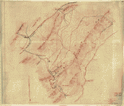
[Map of Royal Land Company of Virginia lands in Rockingham, and Augusta counties Virginia, and Pendleton County, West Virginia] /

| Format |
Map |
|---|---|
| Contributors |
Oltmanns, C. W. |
| Dates |
1877 |
| Location |
Augusta County Pendleton County Rockingham County United States Virginia West Virginia |
| Language |
English |
| Subjects |
Augusta County Augusta County (Va.) Pendleton County Pendleton County (W. Va.) Real Property Rockingham County Rockingham County (Va.) Royal Land Company United States Virginia West Virginia |
- Title
- [Map of Royal Land Company of Virginia lands in Rockingham, and Augusta counties Virginia, and Pendleton County, West Virginia] /
- Description
-
Title, date, and scale from Stephenson's Civil War maps, 1989.
-
Pen-and-ink, watercolor, and pencil over pencil grid on 3 sheets pasted together sectioned in 2, and mounted on cloth.
-
LC Civil War maps (2nd ed.), H269
-
Available also through the Library of Congress web site as raster image.
-
In pencil on verso: 330 crossed out.
-
1 ms. map : col. ; 104 x 44 cm.
- Creator
- Oltmanns, C. W.
- Subject Headings
-
-
Royal Land Company
-
-
Real property--Virginia--Rockingham County
-
-
Real property--Virginia--Augusta County
-
-
Real property--West Virginia--Pendleton County
-
-
Rockingham County (Va.)
-
-
Augusta County (Va.)
-
-
Pendleton County (W. Va.)
-
-
United States--Virginia--Rockingham County.
-
-
United States--Virginia--Augusta County.
-
-
United States--West Virginia--Pendleton County.
- Notes
-
-
Title, date, and scale from Stephenson's Civil War maps, 1989.
-
-
Pen-and-ink, watercolor, and pencil over pencil grid on 3 sheets pasted together sectioned in 2, and mounted on cloth.
-
-
LC Civil War maps (2nd ed.), H269
-
-
Available also through the Library of Congress web site as raster image.
-
-
In pencil on verso: 330 crossed out.
- Medium
-
1 ms. map : col. ; 104 x 44 cm.
- Call Number
-
G3883.R7G46 1877 .O4
- Repository
-
Library of Congress Geography and Map Division Washington, D.C. 20540-4650 dcu
- Digital Id
-
g3883r cwh00269 http://hdl.loc.gov/loc.gmd/g3883r.cwh00269
- Library of Congress Catalog Number
- 2005625172
Rights & Access
The maps in the Map Collections materials were either published prior to 1922, produced by the United States government, or both (see catalogue records that accompany each map for information regarding date of publication and source). The Library of Congress is providing access to these materials for educational and research purposes and is not aware of any U.S. copyright protection (see Title 17 of the United States Code) or any other restrictions in the Map Collection materials.
Note that the written permission of the copyright owners and/or other rights holders (such as publicity and/or privacy rights) is required for distribution, reproduction, or other use of protected items beyond that allowed by fair use or other statutory exemptions. Responsibility for making an independent legal assessment of an item and securing any necessary permissions ultimately rests with persons desiring to use the item.
More about Copyright and other Restrictions
For guidance about compiling full citations consult Citing Primary Sources.
Part of...
-
Hotchkiss Map Collection
[345]
-
Military Battles And Campaigns Cartographic Items
[3867]
-
Geography And Maps Division
[60803]
-
American Memory
[1121009]
More maps like this
-
 Copy Septr. 1879 (G.R.F) of map /
Contributor:
Oltmanns, C. W.
Site:
American Memory-cultural, Main Catalog
Original Format:
Map
Date:
1872
View catalog record
Copy Septr. 1879 (G.R.F) of map /
Contributor:
Oltmanns, C. W.
Site:
American Memory-cultural, Main Catalog
Original Format:
Map
Date:
1872
View catalog record
-
 [Sketch of parts of Highland County, Va., and Pendleton County, W. Va.].
Site:
American Memory-cultural, Main Catalog
Original Format:
Map
Date:
1861
View catalog record
[Sketch of parts of Highland County, Va., and Pendleton County, W. Va.].
Site:
American Memory-cultural, Main Catalog
Original Format:
Map
Date:
1861
View catalog record
-
 [Map of parts of Highland County, Va., and Pendleton County, W. Va.].
Site:
American Memory-cultural, Main Catalog
Original Format:
Map
Date:
1861
View catalog record
[Map of parts of Highland County, Va., and Pendleton County, W. Va.].
Site:
American Memory-cultural, Main Catalog
Original Format:
Map
Date:
1861
View catalog record
-
 [Sketch of roads and streams in Highland County, Va., and Pendleton County, W. Va.].
Site:
American Memory-cultural, Main Catalog
Original Format:
Map
Date:
1861
View catalog record
[Sketch of roads and streams in Highland County, Va., and Pendleton County, W. Va.].
Site:
American Memory-cultural, Main Catalog
Original Format:
Map
Date:
1861
View catalog record
-
 A topographical map of the Elizabeth Furnace iron property, Augusta Co., Va., containing about 6250 acres, Aug. 1867.
Contributor:
Hotchkiss, Jedediah
Site:
American Memory-cultural, Main Catalog
Original Format:
Map
Date:
1867
View catalog record
A topographical map of the Elizabeth Furnace iron property, Augusta Co., Va., containing about 6250 acres, Aug. 1867.
Contributor:
Hotchkiss, Jedediah
Site:
American Memory-cultural, Main Catalog
Original Format:
Map
Date:
1867
View catalog record
-
 Map of Dr. Dellinger's mill property with 153 acres of land showing proposed changes of public roads, bridge site &c. /
Contributor:
Hotchkiss, Jedediah
Site:
American Memory-cultural, Main Catalog
Original Format:
Map
Date:
1867
View catalog record
Map of Dr. Dellinger's mill property with 153 acres of land showing proposed changes of public roads, bridge site &c. /
Contributor:
Hotchkiss, Jedediah
Site:
American Memory-cultural, Main Catalog
Original Format:
Map
Date:
1867
View catalog record
-
 Colonial land patents and grantees : Calfpasture Rivers, Augusta County, Virginia /
Contributor:
Leitch, Meredith
Site:
American Memory-cultural
Original Format:
Map
Date:
1947
Colonial land patents and grantees : Calfpasture Rivers, Augusta County, Virginia /
Contributor:
Leitch, Meredith
Site:
American Memory-cultural
Original Format:
Map
Date:
1947
-
 [Sketch of the road from Waynesboro toward Staunton, in Augusta County, Virginia.].
Contributor:
Hotchkiss, Jedediah
Site:
American Memory-cultural, Main Catalog
Original Format:
Map
View catalog record
[Sketch of the road from Waynesboro toward Staunton, in Augusta County, Virginia.].
Contributor:
Hotchkiss, Jedediah
Site:
American Memory-cultural, Main Catalog
Original Format:
Map
View catalog record
-
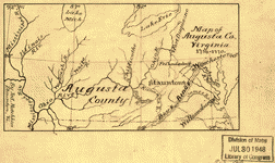 Map of Augusta Co., Virginia, 1738-1770
Contributor:
Hotchkiss, Jedediah
Site:
American Memory-cultural, Main Catalog
Original Format:
Map
Date:
1886
View catalog record
Map of Augusta Co., Virginia, 1738-1770
Contributor:
Hotchkiss, Jedediah
Site:
American Memory-cultural, Main Catalog
Original Format:
Map
Date:
1886
View catalog record
-
 [Part of Augusta County, Va.].
Contributor:
Hotchkiss, Jedediah
Site:
American Memory-cultural, Main Catalog
Original Format:
Map
View catalog record
[Part of Augusta County, Va.].
Contributor:
Hotchkiss, Jedediah
Site:
American Memory-cultural, Main Catalog
Original Format:
Map
View catalog record
-
 Augusta County, Virginia,
Contributor:
Hotchkiss, Jedediah
Site:
American Memory-cultural, Main Catalog
Original Format:
Map
Date:
1867
View catalog record
Augusta County, Virginia,
Contributor:
Hotchkiss, Jedediah
Site:
American Memory-cultural, Main Catalog
Original Format:
Map
Date:
1867
View catalog record
-
 Map of Augusta County, Virginia, 1886
Contributor:
Hotchkiss, Jedediah
Site:
American Memory-cultural, Main Catalog
Original Format:
Map
Date:
1886
View catalog record
Map of Augusta County, Virginia, 1886
Contributor:
Hotchkiss, Jedediah
Site:
American Memory-cultural, Main Catalog
Original Format:
Map
Date:
1886
View catalog record
-
 Map showing the location of Mount Rogers, Augusta Co., Va. /
Contributor:
Hotchkiss, Jedediah
Site:
American Memory-cultural, Main Catalog
Original Format:
Map
Date:
1886
View catalog record
Map showing the location of Mount Rogers, Augusta Co., Va. /
Contributor:
Hotchkiss, Jedediah
Site:
American Memory-cultural, Main Catalog
Original Format:
Map
Date:
1886
View catalog record
-
 Map of part of Augusta County, Colony of Virginia, 1755-1760
Contributor:
Hotchkiss, Jedediah
Site:
American Memory-cultural, Main Catalog
Original Format:
Map
Date:
1886
View catalog record
Map of part of Augusta County, Colony of Virginia, 1755-1760
Contributor:
Hotchkiss, Jedediah
Site:
American Memory-cultural, Main Catalog
Original Format:
Map
Date:
1886
View catalog record
-
 Geological section of Great and Little No. Mountains near Ferrol, Va. /
Contributor:
Campbell, J. L.
Site:
American Memory-cultural, Main Catalog
Original Format:
Map
View catalog record
Geological section of Great and Little No. Mountains near Ferrol, Va. /
Contributor:
Campbell, J. L.
Site:
American Memory-cultural, Main Catalog
Original Format:
Map
View catalog record
-
 Map of Augusta County, Virginia /
Contributor:
Hotchkiss, Jedediah
Site:
American Memory-cultural, Main Catalog
Original Format:
Map
Date:
1870
View catalog record
Map of Augusta County, Virginia /
Contributor:
Hotchkiss, Jedediah
Site:
American Memory-cultural, Main Catalog
Original Format:
Map
Date:
1870
View catalog record
You might also like
-

 Augusta County, Virginia, in the history of the United States,
Contributor:
Dunlap, Boutwell
Site:
Main Catalog
Original Format:
Book
Date:
1918
Augusta County, Virginia, in the history of the United States,
Contributor:
Dunlap, Boutwell
Site:
Main Catalog
Original Format:
Book
Date:
1918
-
Mercury loads in the South River and simulation of mercury total maximum daily loads (TMDLs) for the South River, South Fork Shenandoah River, and Shenandoah ...
Contributor:
Eggleston, Jack R.
Site:
Main Catalog
Original Format:
Book
Date:
2009
-
 A narrative of the leading incidents of the organization of the first popular movement in Virginia in 1865 to re-establish peaceful relations between the northern ...
Contributor:
Stuart, Alexander H. H.
Site:
American Memory-cultural, Main Catalog
Original Format:
Book
Date:
1888
View catalog record
A narrative of the leading incidents of the organization of the first popular movement in Virginia in 1865 to re-establish peaceful relations between the northern ...
Contributor:
Stuart, Alexander H. H.
Site:
American Memory-cultural, Main Catalog
Original Format:
Book
Date:
1888
View catalog record
-
Annals of Augusta County, Virginia,
Contributor:
Waddell, Joseph Addison
Site:
Main Catalog
Original Format:
Book
Date:
1886
-
A history of Rockingham County, Virginia /
Contributor:
Wayland, John Walter
Site:
Main Catalog
Original Format:
Book
Date:
1912
-
The valley of the shadow two communities in the American Civil War.
Site:
Main Catalog
Original Format:
Book
Date:
2004