Map
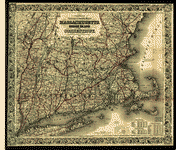
Telegraph and Rail Road map of the New England States.

| Format |
Map |
|---|---|
| Contributors |
Williams, Alexander |
| Dates |
1854 |
| Location |
New England United States |
| Language |
English |
| Subjects |
New England Railroads Telegraph Lines United States |
- Title
- Telegraph and Rail Road map of the New England States.
- Description
-
Scale ca. 1:775,000.
-
LC also has 1855 edition.
-
LC Railroad maps, 109
-
Description derived from published bibliography.
-
Inset: Map of Boston showing the entrance of the Rail Roads. Circle, diameter 22 cm.
-
Available also through the Library of Congress Web site as a raster image.
-
col. map 78 x 82 cm.
- Creator
- Williams, Alexander.
- Created Published
-
Boston, 1854.
- Subject Headings
-
-
Railroads--New England
-
-
Telegraph lines--New England
-
-
United States--New England.
- Notes
-
-
Scale ca. 1:775,000.
-
-
LC also has 1855 edition.
-
-
LC Railroad maps, 109
-
-
Description derived from published bibliography.
-
-
Inset: Map of Boston showing the entrance of the Rail Roads. Circle, diameter 22 cm.
-
-
Available also through the Library of Congress Web site as a raster image.
- Medium
-
col. map 78 x 82 cm.
- Call Number
-
G3721.P3 1854 .W5
- Repository
-
Library of Congress Geography and Map Division Washington, D.C. 20540-4650 USA dcu
- Digital Id
-
g3721p rr001090 http://hdl.loc.gov/loc.gmd/g3721p.rr001090
- Library of Congress Catalog Number
- 98688383
Rights & Access
The maps in the Map Collections materials were either published prior to 1922, produced by the United States government, or both (see catalogue records that accompany each map for information regarding date of publication and source). The Library of Congress is providing access to these materials for educational and research purposes and is not aware of any U.S. copyright protection (see Title 17 of the United States Code) or any other restrictions in the Map Collection materials.
Note that the written permission of the copyright owners and/or other rights holders (such as publicity and/or privacy rights) is required for distribution, reproduction, or other use of protected items beyond that allowed by fair use or other statutory exemptions. Responsibility for making an independent legal assessment of an item and securing any necessary permissions ultimately rests with persons desiring to use the item.
More about Copyright and other Restrictions
For guidance about compiling full citations consult Citing Primary Sources.
Part of...
-
Railroad Maps, 1828 1900
[617]
-
Transportation And Communication Cartographic Items
[761]
-
Geography And Maps Division
[60803]
-
American Memory
[1120991]
More maps like this
-
 Lloyd's railroad, telegraph & express map of the United States and Canadas from official information.
Contributor:
Lloyd, James T.
Site:
American Memory-cultural, Main Catalog
Original Format:
Map
Date:
1867
View catalog record
Lloyd's railroad, telegraph & express map of the United States and Canadas from official information.
Contributor:
Lloyd, James T.
Site:
American Memory-cultural, Main Catalog
Original Format:
Map
Date:
1867
View catalog record
-
 Complete map of the rail roads and water courses in the United Staes & Canada.
Contributor:
Charles Magnus & Co
Site:
American Memory-cultural, Main Catalog
Original Format:
Map
Date:
1859
View catalog record
Complete map of the rail roads and water courses in the United Staes & Canada.
Contributor:
Charles Magnus & Co
Site:
American Memory-cultural, Main Catalog
Original Format:
Map
Date:
1859
View catalog record
-
 Map of the Boston & Lowell R.R. system with its principal connections.
Contributor:
Rand Avery Supply Co
Site:
American Memory-cultural, Main Catalog
Original Format:
Map
Date:
1890
View catalog record
Map of the Boston & Lowell R.R. system with its principal connections.
Contributor:
Rand Avery Supply Co
Site:
American Memory-cultural, Main Catalog
Original Format:
Map
Date:
1890
View catalog record
-
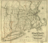
 Colton's railroad & township map of Massachusetts, Rhode Island, and Connecticut.
Contributor:
Colton, J. H.
Site:
American Memory-cultural, Main Catalog
Original Format:
Map
Date:
1853
View catalog record
Colton's railroad & township map of Massachusetts, Rhode Island, and Connecticut.
Contributor:
Colton, J. H.
Site:
American Memory-cultural, Main Catalog
Original Format:
Map
Date:
1853
View catalog record
-
 Ensign, Bridgman & Fanning's rail road map of the Eastern States.
Contributor:
Ensign, Bridgman & Fanning
Site:
American Memory-cultural, Main Catalog
Original Format:
Map
Date:
1856
View catalog record
Ensign, Bridgman & Fanning's rail road map of the Eastern States.
Contributor:
Ensign, Bridgman & Fanning
Site:
American Memory-cultural, Main Catalog
Original Format:
Map
Date:
1856
View catalog record
-
 J. Sage & Sons new & reliable rail road map, travellers edition, Eastern.
Contributor:
Sage (J.) & Sons
Site:
American Memory-cultural, Main Catalog
Original Format:
Map
Date:
1859
View catalog record
J. Sage & Sons new & reliable rail road map, travellers edition, Eastern.
Contributor:
Sage (J.) & Sons
Site:
American Memory-cultural, Main Catalog
Original Format:
Map
Date:
1859
View catalog record
-
 Map of railways in New England and part of New York; engraved by D. C. Hitchcock for the Pathfinder Railway Guide.
Contributor:
Snow & Wilder
Site:
American Memory-cultural, Main Catalog
Original Format:
Map
Date:
1847
View catalog record
Map of railways in New England and part of New York; engraved by D. C. Hitchcock for the Pathfinder Railway Guide.
Contributor:
Snow & Wilder
Site:
American Memory-cultural, Main Catalog
Original Format:
Map
Date:
1847
View catalog record
-
 Map showing the proposed rail roads from Boston to Burlington, from Hale's map of New England.
Contributor:
J.H. Bufford & Co
Site:
American Memory-cultural, Main Catalog
Original Format:
Map
Date:
1844
View catalog record
Map showing the proposed rail roads from Boston to Burlington, from Hale's map of New England.
Contributor:
J.H. Bufford & Co
Site:
American Memory-cultural, Main Catalog
Original Format:
Map
Date:
1844
View catalog record
-
 Map of railways in New England and part of New York; engraved by E. A. Teulon, expressly to accompany the Pathfinder Railway Guide.
Contributor:
George K. Snow & Co
Site:
American Memory-cultural, Main Catalog
Original Format:
Map
Date:
1849
View catalog record
Map of railways in New England and part of New York; engraved by E. A. Teulon, expressly to accompany the Pathfinder Railway Guide.
Contributor:
George K. Snow & Co
Site:
American Memory-cultural, Main Catalog
Original Format:
Map
Date:
1849
View catalog record
-
 Sketch of the states of Massachusetts, Connecticut, and Rhode Island, and parts of New Hampshire & New York exhibiting the several rail road routes completed, ...
Contributor:
Kennedy, Archibald
Site:
American Memory-cultural, Main Catalog
Original Format:
Map
Date:
1846
View catalog record
Sketch of the states of Massachusetts, Connecticut, and Rhode Island, and parts of New Hampshire & New York exhibiting the several rail road routes completed, ...
Contributor:
Kennedy, Archibald
Site:
American Memory-cultural, Main Catalog
Original Format:
Map
Date:
1846
View catalog record
-
 Boston & Maine Railroad and connections.
Contributor:
Rand McNally and Company
Site:
American Memory-cultural, Main Catalog
Original Format:
Map
Date:
1898
View catalog record
Boston & Maine Railroad and connections.
Contributor:
Rand McNally and Company
Site:
American Memory-cultural, Main Catalog
Original Format:
Map
Date:
1898
View catalog record
-
 Map of rail road routes from Rouse's Point to Portsmouth and Boston; compiled for the Cocheco Railroad Co. November, 1848.
Contributor:
Parrott, George B.
Site:
American Memory-cultural, Main Catalog
Original Format:
Map
Date:
1848
View catalog record
Map of rail road routes from Rouse's Point to Portsmouth and Boston; compiled for the Cocheco Railroad Co. November, 1848.
Contributor:
Parrott, George B.
Site:
American Memory-cultural, Main Catalog
Original Format:
Map
Date:
1848
View catalog record
-
 Colton's railroad & township map of New England with portions of the state of New York, the British provinces &c.
Contributor:
Colton, G. Woolworth
Site:
American Memory-cultural, Main Catalog
Original Format:
Map
Date:
1852
View catalog record
Colton's railroad & township map of New England with portions of the state of New York, the British provinces &c.
Contributor:
Colton, G. Woolworth
Site:
American Memory-cultural, Main Catalog
Original Format:
Map
Date:
1852
View catalog record
-
 Railroad map, showing the fact that about 65 miles of railroad to be constructed would form one of the principal railroad connections on this continent.
Contributor:
C. D. Andrews & Co
Site:
American Memory-cultural, Main Catalog
Original Format:
Map
Date:
1856
View catalog record
Railroad map, showing the fact that about 65 miles of railroad to be constructed would form one of the principal railroad connections on this continent.
Contributor:
C. D. Andrews & Co
Site:
American Memory-cultural, Main Catalog
Original Format:
Map
Date:
1856
View catalog record
-
 Map showing the line of the New Haven, Middletown, and Boston Railroad and its connections.
Contributor:
G.W. & C.B. Colton & Co
Site:
American Memory-cultural, Main Catalog
Original Format:
Map
Date:
1867
View catalog record
Map showing the line of the New Haven, Middletown, and Boston Railroad and its connections.
Contributor:
G.W. & C.B. Colton & Co
Site:
American Memory-cultural, Main Catalog
Original Format:
Map
Date:
1867
View catalog record
-
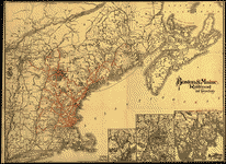
 Railroad map of New England & eastern New York complied from the most authentic sources.
Contributor:
Goldthwait, J. H.
Site:
American Memory-cultural, Main Catalog
Original Format:
Map
Date:
1849
View catalog record
Railroad map of New England & eastern New York complied from the most authentic sources.
Contributor:
Goldthwait, J. H.
Site:
American Memory-cultural, Main Catalog
Original Format:
Map
Date:
1849
View catalog record
You might also like
-
 Telegraph lineman. Location: Kentucky
Contributor:
Hine, Lewis Wickes
Site:
Prints & Photographs
Original Format:
Photo, Print, Drawing
Date:
1916
Telegraph lineman. Location: Kentucky
Contributor:
Hine, Lewis Wickes
Site:
Prints & Photographs
Original Format:
Photo, Print, Drawing
Date:
1916
-

 Reauthorization of the Magnuson-Stevens Fishery Conservation and Management Act : field hearing before the Subcommittee on Oceans and Fisheries of the Committee on Commerce, Science, ...
Contributor:
United States. Congress. Senate. Committee on Commerce, Science, and Transportation. Subcommittee on Oceans and Fisheries
Site:
Main Catalog
Original Format:
Book
Date:
1999-09-25
Reauthorization of the Magnuson-Stevens Fishery Conservation and Management Act : field hearing before the Subcommittee on Oceans and Fisheries of the Committee on Commerce, Science, ...
Contributor:
United States. Congress. Senate. Committee on Commerce, Science, and Transportation. Subcommittee on Oceans and Fisheries
Site:
Main Catalog
Original Format:
Book
Date:
1999-09-25
-
 Peaceful New England harbor
Contributor:
Highsmith, Carol M.
Site:
Prints & Photographs, Main Catalog
Original Format:
Photo, Print, Drawing
Date:
1980
View catalog record
Peaceful New England harbor
Contributor:
Highsmith, Carol M.
Site:
Prints & Photographs, Main Catalog
Original Format:
Photo, Print, Drawing
Date:
1980
View catalog record
-
 New England harbor and old wooden pier
Contributor:
Highsmith, Carol M.
Site:
Prints & Photographs, Main Catalog
Original Format:
Photo, Print, Drawing
Date:
1980
View catalog record
New England harbor and old wooden pier
Contributor:
Highsmith, Carol M.
Site:
Prints & Photographs, Main Catalog
Original Format:
Photo, Print, Drawing
Date:
1980
View catalog record
-
 New England harbor scene
Contributor:
Highsmith, Carol M.
Site:
Prints & Photographs, Main Catalog
Original Format:
Photo, Print, Drawing
Date:
1980
View catalog record
New England harbor scene
Contributor:
Highsmith, Carol M.
Site:
Prints & Photographs, Main Catalog
Original Format:
Photo, Print, Drawing
Date:
1980
View catalog record
-
Oldtown fireside stories /
Contributor:
Stowe, Harriet Beecher
Site:
Main Catalog
Original Format:
Book
Date:
1872