Map
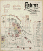
Sanborn Fire Insurance Map from Anderson, Madison County, Indiana.
Views

| Format |
Map |
|---|---|
| Dates |
1890 |
| Location |
Anderson Indiana Madison County |
| Language |
English |
- Title
- Sanborn Fire Insurance Map from Anderson, Madison County, Indiana.
- Description
-
12 Sheet(s). Mar 1890.
- Created Published
- Sanborn Map Company, Mar 1890
- Notes
-
-
12 Sheet(s).
-
-
Mar 1890.
- Repository
- Library of Congress Geography and Map Division Washington, D.C. 20540-4650 USA
- Digital Id
-
http://www.loc.gov/item/sanborn02251_002
-
http://hdl.loc.gov/loc.gmd/g4094am.02251002
Rights & Access
The maps in the Map Collections materials were either published prior to 1922, produced by the United States government, or both (see catalogue records that accompany each map for information regarding date of publication and source). The Library of Congress is providing access to these materials for educational and research purposes and is not aware of any U.S. copyright protection (see Title 17 of the United States Code) or any other restrictions in the Map Collection materials.
Note that the written permission of the copyright owners and/or other rights holders (such as publicity and/or privacy rights) is required for distribution, reproduction, or other use of protected items beyond that allowed by fair use or other statutory exemptions. Responsibility for making an independent legal assessment of an item and securing any necessary permissions ultimately rests with persons desiring to use the item.
More about Copyright and other Restrictions
For guidance about compiling full citations consult Citing Primary Sources.
Part of...
-
Sanborn Maps
[50014]
-
Geography And Maps Division
[60803]
-
American Memory
[1120991]
More maps like this
-
 Sanborn Fire Insurance Map from Anderson, Madison County, Indiana.
Site:
American Memory-cultural
Original Format:
Map
Date:
1886
Sanborn Fire Insurance Map from Anderson, Madison County, Indiana.
Site:
American Memory-cultural
Original Format:
Map
Date:
1886
-
 Sanborn Fire Insurance Map from Anderson, Madison County, Indiana.
Site:
American Memory-cultural
Original Format:
Map
Date:
1895-01-01
Sanborn Fire Insurance Map from Anderson, Madison County, Indiana.
Site:
American Memory-cultural
Original Format:
Map
Date:
1895-01-01
-
 Sanborn Fire Insurance Map from Alexandria, Madison County, Indiana.
Site:
American Memory-cultural
Original Format:
Map
Date:
1892-01-01
Sanborn Fire Insurance Map from Alexandria, Madison County, Indiana.
Site:
American Memory-cultural
Original Format:
Map
Date:
1892-01-01
-
 Sanborn Fire Insurance Map from Alexandria, Madison County, Indiana.
Site:
American Memory-cultural
Original Format:
Map
Date:
1896-01-01
Sanborn Fire Insurance Map from Alexandria, Madison County, Indiana.
Site:
American Memory-cultural
Original Format:
Map
Date:
1896-01-01
-
 Sanborn Fire Insurance Map from Alexandria, Madison County, Indiana.
Site:
American Memory-cultural
Original Format:
Map
Date:
1902-01-01
Sanborn Fire Insurance Map from Alexandria, Madison County, Indiana.
Site:
American Memory-cultural
Original Format:
Map
Date:
1902-01-01
-
 Sanborn Fire Insurance Map from Alexandria, Madison County, Indiana.
Site:
American Memory-cultural
Original Format:
Map
Date:
1909-01-01
Sanborn Fire Insurance Map from Alexandria, Madison County, Indiana.
Site:
American Memory-cultural
Original Format:
Map
Date:
1909-01-01
-
 Atlas of Madison County, Iowa /
Contributor:
Midland Map Company (Knoxville, Iowa)
Site:
American Memory-cultural, Main Catalog
Original Format:
Map
Date:
1912
View catalog record
Atlas of Madison County, Iowa /
Contributor:
Midland Map Company (Knoxville, Iowa)
Site:
American Memory-cultural, Main Catalog
Original Format:
Map
Date:
1912
View catalog record
-
 [Sketches of portions of Madison County, Va.].
Site:
American Memory-cultural, Main Catalog
Original Format:
Map
View catalog record
[Sketches of portions of Madison County, Va.].
Site:
American Memory-cultural, Main Catalog
Original Format:
Map
View catalog record
-
 Caldwell's atlas of Madison Co., Ohio /
Contributor:
Cring, Henry
Site:
American Memory-cultural, Main Catalog
Original Format:
Map
Date:
1875
View catalog record
Caldwell's atlas of Madison Co., Ohio /
Contributor:
Cring, Henry
Site:
American Memory-cultural, Main Catalog
Original Format:
Map
Date:
1875
View catalog record
-
 Map of Madison county, Alabama /
Contributor:
Mayhew, James H.
Site:
American Memory-cultural, Main Catalog
Original Format:
Map
Date:
1875
View catalog record
Map of Madison county, Alabama /
Contributor:
Mayhew, James H.
Site:
American Memory-cultural, Main Catalog
Original Format:
Map
Date:
1875
View catalog record
-
 [Map of Madison County, Va.].
Site:
American Memory-cultural, Main Catalog
Original Format:
Map
View catalog record
[Map of Madison County, Va.].
Site:
American Memory-cultural, Main Catalog
Original Format:
Map
View catalog record
-
 Survey of Culpeper and a part of Madison counties, Virginia /
Contributor:
Dwight, C. S.
Site:
American Memory-cultural, Main Catalog
Original Format:
Map
Date:
1863
View catalog record
Survey of Culpeper and a part of Madison counties, Virginia /
Contributor:
Dwight, C. S.
Site:
American Memory-cultural, Main Catalog
Original Format:
Map
Date:
1863
View catalog record
-
 Map of Madison County, Texas.
Contributor:
Texas. General Land Office
Site:
American Memory-cultural, Main Catalog
Original Format:
Map
Date:
1879
View catalog record
Map of Madison County, Texas.
Contributor:
Texas. General Land Office
Site:
American Memory-cultural, Main Catalog
Original Format:
Map
Date:
1879
View catalog record
-
-
 Standard atlas of Madison County, Illinois : including a plat book of the villages, cities and townships of the county, map of the state, United ...
Contributor:
Geo. A. Ogle & Co
Site:
American Memory-cultural, Main Catalog
Original Format:
Map
Date:
1906
View catalog record
Standard atlas of Madison County, Illinois : including a plat book of the villages, cities and townships of the county, map of the state, United ...
Contributor:
Geo. A. Ogle & Co
Site:
American Memory-cultural, Main Catalog
Original Format:
Map
Date:
1906
View catalog record
-
 [Sketch of the road from Madison northward to Dulaney's in Madison County, Va.].
Site:
American Memory-cultural, Main Catalog
Original Format:
Map
View catalog record
[Sketch of the road from Madison northward to Dulaney's in Madison County, Va.].
Site:
American Memory-cultural, Main Catalog
Original Format:
Map
View catalog record

You might also like
-
 Buckeye Manufacturing Company, Columbia Avenue, Anderson, Madison County, IN
Contributor:
Historic American Engineering Record, Lambert Brothers Manufacturing Company, Lambert, John William, Boucher, Jack E, Sackheim, Donald, Rosenberg, Robert
Site:
Prints & Photographs
Original Format:
Photo, Print, Drawing
Buckeye Manufacturing Company, Columbia Avenue, Anderson, Madison County, IN
Contributor:
Historic American Engineering Record, Lambert Brothers Manufacturing Company, Lambert, John William, Boucher, Jack E, Sackheim, Donald, Rosenberg, Robert
Site:
Prints & Photographs
Original Format:
Photo, Print, Drawing
-
 Speed Changing Pulley Company Factory, Thirty-second Street, Anderson, Madison County, IN
Contributor:
Historic American Engineering Record, DeTamble Motors Company, National Tile Company, DeTamble, Edward S, Zinke, Lewis, Boucher, Jack E, Sackheim, Donald, Rosenberg, Robert
Site:
Prints & Photographs
Original Format:
Photo, Print, Drawing
Speed Changing Pulley Company Factory, Thirty-second Street, Anderson, Madison County, IN
Contributor:
Historic American Engineering Record, DeTamble Motors Company, National Tile Company, DeTamble, Edward S, Zinke, Lewis, Boucher, Jack E, Sackheim, Donald, Rosenberg, Robert
Site:
Prints & Photographs
Original Format:
Photo, Print, Drawing
-
 Rider-Lewis Motor Car Company, West Second Street & Sycamore, Anderson, Madison County, IN
Contributor:
Historic American Engineering Record, DelaHunt, Thomas J, Nyberg, Henry, Boucher, Jack E, Rosenberg, Robert, Sackheim, Donald
Site:
Prints & Photographs
Original Format:
Photo, Print, Drawing
Rider-Lewis Motor Car Company, West Second Street & Sycamore, Anderson, Madison County, IN
Contributor:
Historic American Engineering Record, DelaHunt, Thomas J, Nyberg, Henry, Boucher, Jack E, Rosenberg, Robert, Sackheim, Donald
Site:
Prints & Photographs
Original Format:
Photo, Print, Drawing
-
 Anderson Carriage Manufacturing Company, Twenty-fifth & Walton Streets, Anderson, Madison County, IN
Contributor:
Historic American Engineering Record, Wheelock, George B, Boucher, Jack E
Site:
Prints & Photographs
Original Format:
Photo, Print, Drawing
Anderson Carriage Manufacturing Company, Twenty-fifth & Walton Streets, Anderson, Madison County, IN
Contributor:
Historic American Engineering Record, Wheelock, George B, Boucher, Jack E
Site:
Prints & Photographs
Original Format:
Photo, Print, Drawing
-
 Courthouse Square Row Buildings, Facade Study, Ninth Street, Anderson, Madison County, IN
Contributor:
Historic American Buildings Survey
Site:
Prints & Photographs
Original Format:
Photo, Print, Drawing
Courthouse Square Row Buildings, Facade Study, Ninth Street, Anderson, Madison County, IN
Contributor:
Historic American Buildings Survey
Site:
Prints & Photographs
Original Format:
Photo, Print, Drawing
-
1. GENERAL VIEW FROM SOUTHEAST OF EAST FACADE - Buckeye Manufacturing Company, Columbia Avenue, Anderson, Madison County, IN
Site:
Prints & Photographs
Original Format:
Photo, Print, Drawing