Map
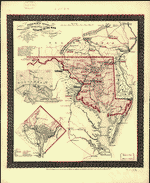
Sanborn Fire Insurance Map from Bel Air, Harford County, Maryland.
Views

| Format |
Map |
|---|---|
| Dates |
1921 |
| Location |
Bel Air Harford County Maryland |
| Language |
English |
- Title
- Sanborn Fire Insurance Map from Bel Air, Harford County, Maryland.
- Description
-
7 Sheet(s). May 1921.
- Created Published
- Sanborn Map Company, May 1921
- Notes
-
-
7 Sheet(s).
-
-
May 1921.
- Repository
- Library of Congress Geography and Map Division Washington, D.C. 20540-4650 USA
- Digital Id
-
http://www.loc.gov/item/sanborn03575_004
-
http://hdl.loc.gov/loc.gmd/g3844bm.g03575004
Rights & Access
The maps in the Map Collections materials were either published prior to 1922, produced by the United States government, or both (see catalogue records that accompany each map for information regarding date of publication and source). The Library of Congress is providing access to these materials for educational and research purposes and is not aware of any U.S. copyright protection (see Title 17 of the United States Code) or any other restrictions in the Map Collection materials.
Note that the written permission of the copyright owners and/or other rights holders (such as publicity and/or privacy rights) is required for distribution, reproduction, or other use of protected items beyond that allowed by fair use or other statutory exemptions. Responsibility for making an independent legal assessment of an item and securing any necessary permissions ultimately rests with persons desiring to use the item.
More about Copyright and other Restrictions
For guidance about compiling full citations consult Citing Primary Sources.
Part of...
-
Sanborn Maps
[50014]
-
Geography And Maps Division
[60803]
-
American Memory
[1120991]
More maps like this
-
 Sanborn Fire Insurance Map from Bel Air, Harford County, Maryland.
Site:
American Memory-cultural
Original Format:
Map
Date:
1897-01-01
Sanborn Fire Insurance Map from Bel Air, Harford County, Maryland.
Site:
American Memory-cultural
Original Format:
Map
Date:
1897-01-01
-
 Sanborn Fire Insurance Map from Bel Air, Harford County, Maryland.
Site:
American Memory-cultural
Original Format:
Map
Date:
1904-01-01
Sanborn Fire Insurance Map from Bel Air, Harford County, Maryland.
Site:
American Memory-cultural
Original Format:
Map
Date:
1904-01-01
-
 Sanborn Fire Insurance Map from Bel Air, Harford County, Maryland.
Site:
American Memory-cultural
Original Format:
Map
Date:
1910-01-01
Sanborn Fire Insurance Map from Bel Air, Harford County, Maryland.
Site:
American Memory-cultural
Original Format:
Map
Date:
1910-01-01
-
 Sanborn Fire Insurance Map from Aberdeen, Harford County, Maryland.
Site:
American Memory-cultural
Original Format:
Map
Date:
1904-01-01
Sanborn Fire Insurance Map from Aberdeen, Harford County, Maryland.
Site:
American Memory-cultural
Original Format:
Map
Date:
1904-01-01
-
 Sanborn Fire Insurance Map from Aberdeen, Harford County, Maryland.
Site:
American Memory-cultural
Original Format:
Map
Date:
1910-01-01
Sanborn Fire Insurance Map from Aberdeen, Harford County, Maryland.
Site:
American Memory-cultural
Original Format:
Map
Date:
1910-01-01
-
 Sanborn Fire Insurance Map from Aberdeen, Harford County, Maryland.
Site:
American Memory-cultural
Original Format:
Map
Date:
1916-01-01
Sanborn Fire Insurance Map from Aberdeen, Harford County, Maryland.
Site:
American Memory-cultural
Original Format:
Map
Date:
1916-01-01
-
 Sanborn Fire Insurance Map from Aberdeen, Harford County, Maryland.
Site:
American Memory-cultural
Original Format:
Map
Date:
1920-01-01
Sanborn Fire Insurance Map from Aberdeen, Harford County, Maryland.
Site:
American Memory-cultural
Original Format:
Map
Date:
1920-01-01
-
 A map of Harford Co., Maryland, 1858.
Contributor:
Herrick, L. W.
Site:
American Memory-cultural, Main Catalog
Original Format:
Map
Date:
1858
View catalog record
A map of Harford Co., Maryland, 1858.
Contributor:
Herrick, L. W.
Site:
American Memory-cultural, Main Catalog
Original Format:
Map
Date:
1858
View catalog record
-
 Martenet's Map of Harford County, Maryland : shore lines and tide water from U.S. Coast Survey, the county from actual surveys /
Contributor:
Martenet, Simon J.
Site:
American Memory-cultural, Main Catalog
Original Format:
Map
Date:
1878
View catalog record
Martenet's Map of Harford County, Maryland : shore lines and tide water from U.S. Coast Survey, the county from actual surveys /
Contributor:
Martenet, Simon J.
Site:
American Memory-cultural, Main Catalog
Original Format:
Map
Date:
1878
View catalog record
-
 Pocket map showing the probable theatre of the war
Contributor:
Aschbach, G. A.
Site:
American Memory-cultural, Main Catalog
Original Format:
Map
Date:
1861
View catalog record
Pocket map showing the probable theatre of the war
Contributor:
Aschbach, G. A.
Site:
American Memory-cultural, Main Catalog
Original Format:
Map
Date:
1861
View catalog record
-
 The State of Maryland from the best authorities.
Contributor:
Lewis, Samuel
Site:
American Memory-cultural, Main Catalog
Original Format:
Map
Date:
1795
View catalog record
The State of Maryland from the best authorities.
Contributor:
Lewis, Samuel
Site:
American Memory-cultural, Main Catalog
Original Format:
Map
Date:
1795
View catalog record
-
 Map of the country embracing the various routes surveyed for the Balt. & Ohio Rail Road by order of the Board of Engineers.
Contributor:
Barney, Joshua
Site:
American Memory-cultural, Main Catalog
Original Format:
Map
Date:
1831
View catalog record
Map of the country embracing the various routes surveyed for the Balt. & Ohio Rail Road by order of the Board of Engineers.
Contributor:
Barney, Joshua
Site:
American Memory-cultural, Main Catalog
Original Format:
Map
Date:
1831
View catalog record
-
 Thirty pen and ink maps of the Maryland Campaign, 1862 : drawn from descriptive readings and map fragments /
Contributor:
Russell, Robert E. L.
Site:
American Memory-cultural, Main Catalog
Original Format:
Map
Date:
1932
View catalog record
Thirty pen and ink maps of the Maryland Campaign, 1862 : drawn from descriptive readings and map fragments /
Contributor:
Russell, Robert E. L.
Site:
American Memory-cultural, Main Catalog
Original Format:
Map
Date:
1932
View catalog record
-
 Map showing the connection of the coal-field of Allegany with the canal and rail-road improvements of the Potomac.
Contributor:
Edward Weber & Co
Site:
American Memory-cultural, Main Catalog
Original Format:
Map
View catalog record
Map showing the connection of the coal-field of Allegany with the canal and rail-road improvements of the Potomac.
Contributor:
Edward Weber & Co
Site:
American Memory-cultural, Main Catalog
Original Format:
Map
View catalog record
-
 Map of the State of Maryland.
Contributor:
Lucas, Fielding
Site:
American Memory-cultural, Main Catalog
Original Format:
Map
Date:
1841
View catalog record
Map of the State of Maryland.
Contributor:
Lucas, Fielding
Site:
American Memory-cultural, Main Catalog
Original Format:
Map
Date:
1841
View catalog record
-
 Pocket map showing the probable theatre of the war
Contributor:
Aschbach, G. A.
Site:
American Memory-cultural, Main Catalog
Original Format:
Map
Date:
1861
View catalog record
Pocket map showing the probable theatre of the war
Contributor:
Aschbach, G. A.
Site:
American Memory-cultural, Main Catalog
Original Format:
Map
Date:
1861
View catalog record
You might also like
-
 Liriodendron, 502 West Gordon Street, Bel Air, Harford County, MD
Contributor:
Historic American Buildings Survey, Smalling, Walter
Site:
Prints & Photographs
Original Format:
Photo, Print, Drawing
Liriodendron, 502 West Gordon Street, Bel Air, Harford County, MD
Contributor:
Historic American Buildings Survey, Smalling, Walter
Site:
Prints & Photographs
Original Format:
Photo, Print, Drawing
-
 Liriodendron, Barn, 502 West Gordon Street, Bel Air, Harford County, MD
Contributor:
Historic American Buildings Survey, Smalling, Walter, Dolinsky, Paul, Cronenberger, Richard, Newdorfer, William L, Massengill, Rudy, Berry, Reginald, Shepherd, Les
Site:
Prints & Photographs
Original Format:
Photo, Print, Drawing
Liriodendron, Barn, 502 West Gordon Street, Bel Air, Harford County, MD
Contributor:
Historic American Buildings Survey, Smalling, Walter, Dolinsky, Paul, Cronenberger, Richard, Newdorfer, William L, Massengill, Rudy, Berry, Reginald, Shepherd, Les
Site:
Prints & Photographs
Original Format:
Photo, Print, Drawing
-
 Thomas Run House, Kalmia & Thomas Run Roads, Bel Air, Harford County, MD
Contributor:
Historic American Buildings Survey, Pickering, E H
Site:
Prints & Photographs
Original Format:
Photo, Print, Drawing
Thomas Run House, Kalmia & Thomas Run Roads, Bel Air, Harford County, MD
Contributor:
Historic American Buildings Survey, Pickering, E H
Site:
Prints & Photographs
Original Format:
Photo, Print, Drawing
-
 Harford National Bank, Bel Air, Harford County, MD
Contributor:
Historic American Buildings Survey, Harford County, Maryland Historical Trust, McKewin, Philip
Site:
Prints & Photographs
Original Format:
Photo, Print, Drawing
Harford National Bank, Bel Air, Harford County, MD
Contributor:
Historic American Buildings Survey, Harford County, Maryland Historical Trust, McKewin, Philip
Site:
Prints & Photographs
Original Format:
Photo, Print, Drawing
-
 Masonic Lodge, Wall Street, Bel Air, Harford County, MD
Contributor:
Historic American Buildings Survey, McKewin, Phillip W
Site:
Prints & Photographs
Original Format:
Photo, Print, Drawing
Masonic Lodge, Wall Street, Bel Air, Harford County, MD
Contributor:
Historic American Buildings Survey, McKewin, Phillip W
Site:
Prints & Photographs
Original Format:
Photo, Print, Drawing
-
 Dallam House, Wheel Road, Bel Air, Harford County, MD
Contributor:
Historic American Buildings Survey, Pickering, E H
Site:
Prints & Photographs
Original Format:
Photo, Print, Drawing
Dallam House, Wheel Road, Bel Air, Harford County, MD
Contributor:
Historic American Buildings Survey, Pickering, E H
Site:
Prints & Photographs
Original Format:
Photo, Print, Drawing