


![Plan général du Fort Septentrional du Detour des Anglois, tel qu'il est présentement : [Louisiana]](https://cybercemetery.unt.edu/archive/oilspill/20121109154608im_/http://www.loc.gov/collections/static/louisiana-european-explorations-and-the-louisiana-purchase/images/lh000949.jpg)
![[Base map of Alabama].](https://cybercemetery.unt.edu/archive/oilspill/20121109154608im_/http://www.loc.gov/collections/static/hotchkiss-maps/images/cwh00201.jpg)
![[January 18, 1945], HQ Twelfth Army Group situation map.](https://cybercemetery.unt.edu/archive/oilspill/20121109154608im_/http://www.loc.gov/collections/static/world-war-II-maps-military-situation-maps-from-1944-to-1945/images/ict21228.jpg)


![[Map of parts of Caroline, Hanover, and Henrico counties, Va. west of the Mattaponi River and the Richmond, Fredericksburg, and Potomac Railroad].](https://cybercemetery.unt.edu/archive/oilspill/20121109154608im_/http://www.loc.gov/collections/static/hotchkiss-maps/images/cwh00025.jpg)
Results
-

Le grand teatre de la guerre en Italie.
Available also through the Library of Congress web site as a raster image.
Contributor: Mortier, Pierre Site: American Memory-cultural - Main Catalog Original Format: Map Date: 1705 View catalog record -

[Chart of Nantucket Island and the eastern half of Martha's Vineyard.
Scale ca. 1:51,000.
Contributor: Des Barres, Joseph F. W. Site: American Memory-cultural - Main Catalog Original Format: Map Date: 1776 View catalog record -

Pto. Rico /
Shows region of San Juan including fort and harbor.
Contributor: Lahaurie Meritorio, Josef Site: American Memory-cultural - Main Catalog Original Format: Map Date: 1784 View catalog record -

Plan of Savannah & its environs in 1782.
Scale ca. 1:12,000; 1,000 ft. to an in.
Site: American Memory-cultural - Main Catalog Original Format: Map Date: 1782 View catalog record -

Russischer Atlas, welcher in einer general-Charte und neunzehen special-Charten das gesamte russische Reich und dessen angräntzende Länder, nach den Regeln der Erd-Beschreibung und den neuesten ...
Relief shown pictorially.
Contributor: Imperatorskai︠a︡ akademīi︠a︡ nauk (Russia) - Imperatorskai︠a︡ akademīi︠a︡ nauk (Russia) Site: American Memory-cultural - Main Catalog Original Format: Map Date: 1745 View catalog record -

Baye de Matance dans l'isle de Cube.
Scale ca. 1:70,000.
Contributor: Bellin, Jacques Nicolas Site: American Memory-cultural - Main Catalog Original Format: Map Date: 1764 View catalog record -

Generalis totius imperii Moscovitici : novissima tabula magnam orbis terrarum partem a Polo Arctico usq[ue] ad mare Iaponicum, et Chinae Septentrionalis confinia exhibens : cum ...
Relief shown pictorially.
Contributor: Homann, Johann Baptist Site: American Memory-cultural - Main Catalog Original Format: Map Date: 1704 View catalog record -

A general map of the middle British colonies in America, viz. Virginia, Maryland, Deleware, Pensilvania, New-Jersey, New York, Connecticut & Rhode Island: Of Aquanishuonigy the ...
Scale ca. 1:2,250,000.
Contributor: Evans, Lewis Site: American Memory-cultural - Main Catalog Original Format: Map Date: 1771 View catalog record -

Nle. carte d'Amerique : dressée sur les mémoires les plus récens et assujetie aux derniers observations astronomiques /
Relief shown pictorially.
Contributor: Desnos, Louis-Charles Site: American Memory-cultural - Main Catalog Original Format: Map Date: 1781 View catalog record -

An accurate map of the English colonies in North America, bordering on the river Ohio.
Covers from Maine to South Carolina and west to Lake Michigan.
Site: American Memory-cultural - Main Catalog Original Format: Map Date: 1754 View catalog record -

A map of the most inhabited part of New England, containing the provinces of Massachusets Bay and New Hampshire, with the colonies of Conecticut and ...
Scale ca. 1:800,000.
Contributor: Bowles, Carington Site: American Memory-cultural - Main Catalog Original Format: Map Date: 1771 View catalog record -

[Coast of New England from Cape Elizabeth, Me. to Newburyport, Mass.
Scale ca. 1:130,000.
Contributor: Des Barres, Joseph F. W. Site: American Memory-cultural - Main Catalog Original Format: Map Date: 1776 View catalog record -

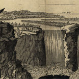
Plano de la Bahya de Mazaredo o de la Cascada situada en la costa meridional del Estrecho de Magallanes por latitud sur de 53p0s59ʹ30ʺ y ...
Depths shown by soundings.
Contributor: Bandujo, José F. - Bandujo, José F. Site: American Memory-cultural - Main Catalog Original Format: Map Date: 1700 View catalog record -

Sŏn yŏkto.
Romanized.
Site: American Memory-cultural - Main Catalog Original Format: Map Date: 1760 View catalog record -

Extrait de la carte hollandise representant la colonie de Surinam : sur le quel on a marque les voyages qu'a fait dans cette colonie Mr. ...
Cadastral map of eastern coast of Suriname.
Contributor: Mentelle, Simon M. Site: American Memory-cultural - Main Catalog Original Format: Map Date: 1777 View catalog record -

Plano topografico que comprende una parte del Montegrande, el Rio Yacuy, los establecimentos y misiones del Uruguay, los yervales que actualmento poseen los indios guaranias ...
Shows Uruguay River.
Contributor: Varela y Ulloa, Jos - Varela y Ulloa, Jose Site: American Memory-cultural - Main Catalog Original Format: Map Date: 1780 View catalog record -

Les isles Antilles, et le golfe du Méxique.
Scale ca. 1:12,000,000.
Contributor: Bonne, Rigobert Site: American Memory-cultural - Main Catalog Original Format: Map Date: 1780 View catalog record -

Carte de de [sic] l'Isle St. Christophe,
Scale ca. 1:78,000.
Contributor: Bellin, Jacques Nicolas Site: American Memory-cultural - Main Catalog Original Format: Map Date: 1780 View catalog record -

[Maps of the Maryland-Pennsylvania boundary used as trial exhibits in the 1735 court suit brought by the Penns against Lord Baltimore to determine the official ...
The maps also cover the Lower Counties (now the State of Delaware) which at the time were part of Pennsylvania.
Contributor: Senex, John Site: American Memory-cultural - Main Catalog Original Format: Map Date: 1732 View catalog record -

A new map of the island of Jamaica divided into its parishes : including the south end of Cuba and the west end of Hispaniola ...
Relief shown pictorially.
Contributor: Kitchin, Thomas Site: American Memory-cultural - Main Catalog Original Format: Map Date: 1765 View catalog record
Refine your search
Original Format
- Map
- Web Page [9]