Title: A Map of the Entire World According to the Traditional Method of Ptolemy and Corrected with Other Lands of Amerigo Vespucci
Description
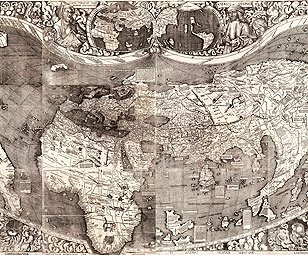
- Martin Waldseemüller's 1507 world map was the first map to depict a separate Western hemisphere with the Pacific as a separate ocean. The map grew out of an ambitious project in St. Dié, France, during the early 1500s, to document and update new geographic knowledge derived from the Portuguese and Spanish explorations of the late 15th and early 16th centuries. Waldseemüller's map was the most exciting product of that research effort. It drew upon data gathered during Amerigo Vespucci's 1501-02 voyages to the New World. In recognition of Vespucci's understanding that a new continent had been discovered, Waldseemüller christened the new lands "America." This is the only known surviving copy of the first edition of the map, of which it is believed 1,000 copies were printed. By showing the newly-found American land mass, the map represented a huge leap forward in knowledge – one that forever changed the European understanding of a world previously divided into just three parts: Europe, Asia, and Africa.
Creator
Publication Information
Language
Title in Original Language
-
Universalis cosmographia secundum Ptholomaei traditionem et Americi Vespucii alioru[m]que lustrationes
Place
Time
Topic
Additional Subjects
Type of Item
Physical Description
- 1 map on 12 sheets ; 128 x 233 centimeters, sheets 46 x 63 centimeters or smaller
Institution
External Resource