Title: Map of California Shown as an Island
Description
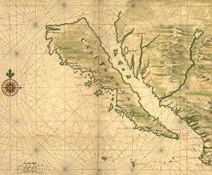
- Joan Vinckeboons (1617-70) was a Dutch cartographer and engraver born into a family of artists of Flemish origin. He was in the employ of the Dutch West India Company and produced maps for over 30 years for use by Dutch mercantile and military shipping. He was a business partner of Joan Blaeu, one of the most important map and atlas publishers of the day. Vinckeboons drew a series of 200 manuscript maps that were used in the production of atlases, including Blaeu’s Atlas Major. This map from around 1650 shows California as an island. A half-century would pass before Spanish explorers determined with certainty that California was connected to the mainland of North America. Place names are carefully indicated on the map in red and black, and include, for example, Cape San Lucas (at the tip of present-day Baja California), Mexico, and the Tres Maria Islands off the coast of the Mexican mainland. The map is part of the Henry Harrisse Manuscript Collection in the Library of Congress.
Cartographer
Language
Place
Time
Topic
Additional Subjects
Type of Item
Physical Description
- 1 pen-and-ink and watercolor manuscript map; 48 x 69 centimeters
Notes
- Scale approximately 1:7,000,000
Collection
Institution
External Resource
