| The Library of Congress | Global Gateway | [English] | [Français] |
 |
Themes | Collections | About the Site | Partners | Site Map | Advanced Search |
| Imperial Ambitions in Texts and Images | |||||||||
|
|
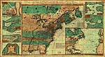
By the 1740s Franco-British imperial rivalry was nowhere more apparent than in the North American interior. French colonial authorities claimed sovereignty over a vast area comprising about one-third of the continent, including Canada, the Great Lakes region, the Ohio Valley, and all lands west of the Appalachian Mountains to the Mississippi River as far south as the Gulf of Mexico. British claims were no less extensive, but were asserted through the various colonies, which were quite autonomous and to some extent competed with each other. Virginia and Pennsylvania both claimed rights to the Ohio Valley; Massachusetts (which then included present-day Maine) had a disputed border with Canada; and Carolina claimed both Spanish Florida and French Louisiana. Documents produced in Europe and the colonies often were intended to bolster these conflicting claims. A map published in London in 1755 by the Anti-Gallican society, for example, showed the boundaries of Georgia, the Carolinas, and Virginia extending westward beyond the Mississippi. Colonial officials built up an enormous body of texts–official correspondence, memoranda, plans, as well as royal proclamations and laws–to legitimate territorial claims over lands and peoples that often were only nominally under their control. Maps in particular projected what their authors’ believed “ought to be” as much as what actually “was.” By asserting these ultimately irreconcilable claims, the French and British positioned themselves--politically, economically, and militarily--on a path of deliberate confrontation.
|
| The Library of Congress | Global Gateway | Contact Us Contactez-nous |
Legal Notices Notices Légales |
| The Library of Congress | Global Gateway | [English] | [Français] |
| Les Thèmes | Les Collections | Sur le site | Partenariats | Plan du site | Recherche Avançée |
| Les ambitions impérialistes en textes et en images | |||||||||
|
Les alliances franco-indiennes
Les Français et l’Amérique du Nord après le traité de Paris (1763-1803) |
Dans les années 1740, c’est en Amérique du Nord que la rivalité franco-britannique s’exprime avec le plus d’intensité, et dans la vallée de l’Ohio qu’elle se cristallise. La France revendique la souveraineté sur près d’un tiers du continent, du golfe du Saint-Laurent au golfe du Mexique en passant par les Grands Lacs et la vallée du Mississippi. Les prétentions britanniques ne sont pas moins importantes, mais elles émanent de diverses colonies parfois en compétition les unes avec les autres. La Pennsylvanie et la Virginie revendiquent toutes les deux la vallée de l’Ohio, le Massachusetts (qui comprenait alors le Maine) conteste le tracé de sa frontière avec le Canada tandis que la Caroline revendique à la fois la Floride espagnole et la Louisiane française. Chacune des parties produisait en Europe et dans les colonies des documents destinés à soutenir ses revendications territoriales. Ainsi se constitue un énorme corpus de textes (correspondance officielle, mémoires, plans, proclamations royales et lois). Les cartes, notamment, reflètent souvent davantage les ambitions que la réalité. En soutenant des prétentions contradictoires, Britanniques et Français s’inscrivent dans une logique délibérée d’affrontements.
|
| The Library of Congress | Global Gateway | Contact Us Contactez-nous |
Legal Notices Notices Légales |