| The Library of Congress | Global Gateway |
| Parallel Histories Home | Themes | Collections | About the Site | Partners | Site Map | Advanced Search |
Imperial Rivalries
|
| Parallel Histories Home >> Exploration and Early Settlement >> Atlantic & Gulf Coasts >> Imperial Rivalries |
 Timeline
Atlantic & Gulf Coasts The Southwest
Far West Timeline
Atlantic & Gulf Coasts The Southwest
Far West
|
Spain laid claim to the region from Florida to the Chesapeake Bay, but never effectively controlled this vast area in its entirety. Spain faced competition from other European powers, notably France and England. French Huguenots established Fort Caroline in Florida near the mouth of the St. Johns River in 1564. One objective of Pedro Menéndez de Avilés’1565 expedition was to eliminate French settlements in Florida from which the French could threaten the treasure ship fleets. Menéndez de Avilés attacked the French garrison, burned the settlement, and slaughtered all its inhabitants. In 1585-86 Sir Francis Drake (ca. 1540-1543-January 28, 1596) made raids on behalf of the English on various communities in Florida and the Caribbean, including St. Augustine, Santiago de Cuba, Santo Domingo, and Cartagena. St. Augustine was looted and burned. England later established colonies in Georgia and North Carolina. In 1702 the English again sacked St. Augustine and destroyed the Spanish missions in northern Florida. The dramatic voyage of René-Robert Cavelier, Sieur de La Salle (1643-1687) down the Mississippi River to its mouth and the French claim to an immense territory it named "La Louisiane" shocked the Spanish. Prior to that voyage, the area along the Gulf Coast had been considered exclusively Spanish territory. The Spaniards mounted a series of expeditions into east Texas in search of French encroachments on Spanish territory. La Salle supposedly had built a Fort St. Louis in Texas, but it was destroyed by Karankawa Indians. In 1689 one of the Spanish expeditions reported that they had found the remains of the fort and rescued French children--four brothers and a sister--from nearby tribes. Still, by the early 18th century, France had established settlements along the Gulf Coast at Mobile, Biloxi, and New Orleans to strengthen its original claims. In 1762 France ceded Louisiana to Spain, which in turn ceded most of Florida to England in exchange for the recently captured Havana. The Spaniards later fought alongside the Americans during the Revolutionary War, but the rapid growth of the new United States rendered Spain’s presence in North America increasingly precarious. Don Bernardo de Gálvez’s victories in Mobile and Pensacola drove the British out of Spanish West Florida. By 1813, however, Spain controlled only the Pensacola area of west Florida. In 1821 Andrew Jackson formally accepted the cession of the remaining part of Spanish Florida to the United States. 1. Amerigo Vespucci (1452-1512), a Florentine navigator, undertook voyages for Spain and Portugal. His writings were widely circulated in Europe in the early 1500s, which helps to explain why the German mapmaker Martin Waldseemüller (ca.1470–ca.1518) called the New World “America” in his famous 1507 map. 2. French contacts with the Timucua peoples of what is now northern Florida were documented by Jacques Le Moyne. Here, the alliance of the French with Chief Outina is used to overwhelm his archenemy Potanou. Further French and Spanish struggles are described in the presentation France in America, especially in the section on The Struggle for Pensacola. 3. It is possible that this map was produced, at the request of Spain, by Antoine Perrenot de Granvelle (August 20, 1517-September 21, 1586), Spanish negotiator with the French and English for the 1559 Treaty of Cateau Cambrésis. Further details are described in the American Memory special presentation essay in the section on The 1562 Map of America by Diego Gutiérrez. 4. The French artist Jacques Le Moyne visited Fort Caroline in 1564 and later produced this early map of Florida. 5. Spain’s claims to large parts of what later became the southeastern United States were based in part in de Soto’s journey, as shown in this Spanish map of 1742. Arredondo sought to demonstrate that the British colony of Georgia was illegally sited on Spanish territory. In the 16th century, Spain considered Florida a geographic entity which extended north to the Chesapeake Bay and west beyond the Mississippi River, as can be seen in Arredondo's map. 6. In 1585-86 Drake made raids on various communities in the West Indies, including St. Augustine, Santiago de Cuba, Santo Domingo, and Cartagena. Baptista Boazio (fl.1588), an Italian artist resident in London, made engravings of the attacks on each city, from drawings possibly obtained from Drake himself. 7. Don Bernardo de Gálvez won victories in Mobile and Pensacola that drove the British out of Spanish West Florida. |
 Anthology of miscellaneous materials in the Italian language, Amerigo Vespucci et al. [Florence, third quarter of the 16th century]. Item 1, 1 leaf. Collection of Spanish American documents of Hans Peter Kraus. Manuscript Division. Library of Congress. (1)  Outina over Potanou. Photoreproduction from La Floride française, scène de la vie indienne, peintes en 1564. Theodor de Bry and Charles de la Roncière. [facsimile of the 1564 original (Paris, 1928)]. Rare Book and Special Collections Division. Library of Congress. (2) 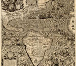 Americae sive quartae orbis partis nova et exactissima descriptio [North and South America]. Diego Gutiérrez. 1562. Geography and Map Division. Library of Congress. (3) 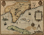 Floridae Americae provinciae recens & exactissima descriptio auctorè Iacobo le Moyne cui cognomen de Morgues… [Map of Florida…]. Le Moyne. [1591]. Geography and Map Division. Library of Congress. (4)  Demostracion historiografica del derecho que tiene el Rey Catholico…, [Historiographic demonstration of the rights of His Catholic Majesty…. Antonio de Arredondo]. 1742. Collection of Spanish American documents of Hans Peter Kraus. Manuscript Division. Library of Congress. (5) 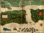 St. Augustine [Hand-colored engraved map]. 1586. Rare Book and Special Collections Division. Library of Congress. (6) 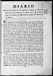 Diario de las operaciones de la expedicion contra la Plaza de Panzacola. [Operational Diary of the Expedition against Pensacola]. Don Bernardo de Gálvez. [1781?]. Rare Book and Special Collections Division. Library of Congress. (7) |
| The Library of Congress | Global Gateway | Contact Us Contáctenos |
Legal Notices Notas legales |
| The Library of Congress | Global Gateway |
| Historias Paralelas Inicio | Temas | Colecciones | Información sobre el sitio | Instituciones participantes | Mapa del sitio | Búsqueda avanzada |
Rivalidades Imperiales
|
| Historias Paralelas Inicio >> Exploración y Primeros Asentamientos >> Las Costas del Atlántico y del Golfo >> Rivalidades Imperiales |
|
Cronología
Las Costas del Atlántico y del Golfo El Suroeste
El Lejano Oeste
|
España reivindicó como propia la región que iba desde Florida a la Bahía de Chesapeake, pero nunca la llegó a controlar de manera efectiva. España se tuvo que enfrentar a la rivalidad de otras potencias europeas, notablemente Francia e Inglaterra. Hugonotes franceses establecieron Fort Caroline en Florida en 1564, cerca de la desembocadura del Río San Juan. Uno de los objetivos de la expedición de Pedro Menéndez de Avilés en 1565 era el eliminar los asentamientos franceses en Florida, desde donde podrían ser un peligro para las flotas de tesoro español. Menéndez de Avilés atacó la guarnición francesa, quemó el asentamiento y masacró a todos sus habitantes. En 1585-86 Sir Francis Drake (ca. 1540-1596) hizo varias incursiones en nombre de los ingleses a varias comunidades en Florida y el Caribe, incluyendo San Agustín, Santiago de Cuba, Santo Domingo y Cartagena. San Agustín fue saqueada y quemada. Más tarde, Inglaterra estableció colonias en Georgia y Carolina del Norte. En 1702, los ingleses de nuevo saquearon San Agustín y destruyeron las misiones españolas del norte de Florida. El dramático viaje de René-Robert Cavelier, Señor de La Salle (1643-1687) siguiendo la corriente del Misisipi hacia el sur hasta llegar a su desembocadura y la reivindicación por parte de Francia de tan inmenso territorio, al que llamó “La Louisiane” horrorizó a los españoles. Antes de ese viaje, la región comprendida a lo largo de zona costera del Golfo había sido considerada exclusivamente territorio español. La Salle supuestamente había construido un fuerte en Fort St. Louis, Texas, pero fue destruido por los indios Karankawa. En 1689 una de las expediciones españolas había informado que había encontrado los restos del fuerte y que habían rescatado a niños franceses—cuatro hermanos y una hermana—de las tribus de las cercanías. Más todavía, para principios del siglo XVIII, Francia había establecido asentamientos a lo largo de la Costa del Golfo, en Mobile, Biloxi y Nueva Orleáns, para fortalecer sus reivindicaciones territoriales. En 1762, Francia cedió Luisiana a España, quien a su vez cedió casi toda la Florida a Inglaterra como intercambio por la recién capturada ciudad de La Habana. Más tarde los españoles lucharon al lado de los americanos durante la Guerra de Independencia. Las victorias de Bernardo de Gálvez en Mobile y Pensacola expulsaron a los británicos del oeste de Florida. Pero el rápido crecimiento de los nuevos Estados Unidos hacía la presencia de España en norteamérica cada vez más precaria. Así para 1813, España solo controlaba el área de Pensacola, en el oeste de la Florida. Y en 1821, Andrew Jackson aceptó formalmente la cesión del resto de la Florida española a los Estados Unidos. 1. Américo Vespucio (1452-1512), fue un navegante florentino al servicio de España y Portugal. Sus escritos circularon ampliamente en Europa a principios del siglo XVI, lo que ayuda a explicar el por qué el cartógrafo alemán Martin Waldseemüller (ca. 1470—ca.1518) llamó “América” al Nuevo Mundo en su famoso mapa de 1507. 2. Los contactos franceses con los Timucúas en lo que es hoy el norte de Florida fueron documentados por Jacques Le Moyne. Aquí, la alianza de los franceses con el jefe Outina es usada para aplastar a Potanou, su acérrimo enemigo. Información adicional sobre la rivalidad franco-española se puede encontrar en France in America, concretamente en la sección sobre The Struggle for Pensacola. 3. Es posible que este mapa haya sido trazado a petición de España por Perrenot de Granvelle (1517-1586), un negociador español con los franceses e ingleses para el Tratado de Cateau Cambrésis de 1559. Para obtener más información sobre el Mapa de América de 1562 por Diego Gutiérrez seleccione este enlace sobre el mapa. 4. El artista francés Jacques LeMoyne visitó Ft. Caroline en 1562 y más tarde trazó uno de los primeros mapas de Florida. 5. La reivindicaciones territoriales españolas para lo que más tarde fue la zona sur-oriental de los Estados Unidos, se basaban en parte por el viaje de de Soto, como muestra este mapa español de 1742. Arredondo trató de demostrar que la colonia británica de Georgia estaba ilegalmente ubicada en territorio español. En el siglo XVI, España consideró a Florida como una entidad geográfica que se extendía por el norte hasta la Bahía de Chesapeake y por el oeste más allá del río Misisipi, como se puede ver en este mapa de Arredondo. 6. En 1585-86 Drake atacó varias comunidades en la Indias Occidentales, incluyendo San Agustín, Santiago de Cuba, Santo Domingo y Cartagena. Baptista Boazio (fl. 1588), un artista italiano residente en Londres, hizo grabados de los ataques a cada ciudad, usando dibujos posiblemente obtenidos del propio Drake. 7. Don Bernardo de Gálvez obtuvo victorias en Mobile y Pensacola que forzaron a los ingleses fuera de la Florida occidental española. |
Anthology of miscellaneous materials in the Italian language, Amerigo Vespucci et al. [Florence, third quarter of the 16th century]. Item 1, 1 leaf. Collection of Spanish American documents of Hans Peter Kraus. Manuscript Division. Library of Congress. (1) Outina over Potanou. Photoreproduction from La Floride française, scène de la vie indienne, peintes en 1564. Theodor de Bry and Charles de la Roncière. [facsimile of the 1564 original (Paris, 1928)]. Rare Book and Special Collections Division. Library of Congress. (2) Americae sive quartae orbis partis nova et exactissima descriptio [North and South America]. Diego Gutiérrez. 1562. Geography and Map Division. Library of Congress. (3) Floridae Americae provinciae recens & exactissima descriptio auctorè Iacobo le Moyne cui cognomen de Morgues… [Map of Florida…]. Le Moyne. [1591]. Geography and Map Division. Library of Congress. (4) Demostracion historiografica del derecho que tiene el Rey Catholico…, [Historiographic demonstration of the rights of His Catholic Majesty…. Antonio de Arredondo]. 1742. Collection of Spanish American documents of Hans Peter Kraus. Manuscript Division. Library of Congress. (5) St. Augustine [Hand-colored engraved map]. 1586. Rare Book and Special Collections Division. Library of Congress. (6) Diario de las operaciones de la expedicion contra la Plaza de Panzacola. [Operational Diary of the Expedition against Pensacola]. Don Bernardo de Gálvez. [1781?]. Rare Book and Special Collections Division. Library of Congress. (7) |
| The Library of Congress | Global Gateway | Contact Us Contáctenos |
Legal Notices Notas legales |