Map
Map used by Jed. Hotchkiss, Top. Eng., 2d Corps, A.N. Va., in campaign of 1864 : [Richmond, Virginia region].

| Format |
Map |
|---|---|
| Contributors |
Hotchkiss, Jedediah |
| Dates |
1864 |
| Location |
Richmond Region United States Virginia |
| Language |
English |
| Subjects |
Landowners Richmond Region Richmond Region (Va.) United States Virginia |
- Title
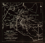
- Map used by Jed. Hotchkiss, Top. Eng., 2d Corps, A.N. Va., in campaign of 1864 : [Richmond, Virginia region].
- Description
-
Shows Richmond and surrounding areas and names of some residents.
-
Also shows radial distances from Richmond.
-
Pen-and-ink and pencil (some col.) on irregularly shaped sheet of tracing linen, mounted on cloth.
-
LC Civil War maps (2nd ed.), H179
-
Title from verso partially obscured by mounting.
-
Available also through the Library of Congress web site as raster image.
-
In pencil on verso: 448.
-
1 ms. map : col., cloth ; 23 x 26 cm.
- Creator
- Hotchkiss, Jedediah,
- Subject Headings
-
-
Richmond Region (Va.)
-
-
Landowners--Virginia--Richmond Region
-
-
United States--Virginia--Richmond Region.
- Notes
-
-
Shows Richmond and surrounding areas and names of some residents.
-
-
Also shows radial distances from Richmond.
-
-
Pen-and-ink and pencil (some col.) on irregularly shaped sheet of tracing linen, mounted on cloth.
-
-
LC Civil War maps (2nd ed.), H179
-
-
Title from verso partially obscured by mounting.
-
-
Available also through the Library of Congress web site as raster image.
-
-
In pencil on verso: 448.
- Medium
-
1 ms. map : col., cloth ; 23 x 26 cm.
- Call Number
-
G3884.R5A1 1864 .H6
- Repository
-
Library of Congress Geography and Map Division Washington, D.C. 20540-4650 dcu
- Digital Id
-
g3884r cwh00179 http://hdl.loc.gov/loc.gmd/g3884r.cwh00179
- Library of Congress Catalog Number
- 2005625086
Rights & Access
The maps in the Map Collections materials were either published prior to 1922, produced by the United States government, or both (see catalogue records that accompany each map for information regarding date of publication and source). The Library of Congress is providing access to these materials for educational and research purposes and is not aware of any U.S. copyright protection (see Title 17 of the United States Code) or any other restrictions in the Map Collection materials.
Note that the written permission of the copyright owners and/or other rights holders (such as publicity and/or privacy rights) is required for distribution, reproduction, or other use of protected items beyond that allowed by fair use or other statutory exemptions. Responsibility for making an independent legal assessment of an item and securing any necessary permissions ultimately rests with persons desiring to use the item.
More about Copyright and other Restrictions
For guidance about compiling full citations consult Citing Primary Sources.
Part of...
-
Hotchkiss Map Collection
[345]
-
Civil War Maps
[2281]
-
Military Battles And Campaigns Cartographic Items
[3867]
-
Geography And Maps Division
[60803]
-
American Memory
[1121009]
More maps like this
-
 Thirty five miles around Richmond, Va. /
Contributor:
Hotchkiss, Jedediah
Site:
American Memory-cultural, Main Catalog
Original Format:
Map
Date:
1867
View catalog record
Thirty five miles around Richmond, Va. /
Contributor:
Hotchkiss, Jedediah
Site:
American Memory-cultural, Main Catalog
Original Format:
Map
Date:
1867
View catalog record
-
 Richmond & vicinity.
Site:
American Memory-cultural, Main Catalog
Original Format:
Map
View catalog record
Richmond & vicinity.
Site:
American Memory-cultural, Main Catalog
Original Format:
Map
View catalog record
-
 Map of the country between Richmond and Petersburg /
Contributor:
Gilmer, Jeremy Francis
Site:
American Memory-cultural, Main Catalog
Original Format:
Map
Date:
1864
View catalog record
Map of the country between Richmond and Petersburg /
Contributor:
Gilmer, Jeremy Francis
Site:
American Memory-cultural, Main Catalog
Original Format:
Map
Date:
1864
View catalog record
-
 Map of the Confederate lines from New Bridge road to Chafins Bluff /
Contributor:
Stevens, W. H.
Site:
American Memory-cultural, Main Catalog
Original Format:
Map
Date:
1864
View catalog record
Map of the Confederate lines from New Bridge road to Chafins Bluff /
Contributor:
Stevens, W. H.
Site:
American Memory-cultural, Main Catalog
Original Format:
Map
Date:
1864
View catalog record
-
 Region embraced in the operations of the armies against Richmond and Petersburg
Contributor:
United States. Army. Corps of Engineers
Site:
American Memory-cultural, Main Catalog
Original Format:
Map
Date:
1865
View catalog record
Region embraced in the operations of the armies against Richmond and Petersburg
Contributor:
United States. Army. Corps of Engineers
Site:
American Memory-cultural, Main Catalog
Original Format:
Map
Date:
1865
View catalog record
-
 [Military map of Richmond and vicinity] /
Contributor:
United States Coast Survey
Site:
American Memory-cultural, Main Catalog
Original Format:
Map
Date:
1864
View catalog record
[Military map of Richmond and vicinity] /
Contributor:
United States Coast Survey
Site:
American Memory-cultural, Main Catalog
Original Format:
Map
Date:
1864
View catalog record
-
 Region embraced in the operations of the armies against Richmond and Petersburg /
Contributor:
United States. Army. Corps of Engineers
Site:
American Memory-cultural, Main Catalog
Original Format:
Map
Date:
1865
View catalog record
Region embraced in the operations of the armies against Richmond and Petersburg /
Contributor:
United States. Army. Corps of Engineers
Site:
American Memory-cultural, Main Catalog
Original Format:
Map
Date:
1865
View catalog record
-
 [Seven Days' battles, Virginia, June 25-July 1, 1862] /
Contributor:
Landers, Howard Lee
Site:
American Memory-cultural, Main Catalog
Original Format:
Map
Date:
1929-01-01
View catalog record
[Seven Days' battles, Virginia, June 25-July 1, 1862] /
Contributor:
Landers, Howard Lee
Site:
American Memory-cultural, Main Catalog
Original Format:
Map
Date:
1929-01-01
View catalog record
-
 [Map of the vicinity of Richmond, north and east of the James River].
Site:
American Memory-cultural, Main Catalog
Original Format:
Map
Date:
1864
View catalog record
[Map of the vicinity of Richmond, north and east of the James River].
Site:
American Memory-cultural, Main Catalog
Original Format:
Map
Date:
1864
View catalog record
-
 Map of vicinity of Richmond /
Contributor:
Campbell, Albert H.
Site:
American Memory-cultural, Main Catalog
Original Format:
Map
Date:
1864
View catalog record
Map of vicinity of Richmond /
Contributor:
Campbell, Albert H.
Site:
American Memory-cultural, Main Catalog
Original Format:
Map
Date:
1864
View catalog record
-
 Map of the country between Richmond and Petersburg
Contributor:
Gilmer, Jeremy Francis
Site:
American Memory-cultural
Original Format:
Map
Date:
1864
Map of the country between Richmond and Petersburg
Contributor:
Gilmer, Jeremy Francis
Site:
American Memory-cultural
Original Format:
Map
Date:
1864
-
 A topographical map of the city of Richmond and vicinity : from official data /
Contributor:
Colton, G. Woolworth
Site:
American Memory-cultural, Main Catalog
Original Format:
Map
Date:
1865
View catalog record
A topographical map of the city of Richmond and vicinity : from official data /
Contributor:
Colton, G. Woolworth
Site:
American Memory-cultural, Main Catalog
Original Format:
Map
Date:
1865
View catalog record
-
 Position of Richmond, Va. /
Contributor:
Abbot, Henry L.
Site:
American Memory-cultural, Main Catalog
Original Format:
Map
Date:
1862
View catalog record
Position of Richmond, Va. /
Contributor:
Abbot, Henry L.
Site:
American Memory-cultural, Main Catalog
Original Format:
Map
Date:
1862
View catalog record
-
 Copy of section of photograph map captured from the enemy, showing country adjacent to Richmond and lines of defensive works surrounding the city. /
Contributor:
United States. Army of the Potomac. Engineer Dept
Site:
American Memory-cultural, Main Catalog
Original Format:
Map
Date:
1864
View catalog record
Copy of section of photograph map captured from the enemy, showing country adjacent to Richmond and lines of defensive works surrounding the city. /
Contributor:
United States. Army of the Potomac. Engineer Dept
Site:
American Memory-cultural, Main Catalog
Original Format:
Map
Date:
1864
View catalog record
-
 [Richmond, vicinity].
Site:
American Memory-cultural, Main Catalog
Original Format:
Map
View catalog record
[Richmond, vicinity].
Site:
American Memory-cultural, Main Catalog
Original Format:
Map
View catalog record
You might also like
-
 The Boardwalk, Pine Beach, Va.
Contributor:
Detroit Publishing Co
Site:
Prints & Photographs
Original Format:
Photo, Print, Drawing
Date:
1906
The Boardwalk, Pine Beach, Va.
Contributor:
Detroit Publishing Co
Site:
Prints & Photographs
Original Format:
Photo, Print, Drawing
Date:
1906
-
 Pine Beach Hotel, Pine Beach, Va.
Contributor:
Detroit Publishing Co
Site:
Prints & Photographs
Original Format:
Photo, Print, Drawing
Date:
1906
Pine Beach Hotel, Pine Beach, Va.
Contributor:
Detroit Publishing Co
Site:
Prints & Photographs
Original Format:
Photo, Print, Drawing
Date:
1906
-
 Amusements and boardwalk, Pine Beach, Va.
Contributor:
Detroit Publishing Co
Site:
Prints & Photographs
Original Format:
Photo, Print, Drawing
Date:
1906
Amusements and boardwalk, Pine Beach, Va.
Contributor:
Detroit Publishing Co
Site:
Prints & Photographs
Original Format:
Photo, Print, Drawing
Date:
1906
-
 Pine Beach Hotel, Pine Beach, Va.
Contributor:
Detroit Publishing Co
Site:
Prints & Photographs
Original Format:
Photo, Print, Drawing
Date:
1906
Pine Beach Hotel, Pine Beach, Va.
Contributor:
Detroit Publishing Co
Site:
Prints & Photographs
Original Format:
Photo, Print, Drawing
Date:
1906
-

 Letter from B. W. Leigh, Esq., to the General Assembly of Virginia.
Contributor:
Leigh, Benjamin Watkins
Site:
Main Catalog
Original Format:
Book
Date:
1836
Letter from B. W. Leigh, Esq., to the General Assembly of Virginia.
Contributor:
Leigh, Benjamin Watkins
Site:
Main Catalog
Original Format:
Book
Date:
1836
-
The need for greater consolidation or coordination of workforce development and training resources in the Commonwealth : report of the Joint Subcommittee Studying the Need ...
Site:
Main Catalog
Original Format:
Book
Date:
2006