Map
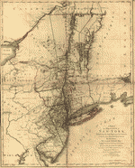
A map of the Province of New-York, reduc'd from the large drawing of that Province, compiled from actual surveys by order of His Excellency William Tryon, Esqr. Captain General & Governor of the same,
| Format |
Map |
|---|---|
| Contributors |
Sauthier, Claude Joseph |
| Dates |
1776 |
| Location |
United States New Jersey New York Northeastern States |
| Language |
English |
| Subjects |
Administrative And Political Divisions New Jersey New York (State) Northeastern States United States |
- Title
- A map of the Province of New-York, reduc'd from the large drawing of that Province, compiled from actual surveys by order of His Excellency William Tryon, Esqr. Captain General & Governor of the same,
- Creator
- Sauthier, Claude Joseph.
- Created Published
-
London, W. Faden, 1776.
- Subject Headings
-
-
New York (State)--Administrative and political divisions
-
-
New Jersey--Administrative and political divisions
-
-
United States--New York (State)
-
-
United States--New Jersey.
-
-
United States--Northeastern States.
- Notes
-
-
Scale ca. 1:1,000,000.
-
-
Hand colored.
-
-
Relief shown by hachures.
-
-
Prime meridian: New York.
-
-
Shows administrative boundaries in New York and New Jersey. Also shows portions of Pennsylvania and New England.
-
-
LC Maps of North America, 1750-1789, 1047
-
-
Available also through the Library of Congress Web site as a raster image.
- Call Number
-
G3800 1776 .S3
- Repository
-
Library of Congress Geography and Map Division Washington, D.C. 20540-4650 USA dcu
- Digital Id
-
g3800 ar104703 http://hdl.loc.gov/loc.gmd/g3800.ar104703
- Library of Congress Catalog Number
- gm 71005418
Rights & Access
The maps in the Map Collections materials were either published prior to 1922, produced by the United States government, or both (see catalogue records that accompany each map for information regarding date of publication and source). The Library of Congress is providing access to these materials for educational and research purposes and is not aware of any U.S. copyright protection (see Title 17 of the United States Code) or any other restrictions in the Map Collection materials.
Note that the written permission of the copyright owners and/or other rights holders (such as publicity and/or privacy rights) is required for distribution, reproduction, or other use of protected items beyond that allowed by fair use or other statutory exemptions. Responsibility for making an independent legal assessment of an item and securing any necessary permissions ultimately rests with persons desiring to use the item.
More about Copyright and other Restrictions
For guidance about compiling full citations consult Citing Primary Sources.
Part of...
More maps like this
-
 A map of the Province of New-York reduc'd from the large drawing of that Province, compiled from actual surveys by order of His Excellency William ...
Contributor:
Sauthier, Claude Joseph
Site:
American Memory-cultural, Main Catalog
Original Format:
Map
Date:
1776
View catalog record
A map of the Province of New-York reduc'd from the large drawing of that Province, compiled from actual surveys by order of His Excellency William ...
Contributor:
Sauthier, Claude Joseph
Site:
American Memory-cultural, Main Catalog
Original Format:
Map
Date:
1776
View catalog record
-
 A map of the Province of New-York, reduc'd from the large drawing of that Province, compiled from actual surveys by order of His Excellency William ...
Contributor:
Sauthier, Claude Joseph
Site:
American Memory-cultural, Main Catalog
Original Format:
Map
Date:
1776
View catalog record
A map of the Province of New-York, reduc'd from the large drawing of that Province, compiled from actual surveys by order of His Excellency William ...
Contributor:
Sauthier, Claude Joseph
Site:
American Memory-cultural, Main Catalog
Original Format:
Map
Date:
1776
View catalog record
-
 A map of the provinces of New-York and New Jersey, with a part of Pennsylvania and the Province of Quebec.
Contributor:
Sauthier, Claude Joseph
Site:
American Memory-cultural, Main Catalog
Original Format:
Map
Date:
1777
View catalog record
A map of the provinces of New-York and New Jersey, with a part of Pennsylvania and the Province of Quebec.
Contributor:
Sauthier, Claude Joseph
Site:
American Memory-cultural, Main Catalog
Original Format:
Map
Date:
1777
View catalog record
-
 A map of the provinces of New-York and New-Yersey, with a part of Pennsylvania and the Province of Quebec.
Contributor:
Sauthier, Claude Joseph
Site:
American Memory-cultural, Main Catalog
Original Format:
Map
Date:
1777
View catalog record
A map of the provinces of New-York and New-Yersey, with a part of Pennsylvania and the Province of Quebec.
Contributor:
Sauthier, Claude Joseph
Site:
American Memory-cultural, Main Catalog
Original Format:
Map
Date:
1777
View catalog record
-
 A chorographical map of the Province of New-York in North America, divided into counties, manors, patents and townships; exhibiting likewise all the private grants of ...
Contributor:
Sauthier, Claude Joseph
Site:
American Memory-cultural, Main Catalog
Original Format:
Map
Date:
1779
View catalog record
A chorographical map of the Province of New-York in North America, divided into counties, manors, patents and townships; exhibiting likewise all the private grants of ...
Contributor:
Sauthier, Claude Joseph
Site:
American Memory-cultural, Main Catalog
Original Format:
Map
Date:
1779
View catalog record
-
 A topographical map of Hudsons River, with the channels depth of water, rocks, shoals &c. and the country adjacent, from Sandy-Hook, New York and bay ...
Contributor:
Sauthier, Claude Joseph
Site:
American Memory-cultural, Main Catalog
Original Format:
Map
Date:
1777
View catalog record
A topographical map of Hudsons River, with the channels depth of water, rocks, shoals &c. and the country adjacent, from Sandy-Hook, New York and bay ...
Contributor:
Sauthier, Claude Joseph
Site:
American Memory-cultural, Main Catalog
Original Format:
Map
Date:
1777
View catalog record
-
 A plan of the operations of the King's army under the command of General Sir William Howe, K.B. in New York and east New Jersey, ...
Contributor:
Sauthier, Claude Joseph
Site:
American Memory-cultural, Main Catalog
Original Format:
Map
Date:
1776
View catalog record
A plan of the operations of the King's army under the command of General Sir William Howe, K.B. in New York and east New Jersey, ...
Contributor:
Sauthier, Claude Joseph
Site:
American Memory-cultural, Main Catalog
Original Format:
Map
Date:
1776
View catalog record
-
 A plan of the operations of the King's army under the command of General Sr. William Howe, K.B. in New York and east New Jersey ...
Contributor:
Sauthier, Claude Joseph
Site:
American Memory-cultural, Main Catalog
Original Format:
Map
Date:
1777
View catalog record
A plan of the operations of the King's army under the command of General Sr. William Howe, K.B. in New York and east New Jersey ...
Contributor:
Sauthier, Claude Joseph
Site:
American Memory-cultural, Main Catalog
Original Format:
Map
Date:
1777
View catalog record
-
 Mappa geographica Provinciæ Nova Eboraci ab Anglis New-York dictæ ex ampliori delineatione ad exactas dimensiones concinnata in arctius spatium redacta cura Claudii Josephi Sauthier cui ...
Contributor:
Homann Erben (Firm)
Site:
American Memory-cultural, Main Catalog
Original Format:
Map
Date:
1778
View catalog record
Mappa geographica Provinciæ Nova Eboraci ab Anglis New-York dictæ ex ampliori delineatione ad exactas dimensiones concinnata in arctius spatium redacta cura Claudii Josephi Sauthier cui ...
Contributor:
Homann Erben (Firm)
Site:
American Memory-cultural, Main Catalog
Original Format:
Map
Date:
1778
View catalog record
-
 A plan of Fort George at the city of New-York.
Contributor:
Sauthier, Claude Joseph
Site:
American Memory-cultural, Main Catalog
Original Format:
Map
Date:
1773
View catalog record
A plan of Fort George at the city of New-York.
Contributor:
Sauthier, Claude Joseph
Site:
American Memory-cultural, Main Catalog
Original Format:
Map
Date:
1773
View catalog record
-
 A tracing relating to Fort Washington or Knyphausen.
Contributor:
Sauthier, Claude Joseph
Site:
American Memory-cultural, Main Catalog
Original Format:
Map
Date:
1776
View catalog record
A tracing relating to Fort Washington or Knyphausen.
Contributor:
Sauthier, Claude Joseph
Site:
American Memory-cultural, Main Catalog
Original Format:
Map
Date:
1776
View catalog record
-
 A map of part of New-York Island showing a plan of Fort Washington, now call'd Ft. Kniphausen with the rebels lines on the south part, ...
Contributor:
Sauthier, Claude Joseph
Site:
American Memory-cultural, Main Catalog
Original Format:
Map
Date:
1776
View catalog record
A map of part of New-York Island showing a plan of Fort Washington, now call'd Ft. Kniphausen with the rebels lines on the south part, ...
Contributor:
Sauthier, Claude Joseph
Site:
American Memory-cultural, Main Catalog
Original Format:
Map
Date:
1776
View catalog record
-
 A topographical map of the northn. part of New York Island, exhibiting the plan of Fort Washington, now Fort Knyphausen, with the rebels lines to ...
Contributor:
Sauthier, Claude Joseph
Site:
American Memory-cultural, Main Catalog
Original Format:
Map
Date:
1777
View catalog record
A topographical map of the northn. part of New York Island, exhibiting the plan of Fort Washington, now Fort Knyphausen, with the rebels lines to ...
Contributor:
Sauthier, Claude Joseph
Site:
American Memory-cultural, Main Catalog
Original Format:
Map
Date:
1777
View catalog record
-
 A plan of the attack of Fort Washington, now Fort Knyphausen, and of the American lines on New-York Island by the King's troops, on the ...
Contributor:
Sauthier, Claude Joseph
Site:
American Memory-cultural, Main Catalog
Original Format:
Map
Date:
1776
View catalog record
A plan of the attack of Fort Washington, now Fort Knyphausen, and of the American lines on New-York Island by the King's troops, on the ...
Contributor:
Sauthier, Claude Joseph
Site:
American Memory-cultural, Main Catalog
Original Format:
Map
Date:
1776
View catalog record
-
 A topographical map of the northn. part of New York Island, exhibiting the plan of Fort Washington, now Fort Knyphausen, with the rebels lines to ...
Contributor:
Sauthier, Claude Joseph
Site:
American Memory-cultural, Main Catalog
Original Format:
Map
Date:
1777
View catalog record
A topographical map of the northn. part of New York Island, exhibiting the plan of Fort Washington, now Fort Knyphausen, with the rebels lines to ...
Contributor:
Sauthier, Claude Joseph
Site:
American Memory-cultural, Main Catalog
Original Format:
Map
Date:
1777
View catalog record
-
 Province de New-York en 4 feuilles,
Contributor:
Montrésor, John, Montrésor, John
Site:
American Memory-cultural, Main Catalog
Original Format:
Map
Date:
1777
View catalog record
Province de New-York en 4 feuilles,
Contributor:
Montrésor, John, Montrésor, John
Site:
American Memory-cultural, Main Catalog
Original Format:
Map
Date:
1777
View catalog record
You might also like
-
 Early years, snapshots, 1896-1898. Railroad scenes III
Contributor:
Gottscho, Samuel H. (Samuel Herman)
Site:
Prints & Photographs
Original Format:
Photo, Print, Drawing
Date:
1896
Early years, snapshots, 1896-1898. Railroad scenes III
Contributor:
Gottscho, Samuel H. (Samuel Herman)
Site:
Prints & Photographs
Original Format:
Photo, Print, Drawing
Date:
1896
-
 Ferry boats still transport some of the traffic between New York City and Jersey
Contributor:
Lange, Dorothea
Site:
Prints & Photographs
Original Format:
Photo, Print, Drawing
Date:
1939
Ferry boats still transport some of the traffic between New York City and Jersey
Contributor:
Lange, Dorothea
Site:
Prints & Photographs
Original Format:
Photo, Print, Drawing
Date:
1939
-
Ferry boats still transport some of the traffic between New York City and Jersey
Contributor:
Lange, Dorothea
Site:
Prints & Photographs
Original Format:
Photo, Print, Drawing
Date:
1939
-
Ferry boats still transport some of the traffic between New York City and Jersey
Contributor:
Lange, Dorothea
Site:
Prints & Photographs
Original Format:
Photo, Print, Drawing
Date:
1939
-
 [The Hudson River & Riverside Park, New York, N.Y.]
Contributor:
Detroit Publishing Co
Site:
Prints & Photographs
Original Format:
Photo, Print, Drawing
Date:
1900
[The Hudson River & Riverside Park, New York, N.Y.]
Contributor:
Detroit Publishing Co
Site:
Prints & Photographs
Original Format:
Photo, Print, Drawing
Date:
1900
-
 Oil spill hotline
Contributor:
United States. Environmental Protection Agency
Site:
Prints & Photographs
Original Format:
Photo, Print, Drawing
Date:
1965
Oil spill hotline
Contributor:
United States. Environmental Protection Agency
Site:
Prints & Photographs
Original Format:
Photo, Print, Drawing
Date:
1965