![Carte particulière d'une partie de la Louisianne ou les fleuve et rivierres [i.e. rivières] onts etés relevé a l'estime & les routtes [i.e. routes] par terre relevé & mesurées aux pas, par les Srs. Broutin, de Vergés, ingénieurs & Saucier dessinateur](https://cybercemetery.unt.edu/archive/oilspill/20121207202657im_/http://www.loc.gov/collections/static/louisiana-european-explorations-and-the-louisiana-purchase/images/ct000681.jpg)


![[Sketch of the battles of Chancellorsville, Salem Church, and Fredericksburg], May 2, 3, and 4, 1863](https://cybercemetery.unt.edu/archive/oilspill/20121207202657im_/http://www.loc.gov/collections/static/civil-war-maps/images/cwh00129.jpg)

![[Map of parts of Caroline, Hanover, and Henrico counties, Va. west of the Mattaponi River and the Richmond, Fredericksburg, and Potomac Railroad].](https://cybercemetery.unt.edu/archive/oilspill/20121207202657im_/http://www.loc.gov/collections/static/hotchkiss-maps/images/cwh00025.jpg)
![[Base map of Pennsylvania].](https://cybercemetery.unt.edu/archive/oilspill/20121207202657im_/http://www.loc.gov/collections/static/hotchkiss-maps/images/cwh00207.jpg)

![[January 3, 1945], HQ Twelfth Army Group situation map.](https://cybercemetery.unt.edu/archive/oilspill/20121207202657im_/http://www.loc.gov/collections/static/world-war-II-maps-military-situation-maps-from-1944-to-1945/images/ict21213.jpg)
![[December 21, 1944], HQ Twelfth Army Group situation map.](https://cybercemetery.unt.edu/archive/oilspill/20121207202657im_/http://www.loc.gov/collections/static/world-war-II-maps-military-situation-maps-from-1944-to-1945/images/ict21200.jpg)

Results
-

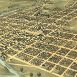
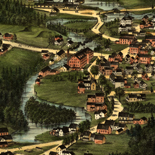
Birds eye view of Ocilla, Georgia 1908.
Perspective map not drawn to scale.
Contributor: Fowler, T. M. Site: American Memory-cultural - Main Catalog Original Format: Map Date: 1908 View catalog record -
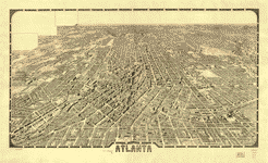
Atlanta.
Perspective map not drawn to scale.
Contributor: Foote and Davies Company (Atlanta, Ga.) Site: American Memory-cultural - Main Catalog Original Format: Map Date: 1919 View catalog record -

Coast of South Carolina from Charleston to Hilton Head.
Scale 1:200,000.
Contributor: United States Coast Survey Site: American Memory-cultural - Main Catalog Original Format: Map Date: 1862 View catalog record -

Camp McDonald; a school of Instruction for the 4th Brigade Georgia Volunteers
Scale 1:2400.
Contributor: McClellan, I. B. Site: American Memory-cultural - Main Catalog Original Format: Map Date: 1917 View catalog record -

[Map of part of Georgia and South Carolina].
Portion of an unidentified printed map showing roads, railroads, towns, and drainage.
Site: American Memory-cultural - Main Catalog Original Format: Map Date: 1865 View catalog record -
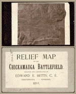
Relief map of the Chickamauga Battlefield /
Photograph of a relief model. Photograph is nearly illegible.
Contributor: Betts, Edward E. Site: American Memory-cultural - Main Catalog Original Format: Map Date: 1893 View catalog record -

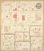
Sanborn Fire Insurance Map from Palmetto, Fulton County, Georgia.
1 Sheet(s). Mar 1900.
Site: American Memory-cultural Original Format: Map Date: 1900-01-01 -

Ft. McAllister.
Scale not given.
Site: American Memory-cultural - Main Catalog Original Format: Map Date: 1864 View catalog record -
Sanborn Fire Insurance Map from Mount Vernon, Montgomery County, Georgia.
1 Sheet(s). Jul 1913.
Site: American Memory-cultural Original Format: Map Date: 1913-01-01 -

Battle-field of Chickamauga. [Sept 18-20, 1863].
Scale ca. 1:84,000.
Contributor: Wells, Jacob Site: American Memory-cultural - Main Catalog Original Format: Map Date: 1887 View catalog record -

Atlanta : from Vincent's subdivision map, published by the City Council /
From Vincent's subdivision map of the city of Atlanta, Dekalb County, state of Georgia. Savannah : Edward A. Vincent, 185-.
Contributor: United States. Army of the Cumberland. Topographical Engineers Office Site: American Memory-cultural - Main Catalog Original Format: Map Date: 1864 View catalog record -
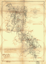
Map showing the operations of the national forces under the command of Maj. Gen. W.T. Sherman during the campaign resulting in the capture of Atlanta, ...
Shows dates and troop positions in northwestern Georgia between Chattanooga and Atlanta.
Contributor: Hergesheimer, E. Site: American Memory-cultural - Main Catalog Original Format: Map Date: 1864 View catalog record -
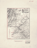
Map of the Atlanta Campaign /
Relief shown by hachures.
Contributor: Western and Atlantic Railroad Company Site: American Memory-cultural - Main Catalog Original Format: Map Date: 1887 View catalog record -

Map by which the Creek Indians gave their statement at Fort Strother on the 22nd Jany, 1816 : [Alabama and Georgia].
Shows Alabama and Georgia from the Tombigbee River in the west to the southern Great Smoky Mountains and the Savannah River in the east and indicating U.S. Army forts in that region.
Site: American Memory-cultural - Main Catalog Original Format: Map Date: 1816 View catalog record -

A new & accurate map of the provinces of North & South Carolina, Georgia &c.
Scale ca. 1:2,900,000.
Contributor: Bowen, Emanuel Site: American Memory-cultural - Main Catalog Original Format: Map Date: 1752 View catalog record -
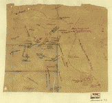
[Union troop positions northwest of Marietta, Georgia, June 10-July 3, 1864].
Relief shown by hachures.
Site: American Memory-cultural - Main Catalog Original Format: Map Date: 1864-07-03 View catalog record -

Sanborn Fire Insurance Map from Palmetto, Fulton County, Georgia.
1 Sheet(s). Mar 1890.
Site: American Memory-cultural Original Format: Map Date: 1890-01-01 -
Georgia, Chickamauga and Chattanooga National Military Park (Chickamauga Battlefield) /
Scale 1:9,600 or 1 in. = 800 ft.
Contributor: Geological Survey (U.S.) Site: American Memory-cultural - Main Catalog Original Format: Map Date: 1975 View catalog record -

Map illustrating the military operations in front of Atlanta, Ga. From the passage of Peach Tree Creek, July 19th 1864, to the commencement of the ...
Scale ca. 1:32,000.
Contributor: United States. Army. Corps of Engineers Site: American Memory-cultural - Main Catalog Original Format: Map Date: 1875 View catalog record -

Sanborn Fire Insurance Map from Moultrie, Colquitt County, Georgia.
12 Sheet(s). Aug 1912.
Site: American Memory-cultural Original Format: Map Date: 1912-01-01
Refine your search
Original Format
- Map
- Web Page [1]
Online Format
Contributor
- Sneden, Robert Knox [30]
- Lindenkohl, A. [15]
- Western And Atlantic Railroad Company [11]
- United States Coast Survey [8]
- United States. Army. Dept. of The Cumberland. Topographical Engineers [8]
- United States. Army of The Cumberland. Topographical Engineers Office [5]
- Geological Survey (U.S.) [5]
- United States. National Park Service [5]
- Poe, O. M. [5]
- Blakeslee, G. H. [4]
-
More Contributors