
![[December 21, 1944], HQ Twelfth Army Group situation map.](https://cybercemetery.unt.edu/archive/oilspill/20121207195940im_/http://www.loc.gov/collections/static/world-war-II-maps-military-situation-maps-from-1944-to-1945/images/ict21200.jpg)

![A correct map of a section of the United States showing the allignment [sic] of the Pittsburgh, Marion, and Chicago Railway between Chewton, Penna. and Marion, Ohio and connections.](https://cybercemetery.unt.edu/archive/oilspill/20121207195940im_/http://www.loc.gov/collections/static/railroad-maps-1828-to-1900/images/rr005350.jpg)
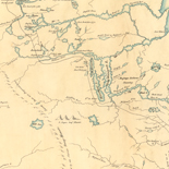
![Carte particulière d'une partie de la Louisianne ou les fleuve et rivierres [i.e. rivières] onts etés relevé a l'estime & les routtes [i.e. routes] par terre relevé & mesurées aux pas, par les Srs. Broutin, de Vergés, ingénieurs & Saucier dessinateur](https://cybercemetery.unt.edu/archive/oilspill/20121207195940im_/http://www.loc.gov/collections/static/louisiana-european-explorations-and-the-louisiana-purchase/images/ct000681.jpg)
![[Topographical map of part of Washington D.C.].](https://cybercemetery.unt.edu/archive/oilspill/20121207195940im_/http://www.loc.gov/collections/static/civil-war-maps/images/cw0688500.jpg)


![[December 23, 1944], HQ Twelfth Army Group situation map.](https://cybercemetery.unt.edu/archive/oilspill/20121207195940im_/http://www.loc.gov/collections/static/world-war-II-maps-military-situation-maps-from-1944-to-1945/images/ict21202.jpg)
Results
-

A Map of Ticonderoga with the old and new lines and batteries,
Scale ca. 1:2,300.
Site: American Memory-cultural - Main Catalog Original Format: Map Date: 1777 View catalog record -

Plan of the position which the army under Lt. Genl. Burgoyne took at Saratoga, on the 10th of September 1777, and in which it remained ...
Scale ca. 1:108,000.
Site: American Memory-cultural - Main Catalog Original Format: Map Date: 1777 View catalog record -

Campaigns of the American Civil War--atlas /
Title from cover.
Contributor: Fiebeger, G. J. Site: American Memory-cultural - Main Catalog Original Format: Map Date: 1914 View catalog record -

New Haven Harbor
[Scale 1:30,000].
Contributor: United States Coast Survey Site: American Memory-cultural - Main Catalog Original Format: Map View catalog record -

Plan of the siege of St. Sebastian in the year 1813.
Relief shown by hachures.
Site: American Memory-cultural - Main Catalog Original Format: Map Date: 1813 View catalog record -

Map illustrating the operations of the U.S. forces against Vicksburg /
Relief shown by hachures.
Contributor: United States Coast Survey Site: American Memory-cultural - Main Catalog Original Format: Map Date: 1863 View catalog record -

A survey of Frog's Neck and the rout[e] of the British Army to the 24th of October 1776, under the command of His Excellency the ...
Scale 1:24,000; 2,000 ft. to 1 in.
Contributor: Blaskowitz, Charles Site: American Memory-cultural - Main Catalog Original Format: Map Date: 1776 View catalog record -

Topographical sketch of the country adjacent to the turnpike between Nolensville and Chapel Hill, Tenn. /
Relief shown by hachures.
Contributor: Weyss, J. E. Site: American Memory-cultural - Main Catalog Original Format: Map Date: 1863 View catalog record -

Campagne en Virginie du Major Général M'is de LaFayette : ou se trouvent les camps et marches, ainsy que ceux du Lieutenant Général Lord Cornwallis ...
Covers central Virginia from Orange County in the north to Isle of Wight County in the south, and west to Cumberland County.
Contributor: Capitaine du Chesnoy, Michel Site: American Memory-cultural - Main Catalog Original Format: Map Date: 1781 View catalog record -

Map of Virginia : showing the distribution of its slave population from the census of 1860 /
"Sold for the benefit of the sick and wounded of the U.S. Army."
Contributor: Graham, H. S. Site: American Memory-cultural - Main Catalog Original Format: Map Date: 1861 View catalog record -

Camp McDonald; a school of Instruction for the 4th Brigade Georgia Volunteers
Scale 1:2400.
Contributor: McClellan, I. B. Site: American Memory-cultural - Main Catalog Original Format: Map Date: 1917 View catalog record -

Map showing the locations of the battlefields of Fredericksburg, Hamilton's Crossing, Chancellorsville, Salem Church, Wilderness, [and] Spotsylvania, and also showing the boundaries of the battlefield ...
Scale ca. 1:90,000.
Contributor: Kishpaugh, Robert A. Site: American Memory-cultural - Main Catalog Original Format: Map Date: 1906 View catalog record -

Charleston Harbor and its approaches showing the positions of the Rebel batteries.
[Scale 1:30,000].
Contributor: United States Coast Survey Site: American Memory-cultural - Main Catalog Original Format: Map Date: 1863 View catalog record -

Route from Manassas to Centreville, August 28th to 31st.
Legend at the bottom of the map gives the marking for the route of the headquarters train of General Heintzelman under whom Sneden served.
Contributor: Sneden, Robert Knox Site: American Memory-cultural Original Format: Map Date: 1861 -

Military map of the vicinity of Frankfort, Kentucky /
Shows streets, rivers and creeks, locations of the arsenal and "U.S. Hd. Qrs.," and recommended defensive positions.
Contributor: Brooks, J. H. Site: American Memory-cultural - Main Catalog Original Format: Map Date: 1863 View catalog record -

[Map of Drewry's Bluff, Chesterfield Co., Va.]
"Chief Engineer's Office, D.N.V., Maj. Gen. Jeremy Francis Gilmer, Chief Engineer."--printed on map.
Site: American Memory-cultural Original Format: Map Date: 1864 -

Birds eye view of Louisiana, Mississippi, Alabama and part of Florida
Scale not given.
Contributor: Bachmann, John Site: American Memory-cultural - Main Catalog Original Format: Map Date: 1861 View catalog record -

British camp at Trudruffrin from the 18th. to the 21st. of September 1777, with the attack made by Major General Grey against the rebels near ...
Scale ca. 1:31,680.
Site: American Memory-cultural - Main Catalog Original Format: Map Date: 1778 View catalog record -

Plan of the battle of Chantilly, Virginia. Fought Septr. 1st 1862, 5 to 10 PM.
Color coding indicates the location of Union and Confederate forces.
Contributor: Sneden, Robert Knox Site: American Memory-cultural Original Format: Map Date: 1862 -

Map of a part of eastern North Carolina from a map in progress /
"Maj. Gen. J.F. Gilmer, Chief Engineer"--map.
Site: American Memory-cultural Original Format: Map Date: 1864
Refine your search
Original Format
- Map
Online Format
Contributor
- Sneden, Robert Knox [277]
- United States Coast Survey [33]
- United States. Army. Corps of Engineers [29]
- Hotchkiss, Jedediah [22]
- Michler, N. [20]
- United States. Central Intelligence Agency [20]
- Weyss, J. E. [14]
- Abbot, Henry L. [13]
- Western And Atlantic Railroad Company [12]
- Blakeslee, G. H. [11]
-
More Contributors